Surveying vessel for underwater topographic surveying and mapping

An underwater terrain, surveying vessel technology, applied in surveying devices, surveying and navigation, special purpose vessels, etc., can solve problems such as underwater terrain with difficult obstacles, and no early warning of reefs.

Active Publication Date: 2020-10-23
安徽二水测绘院有限公司
View PDF10 Cites 10 Cited by
  • Summary
  • Abstract
  • Description
  • Claims
  • Application Information

AI Technical Summary

Problems solved by technology

[0005] The purpose of the present invention is to provide a surveying ship for underwater terrain surveying, to solve the technical problems in the prior art that it is impossible to give early warning to hidden reefs and it is difficult to measure the underwater terrain of obstacles

Method used


Image

  • Surveying vessel for underwater topographic surveying and mapping
  • Surveying vessel for underwater topographic surveying and mapping
  • Surveying vessel for underwater topographic surveying and mapping

Examples


Embodiment Construction

[0033] The following will be combined with Figure 1 to Figure 7 The present invention is described in detail, and the technical solutions in the embodiments of the present invention are clearly and completely described. Apparently, the described embodiments are only some of the embodiments of the present invention, not all of them. Based on the embodiments of the present invention, all other embodiments obtained by persons of ordinary skill in the art without making creative efforts belong to the protection scope of the present invention.

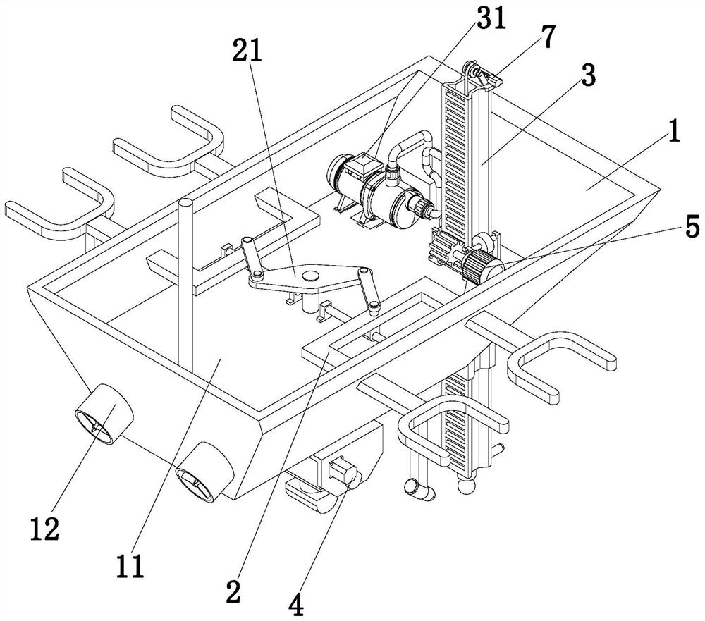
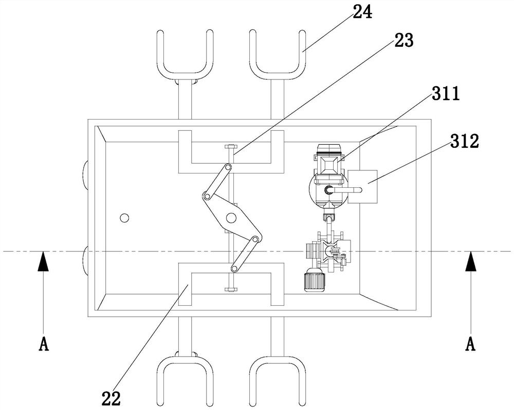
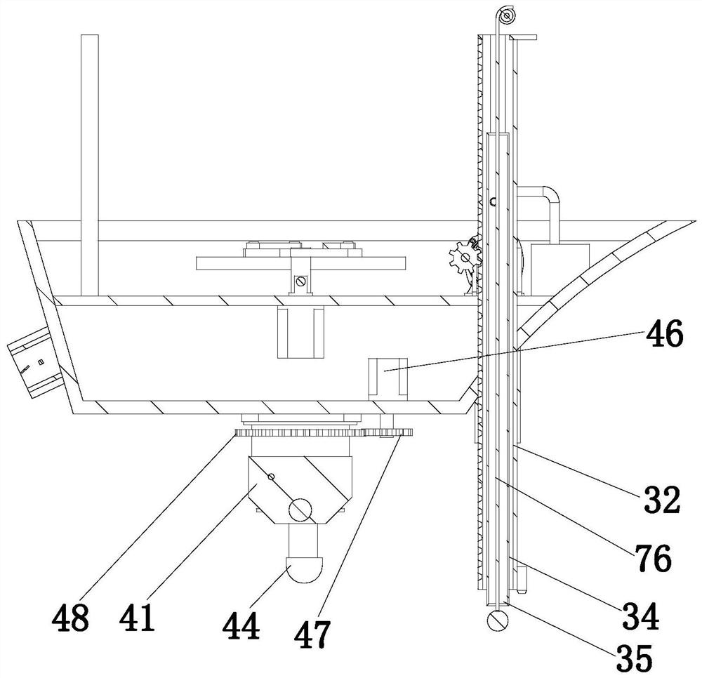
[0034] The present invention provides a kind of surveying ship for underwater terrain surveying and mapping here by improving, as Figure 1-Figure 7 As shown, it includes a survey hull 1, an anti-overturn mechanism 2, a water quality and depth detection mechanism 3, and an underwater terrain boundary detection mechanism 4;

[0035] The survey hull 1 is provided with a ship plate 11, the anti-overturn mechanism 2 is arranged on the top of ...


PUM


Abstract

The invention belongs to the technical field of engineering surveying and mapping auxiliary devices, and relates to a surveying ship for underwater topographic surveying and mapping. The surveying vessel comprises a surveying ship body, an anti-tipping mechanism, a water quality and water depth detection mechanism and an underwater topography boundary detection mechanism. A ship plate is arrangedon the surveying ship body; the water quality and water depth detection mechanism comprises a sealing assembly, a water sample collection assembly, a lifting square pipe and a lifting assembly, a sampling pipe is arranged in the lifting square pipe, and a sealing sliding sleeve is arranged at the bottom of the survey ship body; and the underwater topography boundary detection mechanism comprises an angle adjusting assembly, a mounting frame, a swing plate, a topography boundary detection sensor and a rotating cylinder. In the invention, an angle position of the topography boundary detection sensor can be further changed under the action of the underwater topography boundary detection mechanism; and a underwater depth is detected under the action of the water quality and water depth detection mechanism, water samples at different depths can be collected, and a situation that the ship body safety of the surveying ship body is affected due to the fact that the surveying ship body collideswith a submerged reef can be avoided.

Description

technical field [0001] The invention relates to the technical field of engineering surveying and mapping auxiliary devices, in particular to a surveying ship used for underwater terrain surveying and mapping. Background technique [0002] In the prior art, aerial photography is basically used for land surface topography measurement, and aerial photography cannot be used for underwater topography measurement. Usually, the underwater measurement methods are different according to different water areas. , In rivers and lakes with a small area of ​​calm water flow, the topographic map can be measured by using theodolite, electromagnetic wave rangefinder, ruler, etc. For rivers with fast-flowing water, other special methods are needed for measurement. Due to the size and draft of the ship, it is difficult for the ship to measure certain waters (such as shallow water near the coast, reef areas, etc.), which requires an unmanned survey ship to reduce the scale necessary for ship su...

Claims


Application Information

Patent Timeline
Patent Type & Authority Applications(China)
IPC IPC(8): B63B35/00B63B43/02B63B43/18G01C13/00
CPCB63B35/00B63B43/02B63B43/18G01C13/00
Inventor 韩丙红
Owner 安徽二水测绘院有限公司
Why Eureka
Try Eureka