Coal mine resource mining area geological disaster monitoring and early warning management system based on big data

A technology of geological disasters and big data, applied in the field of geological disaster monitoring and early warning management system in coal mine resource mining areas, can solve the problems of normal life impact, comprehensive analysis of geological disaster risk assessment coefficient, low monitoring level, etc., so as to reduce the occurrence rate of geological disasters , the effect of ensuring the safety of life and property and reducing economic losses

Inactive Publication Date: 2020-10-23
詹晨
View PDF0 Cites 3 Cited by
  • Summary
  • Abstract
  • Description
  • Claims
  • Application Information

AI Technical Summary

Problems solved by technology

However, the current coal mining in my country has caused a series of geological disasters in mining areas, which have seriously affected people's normal life and even endangered people's lives and property.
[0003] The current geological disaster monitoring technology mainly judges geological subsidence based on the degree of surface cracking observed by the naked eye. It cannot accurately monitor geological disasters in all areas of coal mine resource development, and cannot monitor the soil softness at a certain distance from the ground in each sub-region, and the monitoring level is low. , the accuracy is not high, and at the same time, people cannot monitor the groundwater level drop and the movement of the earth's crust with the naked eye, and cannot comprehensively analyze the geological disaster risk assessment coefficients of each sub-region based on the monitoring data, and cannot judge whether they are in danger or not based on the geological disaster risk assessment coefficients. area, and then avoid the economic loss caused by geological disasters in dangerous latent areas. In order to solve the above problems, the present invention designs a monitoring and early warning management system for geological disasters in coal mining resource mining areas based on big data.

Method used


Image

  • Coal mine resource mining area geological disaster monitoring and early warning management system based on big data

Examples


Embodiment Construction

[0029] The technical solutions in the embodiments of the present invention will be clearly and completely described below with reference to the accompanying drawings in the embodiments of the present invention. Obviously, the described embodiments are only a part of the embodiments of the present invention, but not all of the embodiments. Based on the embodiments of the present invention, all other embodiments obtained by those of ordinary skill in the art without creative efforts shall fall within the protection scope of the present invention.

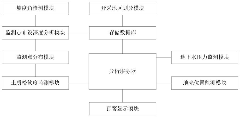
[0030] see figure 1 As shown, a geological disaster monitoring and early warning management system based on big data in coal mining resource mining areas, including mining area division module, slope angle detection module, monitoring point layout depth analysis module, monitoring point layout module, soil softness monitoring module, groundwater Pressure monitoring module, crustal position monitoring module, early warning display modu...


PUM


Abstract

The invention discloses a coal mine resource mining area geological disaster monitoring and early warning management system based on big data. The system comprises a mining area division module, a slope angle detection module, a monitoring point arrangement depth analysis module, a monitoring point distribution module, a soil texture softness monitoring module, an underground water pressure monitoring module, a crustal position monitoring module, an early warning display module, an analysis server and a storage database. According to the invention, the mining area division module, the monitoring point arrangement depth analysis module and the monitoring point distribution module are used for dividing a coal mine resource mining area, distributing monitoring points in the plurality of divided sub-regions, thus analyzing the geological disaster risk assessment coefficient comprehensively by monitoring the soil softness, the underground water level descending height and the earth crust deviation distance, obtaining the dangerous latent sub-regions through comparison, performing prevention and treatment through early warning display, reducing the geological disaster occurrence rate ofa coal mine resource mining region, and ensuring the life and property safety of people.

Description

technical field [0001] The invention relates to the technical field of geological disaster monitoring, and relates to a monitoring and early warning management system for geological disasters in coal mine resource mining areas based on big data. Background technique [0002] As a major energy country in the world, my country has carried out large-scale coal mining activities for a long time, and its mining of a large number of coal resources has contributed to my country's economic construction. However, the current coal mining in my country has caused a series of geological disasters in mining areas, which have seriously affected people's normal life, and even endangered people's life and property safety. [0003] The current geological disaster monitoring technology mainly judges geological subsidence based on the degree of surface cracking observed with the naked eye. It is impossible to accurately monitor the geological disasters in all areas of coal mine resource develo...

Claims


Application Information

Patent Timeline
Patent Type & Authority Applications(China)
IPC IPC(8): G06Q50/02G06Q10/06G01D21/02
CPCG01D21/02G06Q10/0635G06Q50/02
Inventor 詹晨许强
Owner 詹晨
Why Eureka
Try Eureka