Three-dimensional background map rapid filling method based on OpenGL

A filling method and map technology, applied in the field of radar background map drawing, can solve the problem of map cross-pole and other problems, and achieve the effect of improving accuracy, improving interaction efficiency, and reducing the amount of calculation.

Pending Publication Date: 2020-10-23
中国船舶集团有限公司第七二四研究所
View PDF5 Cites 1 Cited by
  • Summary
  • Abstract
  • Description
  • Claims
  • Application Information

AI Technical Summary

Problems solved by technology

The invention uses a three-dimensional background map to avoid the distortion caused by the map projection method, and at the same time solves the problem of the map crossing poles

Method used


Image

  • Three-dimensional background map rapid filling method based on OpenGL
  • Three-dimensional background map rapid filling method based on OpenGL

Examples


Embodiment Construction

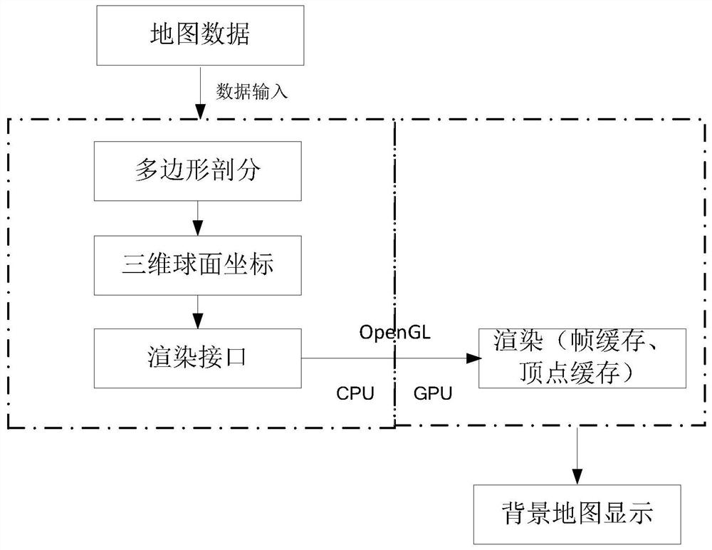
[0015] The method for quickly filling a three-dimensional background map based on OpenGL provided by the present invention has the following specific implementation steps:

[0016] 1. According to the original latitude and longitude coordinates of the map data, a closed map boundary area is formed, such as national boundaries, provincial boundaries, lakes, and oceans.

[0017] 2. Detect the enclosed area without complex polygons with holes inside. There should be no voids in the enclosed area, and no intersection except for adjacent sides.

[0018] 3. Use the split algorithm for the enclosed area to form several minimum graphics units, such as triangles, quadrilaterals or other graphics units supported by OpenGL.

[0019] 4. Record the coordinate information, longitude and latitude of each smallest graphic unit.

[0020] 5. Convert the plane coordinate information (longtitude, latitude) of the smallest graphic unit into spherical coordinates (x, y, z) in the three-dimensional Cartesian...


PUM


Abstract

The invention relates to the field of radar background map drawing, in particular to a method capable of displaying longitude and latitude coordinate data in real time in a three-dimensional background map form through an OpenGL graphics library, and the method can be used as a background map for radar situation display. A closed area is formed by adopting a longitude and latitude direct projection mode for geographic coordinate information, and the closed area is segmented into minimum graphic units (triangles and quadrangles) supported by OpenGL by adopting a segmentation filling algorithm.And the method further includes converting the coordinate information of the minimum graphic unit into a spherical position coordinate, and filling the minimum graphic unit in the three-dimensional model by using OpenGL. Vertex cache, a model view matrix and a projection matrix are adopted, and frequent data interaction between a CPU and a GPU is reduced. Through matrix inverse transformation, transformation from screen coordinates to world coordinates is realized, and a real-time roaming scaling function is realized.

Description

Technical field [0001] The invention relates to the field of radar background map drawing, and is a method for real-time display of longitude and latitude coordinate data in the form of a three-dimensional background map through an OpenGL graphics library, and can be used as a background map for radar situation display. Background technique [0002] The superimposed display of radar echo video, secondary target and electronic chart can accurately provide the position relationship between ships, static targets and dynamic targets within the power range, and provide commanders with a clear display of the battlefield situation, which is helpful for rapid And accurate decision-making and command. However, professional electronic charts have many elements, including various electronic channels, berths, anchorages, and other deep water areas, and the background colors are different. These areas are directly superimposed on the radar echo video, and sometimes the echo cannot be clearly ...

Claims


Application Information

Patent Timeline
Patent Type & Authority Applications(China)
IPC IPC(8): G06T17/10G06T7/11G06T15/00
CPCG06T17/10G06T15/005G06T7/11G06T2207/10012
Inventor 耿开元陈婧林悦王善民
Owner 中国船舶集团有限公司第七二四研究所
Why Eureka
Try Eureka