Grassland rodent damage monitoring method based on low-altitude remote sensing

A low-altitude remote sensing and rodent-infestation technology, applied in instruments, character and pattern recognition, scene recognition, etc., can solve problems such as loss of grassland resources, aggravation of grassland degradation and desertification, and inability to know the accuracy, achieving low cost and convenient operation. , the effect of high efficiency

Pending Publication Date: 2020-11-03
SICHUAN NORMAL UNIVERSITY
View PDF1 Cites 12 Cited by
  • Summary
  • Abstract
  • Description
  • Claims
  • Application Information

AI Technical Summary

Problems solved by technology

Since the 1990s, my country's grassland rodents have occurred frequently, which not only caused serious losses to grassland resources, but also exacerbated the degradation and desertification of grasslands. Traditional medium and high-resolution satellite images are difficult to meet the high precision of grassland rodent monitoring. Requirements, with the rapid development of low-altitude remote sensing technology, a new direction has appeared in the research of rodent monitoring. With the wide application of drones in the industry, remote sensing technology is developing at an unprecedented speed to ultra-high Due to the high resolution of satellite images, it is difficult to accurately obtain information on rodent damage on the ground. UAV images have sub-meter spatial resolution, and the sensor can be changed according to research needs, and the flight height can be adjusted to obtain centimeter-level resolution. This will greatly affect the expression of ground rodent damage information on the image, making the rodent damage information have more abundant features
[0003] CN201710636249.5, a UAV pasture management system and method. The invention provides a UAV pa

Method used


Image

  • Grassland rodent damage monitoring method based on low-altitude remote sensing
  • Grassland rodent damage monitoring method based on low-altitude remote sensing
  • Grassland rodent damage monitoring method based on low-altitude remote sensing

Examples


Embodiment Construction

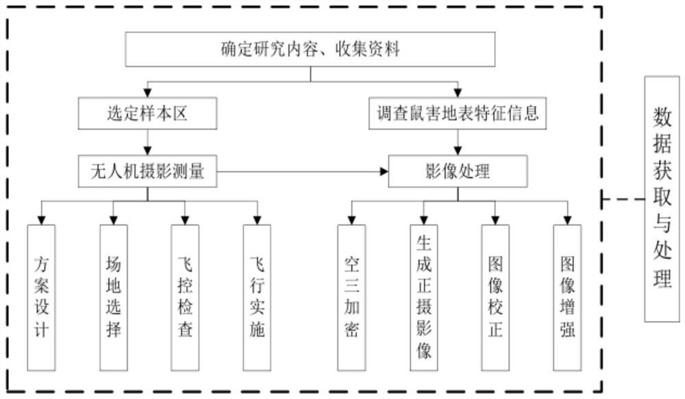
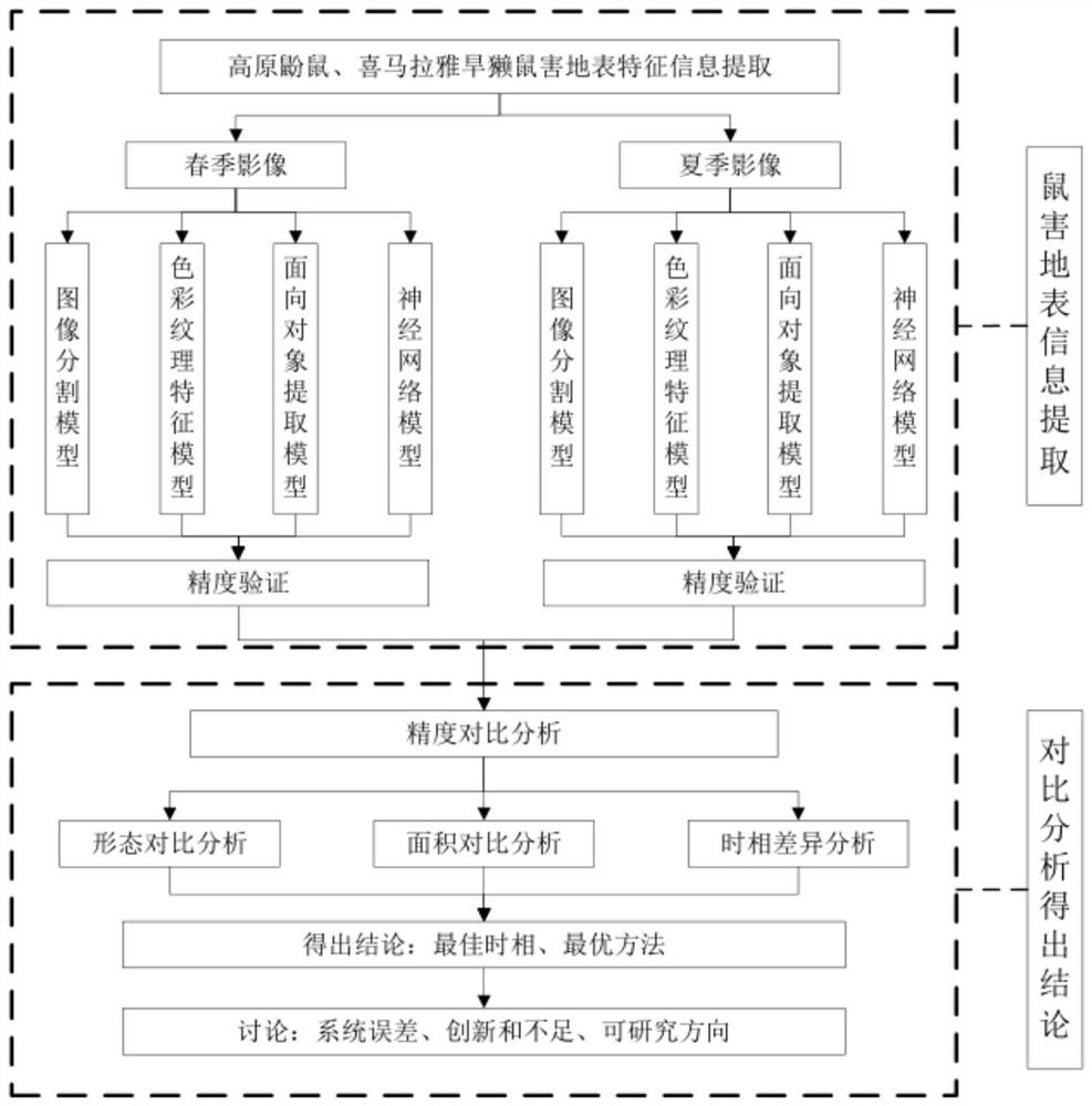
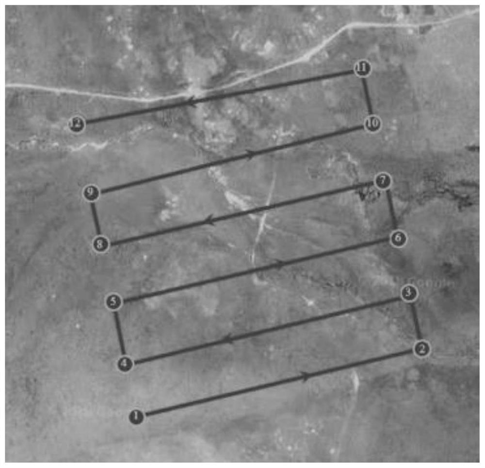
[0046] Below in conjunction with the appendix of the present invention Figure 1-15 , clearly and completely describe the technical solutions in the embodiments of the present invention, obviously, the described embodiments are only some of the embodiments of the present invention, not all of them. Based on the embodiments of the present invention, all other implementations can be obtained by those skilled in the art without making creative efforts.

[0047] In the description of the present invention, it should be understood that the terms "counterclockwise", "clockwise", "longitudinal", "transverse", "upper", "lower", "front", "rear", "left", The orientation or positional relationship indicated by "right", "vertical", "horizontal", "top", "bottom", "inner", "outer", etc. is based on the orientation or positional relationship shown in the drawings, and is only for the purpose of It is convenient to describe the present invention, but does not indicate or imply that the devic...


PUM


Abstract

The invention relates to the field of rat damage image processing, and aims at providing a grassland rat damage monitoring method based on low-altitude remote sensing, and the method comprises the steps: obtaining an aerial photo of an experiment region through an unmanned plane, processing the aerial photo through a Pix4D map platform, and obtaining four low-altitude remote sensing orthoimages; wherein the images comprise a zokor damage area image in spring, a zokor damage area image in summer, a marmot damage area image in spring and a marmot damage area image in summer. On the basis of fully mastering surface features of different rodent damages, surface rodent damage information of four images is extracted one by one by using four methods of gray threshold segmentation, color texture optimization, rule-based object-oriented and BP neural networks, and then the extraction precision is evaluated by using double evaluation standards of spatial precision and quantitative precision so as to obtain the surface rodent damage information of the four images. The method for extracting the rat damage information in the images in different seasons is reasonable in structure, ingenious in design and suitable for popularization.

Description

technical field [0001] The invention relates to the field of obtaining rodent damage information by low-altitude remote sensing, in particular to a grassland rodent damage monitoring method based on low-altitude remote sensing. Background technique [0002] For a long time, due to people's emphasis on grassland utilization and light management, rodent damage has become one of the main factors threatening grassland ecological security, seriously restricting the sustainable development of grassland animal husbandry [4-6]. Since the 1990s, my country's grassland rodents have occurred frequently, which not only caused serious losses to grassland resources, but also exacerbated the degradation and desertification of grasslands. Traditional medium and high-resolution satellite images are difficult to meet the high precision of grassland rodent monitoring. Requirements, with the rapid development of low-altitude remote sensing technology, a new direction has appeared in the research...

Claims


Application Information

Patent Timeline
IPC IPC(8): G06K9/00G06K9/34G06Q50/02
CPCG06Q50/02G06V20/13G06V20/41G06V20/46G06V10/267
Inventor 程武学董光熊瑞东王艺积
Owner SICHUAN NORMAL UNIVERSITY
Why Eureka
Try Eureka