Supercharge Your Innovation With Domain-Expert AI Agents!

Indoor map acquisition method and system based on image recognition

An indoor map and image recognition technology, applied in image analysis, image data processing, character and pattern recognition, etc., can solve the problems of error-prone, large workload, and inability to automatically record the path of the driving trajectory, and achieve a small workload and reliable high sex effect

Pending Publication Date: 2020-11-03
GUANGDONG POWER GRID CO LTD +1
View PDF0 Cites 0 Cited by
  • Summary
  • Abstract
  • Description
  • Claims
  • Application Information

AI Technical Summary

Problems solved by technology

[0002] At present, professional surveying and mapping instruments are generally used for indoor map collection. Since the indoors do not have GPS positioning conditions, it is impossible to automatically record the route through the driving track.
[0003] Therefore, the current indoor map collection is mainly through manual point-by-point and line-by-line surveying and recording, the workload is very heavy and error-prone

Method used


Image

  • Indoor map acquisition method and system based on image recognition

Examples


specific Embodiment

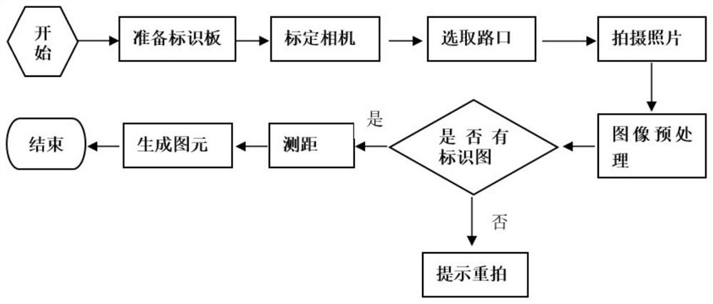
[0048] Firstly, make a specific image mark and calibrate the camera to improve the measurement accuracy. The on-site map collection is completed by two people. A stands at one intersection with a camera, and B stands at the next intersection with a sign board. The two intersections are connected (can be Passage), the sign board held by B is vertical to the ground, facing the camera, A takes photos and records the intersection number and orientation, completes the shooting of each intersection in turn, imports the photos into the computer, and the computer automatically recognizes the signs and calculates them according to the image algorithm. The distance between two intersections, based on the azimuth data and distance data, the computer program automatically generates the intersection and road layer data to complete the drawing.

[0049] The method takes on-site pictures by a camera, uses computer programs to automatically identify and calculate, and automatically generates m...


PUM


Abstract

The invention discloses an indoor map acquisition method and system based on image recognition, and the method comprises the following steps: obtaining scene images shot by a camera at different indoor shooting positions for an indoor specific image identifier, and recognizing the target shape of the specific image identifier in the scene images; based on the target shape of the specific image identifier in the scene image, calculating a path distance between corresponding shooting positions or a path distance from the shooting position to the corresponding specific image identifier; and automatically generating all map primitive data in the system by taking the path distance as a unit. Based on the situation that the indoor map precision requirement is not high, intersection path data information can be automatically recorded through the computer image recognition technology, manual point-by-point and line-by-line surveying and mapping and manual drawing editing are not needed, the workload is small, and the reliability is high.

Description

technical field [0001] The invention relates to the technical field of map collection, in particular to an image recognition-based indoor map collection method and system. Background technique [0002] At present, professional surveying and mapping instruments are generally used for indoor map collection. Since the indoors do not have GPS positioning conditions, it is impossible to automatically record the route through the driving track. [0003] Therefore, the current indoor map collection is mainly through manual point-by-point and line-by-point mapping and recording, which is very heavy workload and prone to errors. Contents of the invention [0004] Therefore, an embodiment of the present invention provides an image recognition-based indoor map collection method and system to solve the problems in the prior art. [0005] In order to achieve the above object, embodiments of the present invention provide the following technical solutions: [0006] The invention provid...

Claims


Application Information

Patent Timeline
IPC IPC(8): G06K9/00G06T7/80G01C21/00
CPCG06T7/80G01C21/005G06V20/00G06V20/54
Inventor 刘丽媛罗金满刘飘郭孝基谭雄华姚子汭
Owner GUANGDONG POWER GRID CO LTD
Features
  • R&D
  • Intellectual Property
  • Life Sciences
  • Materials
  • Tech Scout
  • Unparalleled Data Quality
  • Higher Quality Content
  • 60% Fewer Hallucinations
Learn More