Regional mapping-oriented satellite imaging task planning method and system

A mission planning and imaging technology, which is applied in the field of satellite remote sensing, can solve problems such as unsatisfactory optimization of large target areas, and achieve the effect of improving computing speed and computing accuracy

Pending Publication Date: 2020-11-06
WUHAN UNIV
View PDF0 Cites 2 Cited by
  • Summary
  • Abstract
  • Description
  • Claims
  • Application Information

AI Technical Summary

Problems solved by technology

However, this solution algorithm is only suitable when there are fewer satellite imaging strips,

Method used


Image

  • Regional mapping-oriented satellite imaging task planning method and system
  • Regional mapping-oriented satellite imaging task planning method and system
  • Regional mapping-oriented satellite imaging task planning method and system

Examples


Embodiment Construction

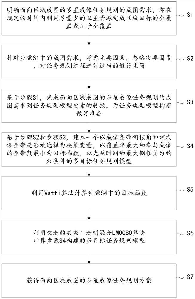
[0064] The technical solution of the present invention will be described in detail below in conjunction with the drawings and embodiments.

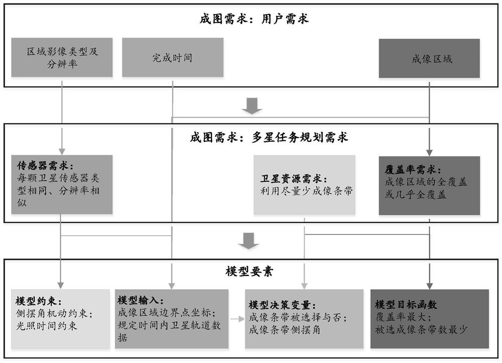
[0065] The present invention is based on the multi-satellite-oriented rapid mapping requirements for large-area targets, considers the main factors, ignores the secondary factors, appropriately simplifies the complex task planning process, and completes the conversion from the core mapping requirements to planning model elements , a multi-satellite imaging task planning model for large area mapping was established, and a multi-satellite imaging task planning method for area mapping was proposed. The present invention is an improvement on the prior art. For the convenience of reference, the embodiment provides a complete process.

[0066] Such as figure 1 As shown, a kind of multi-satellite imaging mission planning method oriented to regional mapping provided by the embodiment includes the following steps:

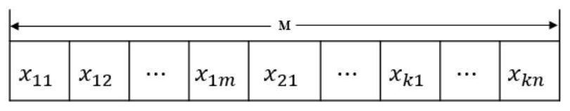
[0067] Step S1, clarify the m...


PUM


Abstract

The invention provides a regional mapping-oriented satellite imaging task planning method and system. The method comprises the following steps: defining a mapping requirement of multi-satellite imaging task planning for regional mapping; performing hypothesis simplification on a task planning process; completing the conversion from the mapping requirements of the multi-satellite imaging task planning for regional mapping to the task planning model elements; the invention is characterized by establishing a multi-target task planning model which takes an imaging strip side swing angle and whether the imaging strip is selected as decision variables, takes maximum coverage rate and minimum number of strips participating in imaging as target functions, and takes illumination time and the maximum side swing angle as constraint conditions; calculating the effective coverage area of an imaging strip in the target function by using a Vatti algorithm; and calculating a multi-target task planningmodel by using an improved real number binary hybrid LMOCSO algorithm to obtain a multi-satellite imaging task planning scheme oriented to region mapping. The technical scheme of the invention can beused for satellite imaging task planning of large target area mapping, such as provincial or national target areas.

Description

technical field [0001] The invention relates to the technical field of satellite remote sensing, in particular to a satellite imaging task planning method and system for area mapping. Background technique [0002] Regional mapping usually refers to the process of generating a regional remote sensing image product through geometric radiation processing and image stitching after using imaging satellites to obtain remote sensing images of the corresponding area. Regional remote sensing image products are widely used in urban planning and construction, land census and monitoring of national conditions, agricultural and forestry changes and monitoring, ecological environment assessment and monitoring, emergency response and rescue, national defense security and many other fields. The basic process of regional mapping includes: 1 imaging mission planning: imaging satellite mission planning to obtain satellite shooting scheme; 2 image acquisition: satellite acquires image data acco...

Claims


Application Information

Patent Timeline
IPC IPC(8): G06F9/48G06N3/12G06Q10/06
CPCG06F9/4843G06N3/126G06Q10/06312
Inventor 陈亚欣沈欣
Owner WUHAN UNIV
Why Eureka
Try Eureka