Longitude and latitude coordinate and image coordinate mapping method

A technology of image coordinates and mapping methods, applied in image enhancement, image analysis, image data processing, etc., can solve problems such as large errors, inability to guarantee a single homography matrix constraint for calibration points, and image coordinates containing errors

Pending Publication Date: 2020-11-10
北京天睿空间科技股份有限公司
View PDF1 Cites 7 Cited by
  • Summary
  • Abstract
  • Description
  • Claims
  • Application Information

AI Technical Summary

Problems solved by technology

Since the coordinate values ​​manually calibrated in practical applications contain errors, and there is no guarantee that the calibration points used to calculate the homography matrix of each local area satisfy the constraints of a single homography matrix at the same time, the obtained image coordinates generally contain errors, and in some cases the errors larger

Method used


Image

  • Longitude and latitude coordinate and image coordinate mapping method
  • Longitude and latitude coordinate and image coordinate mapping method
  • Longitude and latitude coordinate and image coordinate mapping method

Examples


Embodiment Construction

[0049] Below, the present invention will be further described in conjunction with the accompanying drawings.

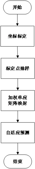
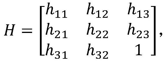
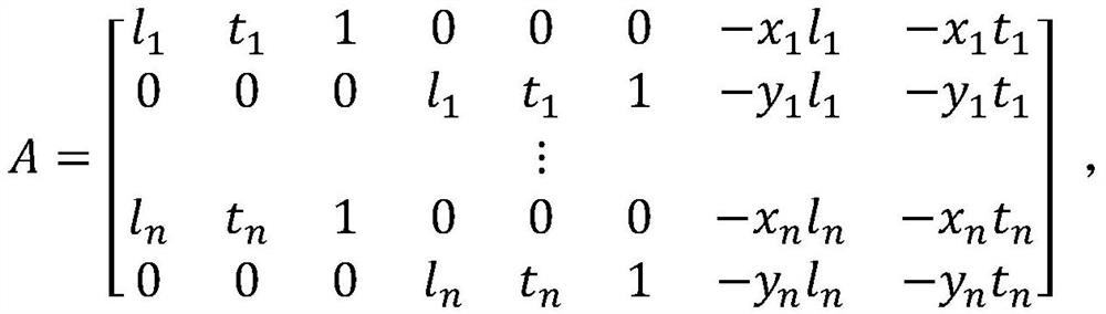
[0050] The overall process of the present invention is as figure 1 shown. First, select a number of points in the scene, use the known measurement data of the scene or tools such as Google Maps to calibrate their longitude and latitude coordinates in the physical space and their pixel coordinates in the image screen, that is, establish the coordinate points in the image (x, y) and the physical world coordinates (l, t), expressed as several quadruples (x, y, l, t). Then, for any point in the given space, a set of mapping points is calculated based on the homography matrix transformation model with different numbers and sampling combinations of adjacent points. Then the outliers with large deviations will be removed to get the final mapping result.

[0051] Specifically, it includes the following main processes:

[0052] 1. Coordinate calibration

[0053] After an ...


PUM


Abstract

The invention relates to a longitude and latitude coordinate and image coordinate mapping method, which comprises the following steps of: selecting a plurality of points in a scene, and calibrating longitude and latitude coordinates of points in a physical space and pixel coordinates of the points in an image picture by using known measurement data of the scene or tools such as a Google map and the like; establishing a corresponding relationship between coordinate points in an image and physical world coordinates, calculating a group of mapping points for any point in a given space on the basis of a homography matrix transformation model by using adjacent points with different numbers and sampling combinations, and deleting outliers with relatively large deviation to obtain a final mappingresult. The mapping method is not only high in precision, but also beneficial to reducing the data processing amount.

Description

technical field [0001] The invention relates to a mapping method between latitude and longitude coordinates and image coordinates. Background technique [0002] In the enhanced display system, it is necessary to enhance and display the relevant information of the object in the scene at the corresponding position on the image; if the object of interest is moving, it is necessary to obtain the spatial position of the object in real time (such as the longitude and latitude from the Beidou system or GPS) coordinate value) and its corresponding image coordinate will be calculated. For example, in airport scene monitoring, in order to let the commander know the flight information of the moving aircraft on the video screen, it is necessary to receive the aircraft's own position information and identity information in real time, and calculate the position of the aircraft on the screen based on the position information. Location, superimposing and displaying information such as iden...

Claims


Application Information

Patent Timeline
Patent Type & Authority Applications(China)
IPC IPC(8): G06F16/29G06T7/70
CPCG06T2207/10016G06T7/70G06F16/29
Inventor 郑文涛林姝含李申达
Owner 北京天睿空间科技股份有限公司
Why Eureka
Try Eureka