Underwater navigation positioning method and system based on SINS/LBL tight integration

A technology of navigation positioning and tight combination, which is applied in the field of underwater navigation and positioning methods and systems based on SINS/LBL tight combination, and can solve the problems of slow convergence speed of positioning errors

Pending Publication Date: 2020-11-24
YUNCHENG UNIVERISTY
View PDF1 Cites 3 Cited by
  • Summary
  • Abstract
  • Description
  • Claims
  • Application Information

AI Technical Summary

Problems solved by technology

[0005] Technical problem: When the submersible enters the working area of ​​the acoustic matrix, in view of the problem of slow convergence of positioning errors in existing navigation technologies, the present invention proposes an unde

Method used


Image

  • Underwater navigation positioning method and system based on SINS/LBL tight integration
  • Underwater navigation positioning method and system based on SINS/LBL tight integration
  • Underwater navigation positioning method and system based on SINS/LBL tight integration

Examples


Embodiment 1

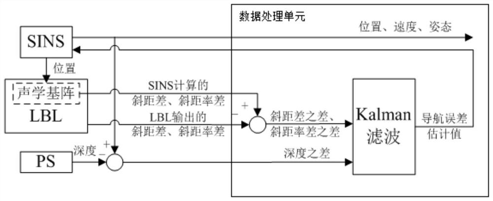
[0092] like figure 1 As shown, an underwater navigation and positioning method based on the tight combination of SINS / LBL, the steps of the method are as follows:

[0093] Step 1, initialize the underwater navigation and positioning system: obtain the initial position parameters of the submersible, obtain the angular velocity and specific force information of the submersible, perform the initial alignment of the strapdown inertial navigation system, and obtain the initial attitude matrix and initial velocity information of the submersible ;

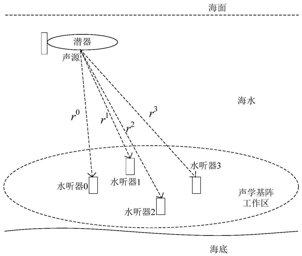
[0094] Step 2, judge the available number of hydrophones in the working area of ​​the acoustic array, when the available number of hydrophones is greater than two, iterate from step 3 to step 5, otherwise stop the iteration and continue to judge the available number of hydrophones The specific judgment method is as follows: Obtain the slant distance of the submersible relative to each hydrophone in the acoustic matrix through the sound s...


PUM


Abstract

The invention discloses an underwater navigation positioning method and system based on SINS/LBL tight integration. The problem that in the prior art, the underwater navigation positioning error convergence speed is low is solved. The invention provides the underwater navigation positioning method based on SINS/LBL tight integration. The system based on the method comprises a strapdown inertial navigation system, a long-baseline underwater acoustic positioning system, a pressure sensor and a data processing unit. Slope distance difference, slope distance rate difference and depth value outputby the strapdown inertial navigation system are subtracted from slope distance difference and slope distance rate difference output by the long-baseline underwater acoustic positioning system and submersible vehicle depth measured by the pressure sensor respectively and then are subjected to Kalman filtering, and navigation error estimation values output by filtering are fed back to correct the strapdown inertial navigation system. According to the method disclosed by the invention, the strapdown inertial navigation system and the long-baseline underwater acoustic positioning system are tightly combined by utilizing the difference of the slant range difference and the difference of the slant range rate difference, so that the navigation positioning precision of an underwater vehicle is effectively improved.

Description

technical field [0001] The invention belongs to the field of navigation and positioning of underwater submersibles, and in particular relates to an underwater navigation and positioning method and system based on a tight combination of SINS / LBL. Background technique [0002] With the development of marine resources and the utilization of marine energy, modern marine high-tech has become a research hotspot in the field of new technologies. Underwater submersibles are the main carrier for underwater exploration and detection. Underwater navigation and positioning are the prerequisites for the normal operation of submersibles. Long endurance and high precision are important indicators for submersible navigation. [0003] Affected by complex underwater environmental factors, long-endurance precise navigation has always been one of the difficulties faced by submersibles. At present, in terms of underwater navigation and positioning technology, submersibles are mainly assisted by ...

Claims


Application Information

Patent Timeline
IPC IPC(8): G01C21/16G01S5/24G01L19/00
CPCG01C21/165G01S5/24G01L19/00
Inventor 周玲孙慧霞窦永梅胡杰朱倚娴
Owner YUNCHENG UNIVERISTY
Why Eureka
Try Eureka