Recursive and refined ground position method and storage medium for optical remote sensing satellite big data

A technology for optical remote sensing and satellite data, applied in the field of remote sensing image processing, can solve problems such as being unsuitable for real-time measurement, unsuitable for large-scale engineering applications, and increasing computational complexity, achieving convenient real-time calculation, simple calculation, and saving computing resources. Effect

Active Publication Date: 2022-02-22
AEROSPACE INFORMATION RES INST CAS
View PDF8 Cites 0 Cited by
  • Summary
  • Abstract
  • Description
  • Claims
  • Application Information

AI Technical Summary

Problems solved by technology

With the continuous increase of optical satellite remote sensing big data, the complexity of calculation is also increasing rapidly. This overall adjustment method is not suitable for real-time calculations, nor is it suitable for large-scale engineering applications.

Method used


Image

  • Recursive and refined ground position method and storage medium for optical remote sensing satellite big data
  • Recursive and refined ground position method and storage medium for optical remote sensing satellite big data
  • Recursive and refined ground position method and storage medium for optical remote sensing satellite big data

Examples


Embodiment Construction

[0074] In order to make the purpose, technical solutions and advantages of the present disclosure clearer, the present disclosure will be further described in detail below in conjunction with specific embodiments and with reference to the accompanying drawings.

[0075] It should be understood, however, that these descriptions are exemplary only, and are not intended to limit the scope of the present disclosure. In the following detailed description, for purposes of explanation, numerous specific details are set forth in order to provide a thorough understanding of the embodiments of the present disclosure. It may be evident, however, that one or more embodiments may be practiced without these specific details. Also, in the following description, descriptions of well-known technologies are omitted in order to avoid unnecessarily obscuring the concept of the present disclosure.

[0076] The terminology used herein is for the purpose of describing particular embodiments only, a...


PUM


Abstract

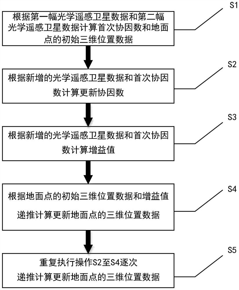
The present disclosure provides a method for recursively refining the ground position of big data from optical remote sensing satellites and a storage medium, including the step of calculating the first cofactor and the ground point based on the first piece of optical remote sensing satellite data and the second piece of optical remote sensing satellite data Initial 3D position data; calculate update cofactor based on newly added optical remote sensing satellite data and first cofactor; calculate gain value based on newly added optical remote sensing satellite data and cofactor; recursively based on initial 3D position data and gain value of ground points Calculate and update the three-dimensional position data of the ground point; repeat the execution of the new optical remote sensing satellite and recursively calculate and update the three-dimensional position data of the ground point; the first optical remote sensing satellite data, the second optical remote sensing satellite data and the newly added optical remote sensing satellite The data includes rotation matrix data; it can be calculated in real time, which improves the calculation efficiency, saves calculation resources, cancels the initial approximation and iteration in traditional calculation, and the update result is accurate and reliable.

Description

technical field [0001] The present disclosure relates to the technical field of remote sensing image processing, and in particular to a recursively refined ground position method and a storage medium for optical remote sensing satellite big data. Background technique [0002] With the development of remote sensing technology, the number of optical remote sensing satellites in orbit has also increased significantly, and satellite remote sensing has the characteristics of big data. Therefore, the amount of optical remote sensing data acquired is increasing, and the types of data are more abundant. The ground position refinement processing of satellite remote sensing big data is the core and key to improve the application of remote sensing big data. According to the refinement process, the accuracy of ground position can be improved. And precision mining is still obviously insufficient. [0003] The accuracy of ground position calculation using optical remote sensing satellit...

Claims


Application Information

Patent Timeline
Patent Type & Authority Patents(China)
IPC IPC(8): G01B11/00
CPCG01B11/00
Inventor 尤红建
Owner AEROSPACE INFORMATION RES INST CAS
Why Eureka
Try Eureka