Real-time monitoring video and three-dimensional scene fusion method based on three-dimensional GIS

A three-dimensional scene, real-time monitoring technology, applied in the field of three-dimensional GIS, to achieve the effect of improving the degree of fluency

Pending Publication Date: 2020-12-08
NANJING GUOTU INFORMATION IND
View PDF0 Cites 16 Cited by
  • Summary
  • Abstract
  • Description
  • Claims
  • Application Information

AI Technical Summary

Problems solved by technology

[0004] In order to solve the problem of fusion display of real-time monitoring video and 3D model data, the present invention provides a method for merging real-time monitoring video and 3D scene based on 3D GIS, using a service-oriented configuration method for front-end loading of scenes and video streams, To meet the needs of smooth browsing of 3D scenes and low-latency transmission of real-time video streams

Method used


Image

  • Real-time monitoring video and three-dimensional scene fusion method based on three-dimensional GIS
  • Real-time monitoring video and three-dimensional scene fusion method based on three-dimensional GIS
  • Real-time monitoring video and three-dimensional scene fusion method based on three-dimensional GIS

Examples


Embodiment Construction

[0044] In order to make the implementation objectives, technical solutions and advantages of the present invention clearer, the technical solutions in the embodiments of the present invention will be clearly and completely described below in conjunction with the accompanying drawings in the embodiments of the present invention. Obviously, the described embodiments are Some embodiments of the present invention are not all embodiments. Based on the implementation manners in the present invention, all other embodiments obtained by persons of ordinary skill in the art without making creative efforts belong to the protection scope of the present invention.

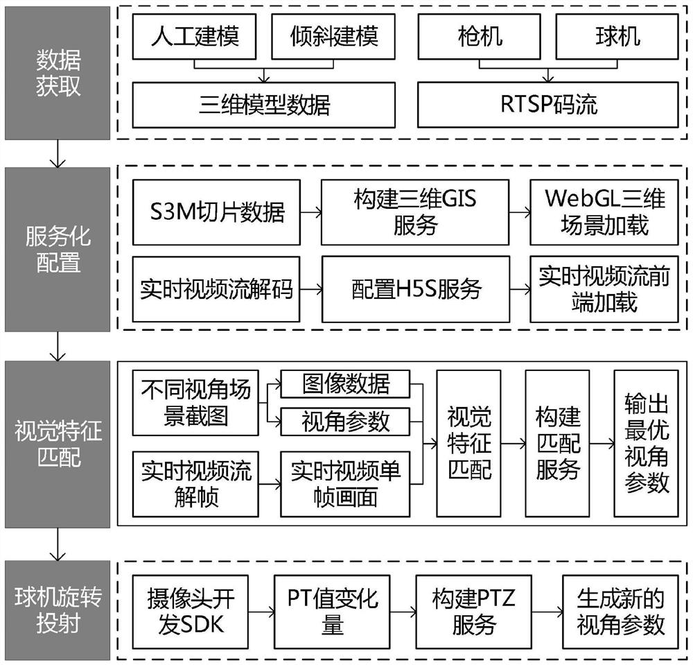
[0045] refer to Figure 1-8 , a kind of real-time surveillance video and three-dimensional scene fusion method based on three-dimensional GIS, comprises the following steps:

[0046] S1 Input the model data, check the texture and the number of triangles of the artificial modeling model using HyperMap iDesktop software, and rem...


PUM


Abstract

The invention discloses a real-time monitoring video and three-dimensional scene fusion method based on a three-dimensional GIS (Geographic Information System), which belongs to the technical field ofthree-dimensional GIS, and comprises the following steps: S1, inputting model data, checking texture and triangular patch number of an artificial modeling model by using hypergraph iDesktop software,removing repeated points, converting a format to generate a model data set, and storing the model data set in a database; performing root node combination and texture compression on the original OSGBformat data by the inclination model; and S2, converting the model data set and the inclined OSGB slice into a three-dimensional slice cache in an S3M format. The live-action fusion method disclosedby the invention is oriented to the fields of public security and smart cities, avoids the application limitation of the traditional two-dimensional map and monitoring video, solves the disadvantage that the monitoring video picture is split, enhances the spatial perception of video monitoring, improves the display performance of multi-path real-time video integration in a three-dimensional sceneto a certain extent, and improves the real-time performance of the three-dimensional scene. The method can be widely applied to the fields of public security and smart cities with strong videos and strong GIS services.

Description

technical field [0001] The invention relates to the technical field of three-dimensional GIS, in particular to a method for fusing real-time monitoring video and three-dimensional scenes based on three-dimensional GIS. Background technique [0002] With the wide application of surveillance video and the vigorous development of GIS technology, video-based GIS technology has been born. The fusion of surveillance video and geospatial data in different scenarios is a research hotspot in video GIS. Existing research results can be roughly divided into two categories according to different association methods: ① time association mode, which is characterized by taking the timestamp as the benchmark, and realizes the synchronous association between video data and GPS positioning information through time index; ② location association mode, which The feature is to perform video association based on camera positioning information. Judging from the current project applications, the fus...

Claims


Application Information

Patent Timeline
Patent Type & Authority Applications(China)
IPC IPC(8): G06T19/00G06T17/05G06T7/33G06T7/73H04L12/24H04L29/06H04N5/232H04N13/246H04N13/279H04N13/296
CPCG06T19/006G06T17/05G06T7/33G06T7/73H04L41/0823H04N13/246H04N13/279H04N13/296H04L65/75H04N23/67H04N23/695
Inventor 沈健韦曼琼徐頔飞殷海军
Owner NANJING GUOTU INFORMATION IND
Why Eureka
Try Eureka