Earth and rockfill dam deformation earthquake damage quantitative evaluation method based on DEM digital terrain analysis

A digital terrain and quantitative evaluation technology, applied in geometric CAD, special data processing applications, design optimization/simulation, etc., can solve the failure of deformation monitoring benchmark failure, the difficulty of analyzing and evaluating the overall deformation of the dam body, and affecting the absolute deformation of the earth-rock dam body Quantity acquisition and other issues

Active Publication Date: 2020-12-11
HUANENG LANCANG RIVER HYDROPOWER +3
View PDF4 Cites 4 Cited by
  • Summary
  • Abstract
  • Description
  • Claims
  • Application Information

AI Technical Summary

Problems solved by technology

[0005] Purpose of the invention: In view of the destruction and failure of the original deformation monitoring benchmark in the hydropower project hub area after the strong earthquake, which affects the acquisition of the absolute deformation value of the earth-rock dam body, and the overall deformation of the dam body is difficult to analyze due to large surface deformation caused by landslides and subsidence Evaluation and other issues, the purpose of the present invention is to provide a method for quantitative evaluation of earth-rock dam deformation earthquake damage based on DEM digital terrain analysis

Method used


Image

  • Earth and rockfill dam deformation earthquake damage quantitative evaluation method based on DEM digital terrain analysis
  • Earth and rockfill dam deformation earthquake damage quantitative evaluation method based on DEM digital terrain analysis
  • Earth and rockfill dam deformation earthquake damage quantitative evaluation method based on DEM digital terrain analysis

Examples


Embodiment Construction

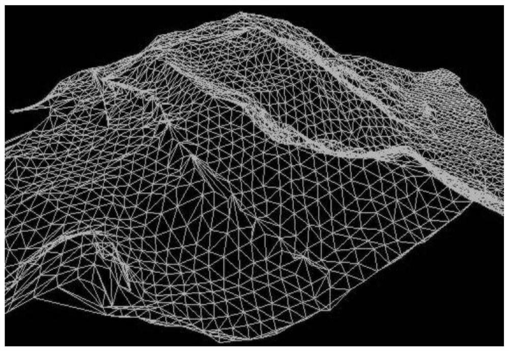
[0030] Digital Elevation Model (DEM), referred to as DEM, is a data set of the plane coordinates of the earth's surface topography and geomorphology grid points and their elevations, or a digital description of the three-dimensional surface shape space feature vectors and their attribute characteristics such as longitude, latitude, and altitude. . Various terrain elements such as slope, aspect, and roughness can be directly or indirectly extracted from DEM.

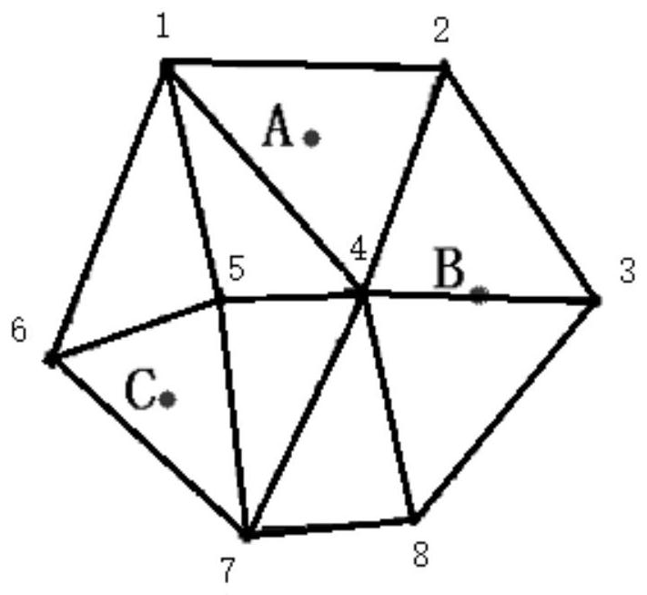
[0031] The construction of DEM mainly adopts regular grid model (Regular Square Grid, RSG) or irregular triangulated network model (Triangulated Irregular Networks, TIN). The data storage method of TIN is more complicated than that of RSG. Its advantage is that it can change the density of sampling points and determine the location of sampling points according to the complexity of terrain fluctuations, and avoid data redundancy in flat terrain. , valley lines, terrain change lines, etc. represent digital elevation featur...


PUM


Abstract

The invention discloses an earth and rockfill dam deformation earthquake damage quantitative evaluation method based on DEM digital terrain analysis. The method comprises the following steps: 1) constructing an earth and rockfill dam DEM model before and after an earthquake; 2) quantitatively analyzing the dam crest and dam slope subsidence or rise; 3) quantitatively analyzing the landslide of thedam body; and 4) quantitatively analyzing the overall displacement and deformation of the dam body. Through statistical analysis of domestic and overseas earth and rockfill dam earthquake damage, main characteristics of earth and rockfill dam deformation earthquake damage are summarized, and on the basis of using a real-time dynamic carrier phase difference measurement technology and meeting rapid and accurate acquisition of earth and rockfill dam deformation earthquake damage monitoring data after an earthquake, an earth and rockfill dam high-precision DEM three-dimensional entity ground model is constructed; through methods of spatial clustering analysis, digital terrain information extraction and the like, DEM three-dimensional dam body models before and after earthquakes of the earthand rockfill dam are compared, and dam body crack space attribute and distribution rule analysis, dam crest and dam slope subsidence or rise overall quantitative analysis, dam body landslide conditionand subsequent influence analysis and dam body overall displacement and deformation quantitative analysis are achieved.

Description

technical field [0001] The invention relates to an evaluation method for earth-rock dam deformation and earthquake damage, in particular to a method for quantitative evaluation of earth-rock dam deformation and earthquake damage based on DEM digital terrain analysis. Background technique [0002] According to the domestic and foreign earth-rock dam earthquake damage survey and statistics, the types of earthquake damage that further focus on the earth-rock dam itself generally include dam body cracks, dam body subsidence, dam body landslide, dam leakage, dam slope uplift or dam toe slope toe displacement, The most common deformation damages are dam cracks, dam subsidence or uplift, and dam landslides. [0003] Earth-rock dams are disaster-bearing bodies in earthquake disasters. On the one hand, the damage of earth-rock dams will cause direct economic losses; Economic losses and casualties. At the same time, after the earthquake, the dams often fail to function as water conse...

Claims


Application Information

Patent Timeline
Patent Type & Authority Applications(China)
IPC IPC(8): G06F30/13G06F30/23
CPCG06F30/13G06F30/23
Inventor 陈豪包腾飞杨明龙赵二峰杨德玮李然陈波曹学兴谭彬钟鸣徐小坤方晗卢俊
Owner HUANENG LANCANG RIVER HYDROPOWER
Why Eureka
Try Eureka