Mobile measurement method fusing SLAM technology in complex environment

A complex environment, mobile measurement technology, used in measurement devices, radio wave measurement systems, navigation through speed/acceleration measurement, etc. The effect of data processing efficiency and precision

Active Publication Date: 2021-01-26
PLA STRATEGIC SUPPORT FORCE INFORMATION ENG UNIV PLA SSF IEU
View PDF6 Cites 14 Cited by
  • Summary
  • Abstract
  • Description
  • Claims
  • Application Information

AI Technical Summary

Problems solved by technology

[0006] The purpose of this application is to provide a mobile measurement method that integrates SLAM technology in a complex environment, to solve the problem of large amount of calculation and the The problem of low precision

Method used


Image

  • Mobile measurement method fusing SLAM technology in complex environment
  • Mobile measurement method fusing SLAM technology in complex environment
  • Mobile measurement method fusing SLAM technology in complex environment

Examples


Embodiment Construction

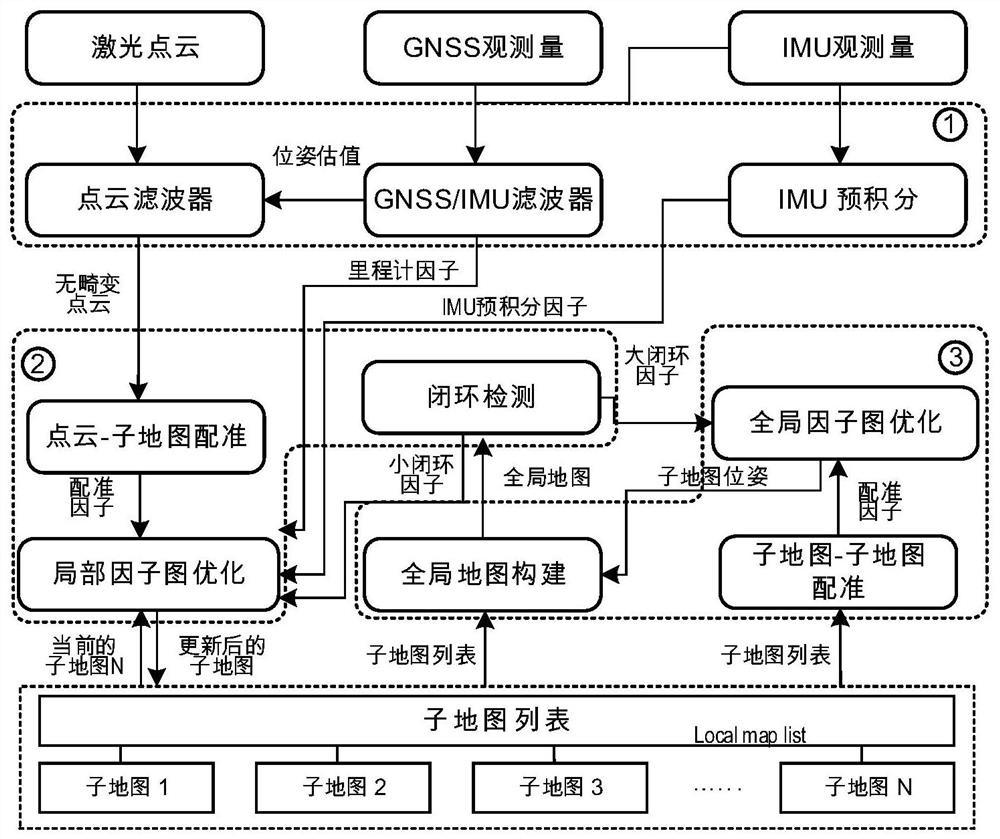
[0027] An embodiment of a mobile measurement method integrating SLAM technology in a complex environment:

[0028] The main idea of ​​the present invention is to obtain the laser point cloud data collected by the laser radar And the GNSS / IMU integrated navigation device outputs the pose of the 6-DOF carrier in an open environment or IMU observations in complex environments (It is also the pose); through the pose transformation of the carrier, the distortion of the laser point cloud data is eliminated, and the SLAM technology is integrated to estimate the complete motion state of the carrier at the sampling time i Among them, θ i is the Lie algebra corresponding to the three-dimensional rotation matrix at the sampling time i; ρ i is the translation vector corresponding to the three-dimensional translation matrix at the sampling time i; v i is the speed of the carrier at the sampling time i; at the same time, it also realizes the overall splicing of laser point cloud dat...


PUM


Abstract

The invention relates to a mobile measurement method fusing an SLAM technology in a complex environment, and belongs to the technical field of point cloud data processing. The measurement method comprises the following steps: acquiring laser point cloud data and the pose of a carrier; eliminating motion distortion of the laser point cloud data by utilizing the pose of the carrier; carrying out theregistration of the sub-maps through the SLAM technology, and constructing a local factor graph, wherein the local factor graph comprises a speedometer factor, an IMU pre-integration factor, a firstregistration factor, a small closed-loop factor and a sub-map; optimizing the local factor graph to obtain a local motion trail of the carrier and an optimized sub-map; constructing a global factor graph by taking the optimized sub-map as an optimization unit, wherein the global factor graph comprises a second registration factor, a continuous registration factor, a large closed-loop factor and aGNSS factor; and optimizing the global factor graph to obtain a global motion trail and a global map of the carrier. According to the method, the SLAM technology and the GNSS/IMU positioning technology are fused, so that the smoothness of the positioning track is effectively improved, and the map construction precision is improved.

Description

technical field [0001] The invention relates to a mobile measurement method integrated with SLAM technology in a complex environment, and belongs to the technical field of point cloud data processing. Background technique [0002] The mobile measurement system (Mobile Mapping System, MMS) usually consists of a vehicle-mounted platform, a positioning module and a laser radar fixed to the vehicle body. The positioning module is a Global Positioning System (Global Navigation Satellite System, GNSS) and an Inertial Navigation System (Inertial Navigation System). , INS) combined positioning and orientation measurement system (Position and Orientation measurement System, POS), that is, the POS positioning module. When the vehicle-mounted platform is moving normally, the high-precision 6DoF pose of the vehicle-mounted platform based on the earth coordinate system is obtained through the POS positioning module. This system has the characteristics of high precision, all-time, and hig...

Claims


Application Information

Patent Timeline
Patent Type & Authority Applications(China)
IPC IPC(8): G01C21/16G01S19/47
CPCG01C21/165G01S19/47
Inventor 李帅鑫李广云王力宗文鹏高扬骏罗豪龙王鹏
Owner PLA STRATEGIC SUPPORT FORCE INFORMATION ENG UNIV PLA SSF IEU
Why Eureka
Try Eureka