Method for realizing sub-meter-level positioning through network-assisted GNSS terminal

A network-assisted, Yami technology, applied in the field of mobile communication and satellite navigation, can solve problems such as application limitations, unrealistic use of non-professional equipment, and inconsistent mobile application scenarios, achieving a low degree of transformation, strong applicability, and user experience. high degree of satisfaction and satisfaction

Active Publication Date: 2021-02-05
BEIHANG UNIV
View PDF4 Cites 3 Cited by
  • Summary
  • Abstract
  • Description
  • Claims
  • Application Information

AI Technical Summary

Problems solved by technology

However, the application of network RTK requires the establishment of large-scale reference stations around the world, which is unrealistic for the use of non-professional equipment; although the post-event PPP accuracy can reach the sub-meter level, it does not match the real-time mobile application scenarios
These factors limit the application of traditional high-precision positioning methods on mobile terminals.

Method used


Image

  • Method for realizing sub-meter-level positioning through network-assisted GNSS terminal
  • Method for realizing sub-meter-level positioning through network-assisted GNSS terminal
  • Method for realizing sub-meter-level positioning through network-assisted GNSS terminal

Examples


Embodiment Construction

[0049] The present invention will be further described below in conjunction with the accompanying drawings and examples. It should be understood that the following examples are intended to facilitate the understanding of the present invention, and have no limiting effect on it.

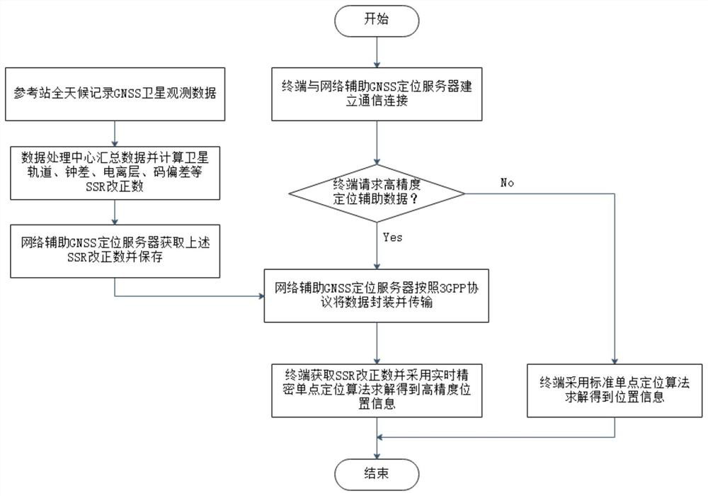
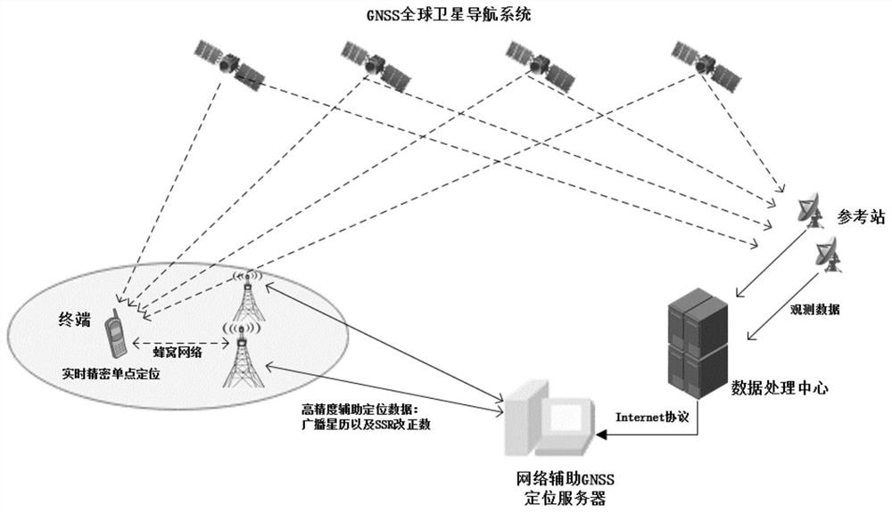
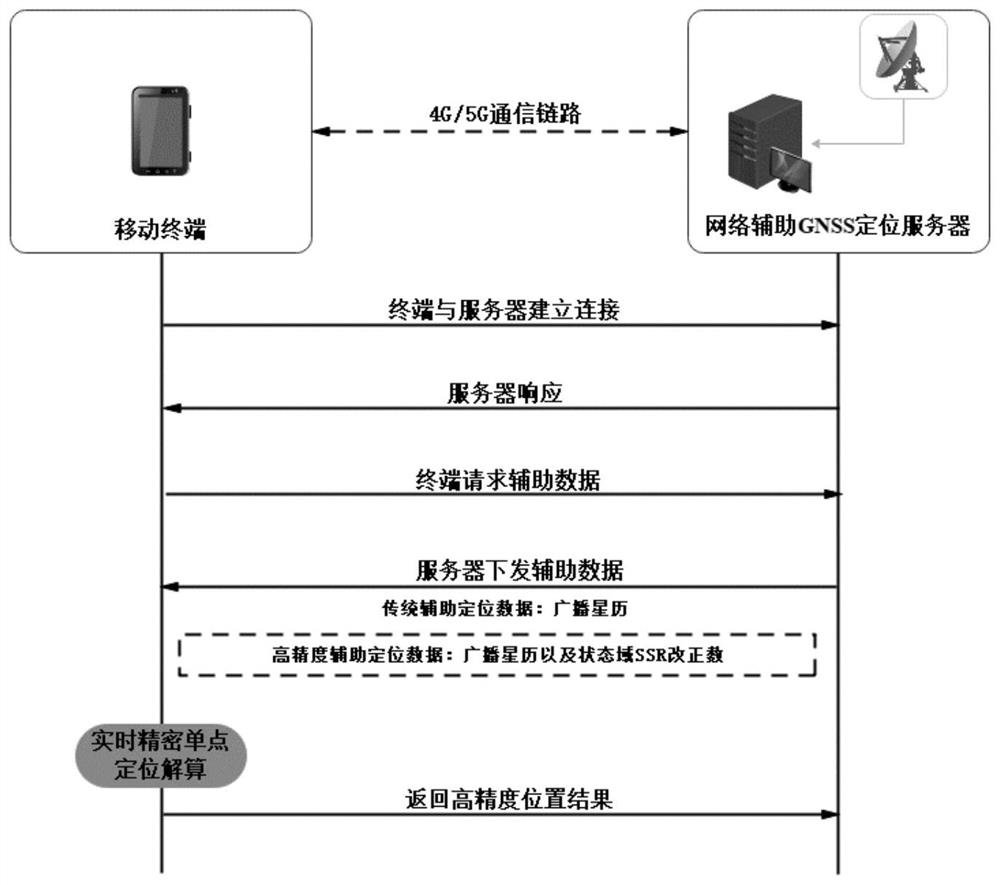
[0050] Combine below Figure 1-3 , to illustrate the sub-meter-level positioning method provided by the network-assisted GNSS positioning server to assist the terminal in this embodiment. The positioning method includes the following steps:

[0051] S1: The ground GNSS reference station monitors the operation status of GNSS satellites around the clock, and records satellite broadcast ephemeris, observation data and other information in real time and summarizes them to the ground data processing center in real time.

[0052] S2: The data processing center calculates the SSR correction number of the four error items of precise satellite orbit, precise clock error, ionospheric delay, and code deviation i...


PUM


Abstract

The invention belongs to the field of mobile communication and satellite navigation, and particularly relates to a method for realizing sub-meter-level positioning through a network-assisted GNSS terminal. On the basis of a traditional positioning mode, state domain SSR correction numbers including satellite orbits, clock differences, ionized layers, code deviations and the like are transmitted tothe terminal, then the mobile terminal obtains high-precision positioning auxiliary data and carries out real-time precision single-point positioning calculation, and wide-area high-precision positioning is achieved. The method can be applied to a smart phone, a tablet personal computer, a measurement type receiver and other devices with a communication function without modifying the hardware structure of the mobile device. Compared with other methods for improving the positioning precision of the terminal, the method provided by the invention has outstanding advantages in the aspects of positioning timeliness, effectiveness, economy and the like, is low in terminal transformation degree, does not need assistance of a reference station, and has relatively great social and economic benefits and the like.

Description

technical field [0001] The invention belongs to the field of mobile communication and satellite navigation, and particularly relates to a method for realizing submeter-level positioning through network-assisted GNSS terminals. Background technique [0002] The global satellite navigation system (GNSS) can provide navigation and positioning services for various users around the world around the clock. The satellite continuously broadcasts navigation messages to ground users, and the terminal receives and decodes the message information to obtain ephemeris data, thereby performing standard single-point positioning. In the scenario where the terminal independently searches for satellites for positioning, the time to first fix TTFF is often long (ranging from tens of seconds to several minutes), which greatly reduces user experience. In order to accelerate the rapid positioning of terminals, mobile devices are basically equipped with network-assisted GNSS assisted positioning f...

Claims


Application Information

Patent Timeline
Patent Type & Authority Applications(China)
IPC IPC(8): G01S19/46
CPCG01S19/46Y02D30/70
Inventor 施闯王家乐郑福
Owner BEIHANG UNIV
Why Eureka
Try Eureka