Soil moisture measurement method and device based on multi-source remote sensing data fusion

A soil moisture and remote sensing data technology, applied in neural learning methods, instruments, biological neural network models, etc., can solve problems such as poor soil moisture measurement results, and achieve the effect of accurate soil moisture measurement results and high spatial and temporal resolution.

Active Publication Date: 2021-03-12
INST OF GEOGRAPHICAL SCI & NATURAL RESOURCE RES CAS
View PDF5 Cites 8 Cited by
  • Summary
  • Abstract
  • Description
  • Claims
  • Application Information

AI Technical Summary

Problems solved by technology

[0008] The purpose of the present invention is to provide a soil moisture measurement method and device based on multi-source remote sensing data fusion, in order to overcome the problem of poor soil moisture measurement results in the above-mentioned prior art

Method used


Image

  • Soil moisture measurement method and device based on multi-source remote sensing data fusion
  • Soil moisture measurement method and device based on multi-source remote sensing data fusion
  • Soil moisture measurement method and device based on multi-source remote sensing data fusion

Examples


Embodiment Construction

[0043] The present invention will be described in detail below with reference to the accompanying drawings and examples. Each example is provided by way of explanation of the invention, not limitation of the invention. In fact, those skilled in the art will recognize that modifications and variations can be made in the present invention without departing from the scope or spirit of the invention. For example, features illustrated or described as part of one embodiment can be used on another embodiment to yield a still further embodiment. Therefore, it is intended that the present invention includes such modifications and variations as come within the scope of the appended claims and their equivalents.

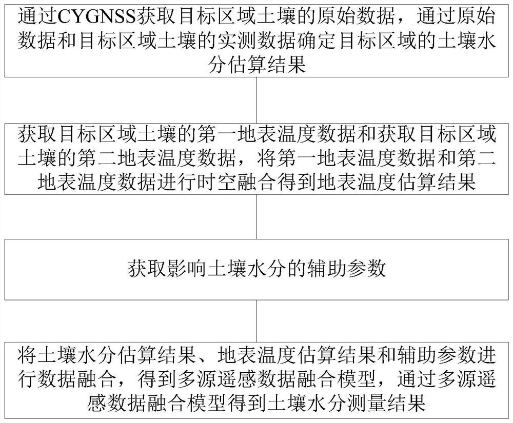
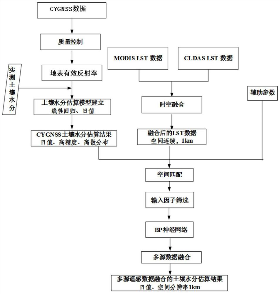
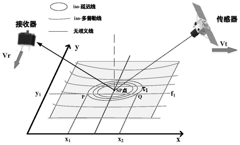
[0044] The soil moisture measurement method based on the fusion of multi-source remote sensing data in the present invention is mainly used to measure the moisture contained in the soil in a certain area. The main technical concept is as follows: figure 1 As shown, the CYGNSS...


PUM


Abstract

The invention provides a soil moisture measurement method and device based on multi-source remote sensing data fusion, which are used for measuring moisture contained in soil in a target area. The method includes: determining a soil moisture estimation result of the target area by acquiring original data of the soil in the target area and measured data of the soil in the target area through a cyclone global navigation satellite system; performing space-time fusion on the obtained first surface temperature data of the target area soil and the obtained second surface temperature data of the target area soil to obtain a surface temperature estimation result; obtaining auxiliary parameters influencing soil moisture, wherein the auxiliary parameters comprise vegetation coverage indexes, the ground elevation, the vegetation coverage, th soil roughness, the ground gradient and the rainfall; and performing data fusion on the soil moisture estimation result, the surface temperature estimation result and the auxiliary parameters to obtain a multi-source remote sensing data fusion model, and obtaining a soil moisture measurement result through the multi-source remote sensing data fusion model. By means of the measuring method, the soil moisture measuring result can be more accurate.

Description

technical field [0001] The invention belongs to the technical field of hydrological remote sensing, and in particular relates to a soil moisture measurement method and device based on fusion of multi-source remote sensing data. Background technique [0002] As a basic parameter in the study of the formation, transformation, and consumption of land surface resources, soil moisture is one of the important parameters of energy and material exchange in the soil-vegetation-atmosphere system, and is also an important determinant of surface energy balance. [0003] Conventional soil moisture surface measurement methods, such as gravimetric measurement and time-domain reflectometry are point-based measurements, which can only represent a small spatial range (0.0025m 2 ), the sampling points are limited and the cost is high. [0004] With the development of remote sensing technology, optical and microwave remote sensing technology has become an important means of estimating soil moi...

Claims


Application Information

Patent Timeline
Patent Type & Authority Applications(China)
IPC IPC(8): G06K9/00G06K9/32G06K9/62G06N3/08
CPCG06N3/084G06V20/188G06V20/13G06V10/25G06F18/25Y02A90/10
Inventor 杨婷孙志刚
Owner INST OF GEOGRAPHICAL SCI & NATURAL RESOURCE RES CAS
Why Eureka
Try Eureka