Method for constructing spatial semantic database based on BIM and GIS data integration

A data integration and database technology, applied in the direction of database models, relational databases, geographic information databases, etc., can solve problems such as geometric and semantic information errors or loss, blurred division relations, and inability to fully integrate BIM and GIS, so as to avoid information missing effect

Pending Publication Date: 2021-03-19
华建数创(上海)科技有限公司
View PDF0 Cites 7 Cited by
  • Summary
  • Abstract
  • Description
  • Claims
  • Application Information

AI Technical Summary

Problems solved by technology

Some mainstream commercial software can also realize the data format conversion between BIM and GIS, but it is limited to the lower level of detail model conversion, the division relationship corresponding to the LOD level is vague, and the degree of coupling with semantic information is not high
IFC and CityGML are common data model standards in the fields of BIM and GIS respectively. The sharing of geometric and semantic information between the two will lay the foundation for the

Method used


Image

  • Method for constructing spatial semantic database based on BIM and GIS data integration
  • Method for constructing spatial semantic database based on BIM and GIS data integration

Examples


Embodiment Construction

[0020] The preferred embodiments of the present invention will be described in detail below in conjunction with the accompanying drawings, and the present invention will be further elaborated.

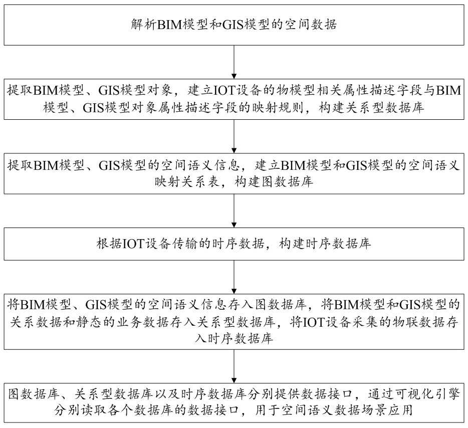
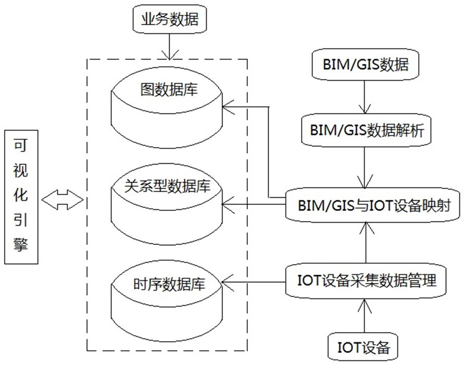
[0021] First, combine the Figure 1~2 A method for constructing a spatial semantic database based on BIM and GIS data integration according to an embodiment of the present invention is described, which is used for data integration of BIM models and GIS models, and has a wide range of application scenarios.

[0022] Such as Figure 1~2 As shown, the method for building a spatial semantic database based on BIM and GIS data integration in the embodiment of the present invention has the following steps:

[0023] In S1, as in Figure 1~2 As shown, the spatial data of the BIM model and the GIS model are parsed.

[0024] In S2, as in Figure 1~2 As shown, according to the parsed spatial data, BIM model and GIS model objects are extracted, and the mapping rules between the object model-rel...


PUM


Abstract

The invention discloses a method for constructing a spatial semantic database based on BIM and GIS data integration. The method comprises the following steps: analyzing spatial data of BIM and GIS models; establishing mapping rules of object model related attribute description fields of IOT equipment and BIM and GIS model object attribute description fields, and constructing a relational database;extracting spatial semantic information, establishing a spatial semantic mapping relation table, and constructing a graph database; constructing a time sequence database according to the time sequence data transmitted by the IOT equipment; storing spatial semantic information in a graph database, storing relational data and static business data in a relational database, storing Internet-of-thingsdata in a time sequence database, and reading data interfaces of all the databases through a visualization engine. According to the method, a data storage standard of a BIM + GIS model is established, and fusion application is realized, so that a digital twin system application mode and a technical framework integrated with key technologies such as ontology, semantic mining, Internet-of-things, big data analysis and the like are constructed.

Description

technical field [0001] The invention relates to the technical field of BIM and GIS data integration, in particular to a method for constructing a spatial semantic database based on BIM and GIS data integration. Background technique [0002] In the context of rapid urbanization, the integration of building information modeling (BIM) and geographic information system (GIS) has been increasingly researched and applied to fields related to architecture and urban management. BIM is the integration of physical and functional information throughout the life cycle of a building, containing rich and detailed structural information. However, BIM often does not include the information of the surrounding environment of the building, and it is difficult to be applied to environmental assessment, resource arrangement and safety analysis. GIS can realize geospatial visualization analysis and decision-making based on the function and physical spatial relationship of the outdoor environment...

Claims


Application Information

Patent Timeline
IPC IPC(8): G06F16/29G06F16/26G06F16/28
CPCG06F16/26G06F16/284G06F16/29
Inventor 董道国方瑾来永政朱洪波韦光辉刘翀位阳
Owner 华建数创(上海)科技有限公司
Why Eureka
Try Eureka