Real-time positioning and mapping method for offshore water area

A real-time positioning, nearshore water technology, applied in image analysis, mapping and navigation, image data processing, etc.

Active Publication Date: 2021-03-26
GUANGDONG UNIV OF TECH
View PDF19 Cites 5 Cited by
  • Summary
  • Abstract
  • Description
  • Claims
  • Application Information

AI Technical Summary

Problems solved by technology

[0003] In view of the above defects, the purpose of the present invention is to propose a real-time positioning and mapping method for near-shore waters, which solves the problem that the existing data collection and processing methods cannot be accurately positioned when applied to near-shore waters

Method used


Image

  • Real-time positioning and mapping method for offshore water area
  • Real-time positioning and mapping method for offshore water area
  • Real-time positioning and mapping method for offshore water area

Examples


Embodiment Construction

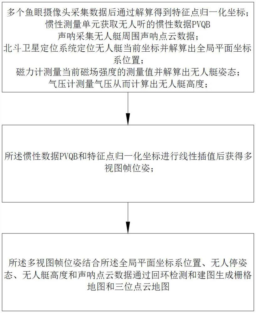
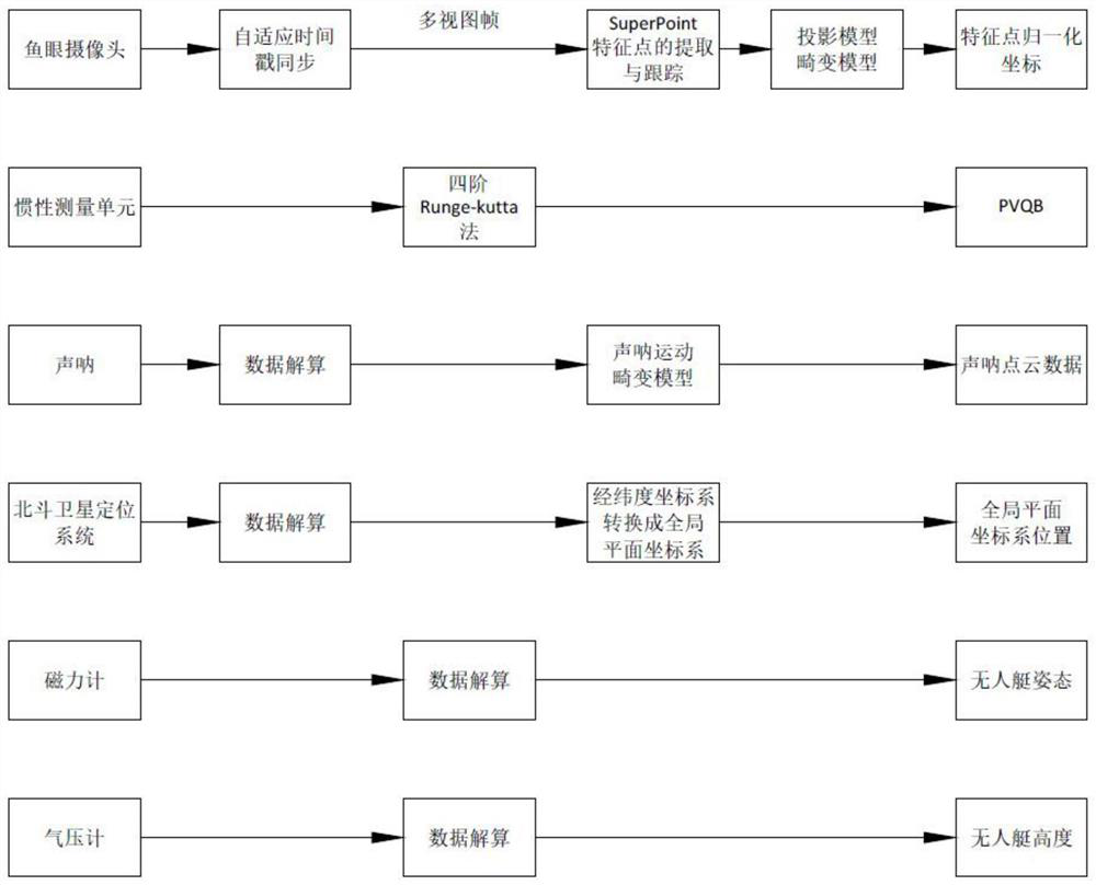
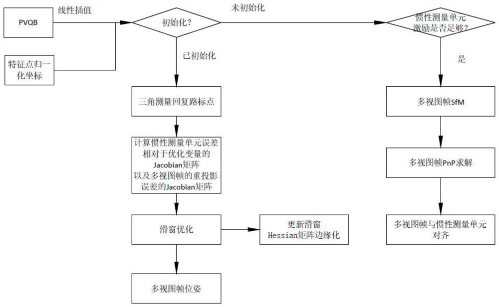
[0024] Embodiments of the present invention are described in detail below, and examples of the embodiments are shown in the drawings, wherein the same or similar reference numerals denote the same or similar elements or elements having the same or similar functions throughout. The embodiments described below by referring to the figures are exemplary only for explaining the present invention and should not be construed as limiting the present invention.

[0025] The following disclosure provides many different embodiments or examples for implementing different structures of embodiments of the present invention. In order to simplify the disclosure of the embodiments of the present invention, components and arrangements of specific examples are described below. Of course, they are only examples and are not intended to limit the invention. Furthermore, embodiments of the present invention may repeat reference numerals and / or reference letters in different instances, such repetiti...


PUM


Abstract

The invention discloses a real-time positioning and mapping method for an offshore water area. The method comprises the following steps: data is obtained by a plurality of fisheye cameras, and thus resolving to obtain normalized coordinates of feature points; the inertia measurement unit acquires inertia data of the unmanned ship; sonar collects sonar point cloud data around the unmanned ship; theBeidou satellite navigation system positions the current coordinates of the unmanned ship and calculates the position of a global plane coordinate system; the magnetometer measures the measured valueof the current magnetic field intensity and calculates the attitude of the unmanned ship; the barometer measures air pressure so as to calculate the height of the unmanned ship; linear interpolationis performed on the inertial data and the normalized coordinates of the feature points to obtain multi-view frame poses; the multi-view frame pose is combined with the global plane coordinate system position, the unmanned ship attitude, the unmanned ship height and the sonar point cloud data to generate a grid map and a three-point cloud map through loopback detection and mapping. The real-time positioning and mapping method for offshore water area solves the problem that an existing data acquisition and processing method is applied to offshore water areas and cannot accurately position the offshore water areas.

Description

technical field [0001] The invention relates to the technical field of data collection and processing of near-shore waters, in particular to a real-time positioning and mapping method for near-shore waters. Background technique [0002] Most of the real-time positioning and mapping systems currently on the market are aimed at land and low-altitude environments where indoor service robots, driverless cars, and drones are located. However, in the near-shore environment on water, since the near-shore environment only has unilateral reference objects, using the existing visual-inertial odometry based on monocular or binocular cameras, the narrow field of view cannot detect enough feature points to achieve accurate Real-time positioning, resulting in inaccurate positioning. In addition, currently used real-time positioning and mapping systems for constructing grid maps and 3D point cloud maps mainly use lidar sensors. As far as we know, the constructed grid map does not provide...

Claims


Application Information

Patent Timeline
Patent Type & Authority Applications(China)
IPC IPC(8): G06T15/00G06N3/04G01C21/16G01D21/02G06Q10/04G06T7/70G08G3/02
CPCG06T15/005G01C21/165G06T7/70G01D21/02G08G3/02G06Q10/047G06N3/045
Inventor 徐雍黄增鸿陈梓杰鲁仁全饶红霞
Owner GUANGDONG UNIV OF TECH
Why Eureka
Try Eureka