A real-time positioning and mapping method for nearshore waters

A technology for real-time positioning and near-shore waters, applied in image analysis, surveying and navigation, image data processing, etc., can solve the problem of inability to accurately locate near-shore waters, and achieve the effect of real-time relocation closed-loop detection

Active Publication Date: 2021-07-27
GUANGDONG UNIV OF TECH
View PDF0 Cites 0 Cited by
  • Summary
  • Abstract
  • Description
  • Claims
  • Application Information

AI Technical Summary

Problems solved by technology

[0003] In view of the above defects, the purpose of the present invention is to propose a real-time positioning and mapping method for near-shore waters, which solves the problem that the existing data collection and processing methods cannot be accurately positioned when applied to near-shore waters

Method used


Image

  • A real-time positioning and mapping method for nearshore waters
  • A real-time positioning and mapping method for nearshore waters
  • A real-time positioning and mapping method for nearshore waters

Examples


Embodiment Construction

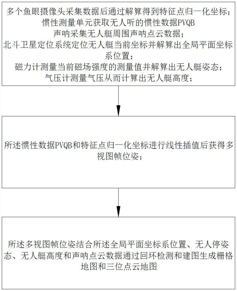
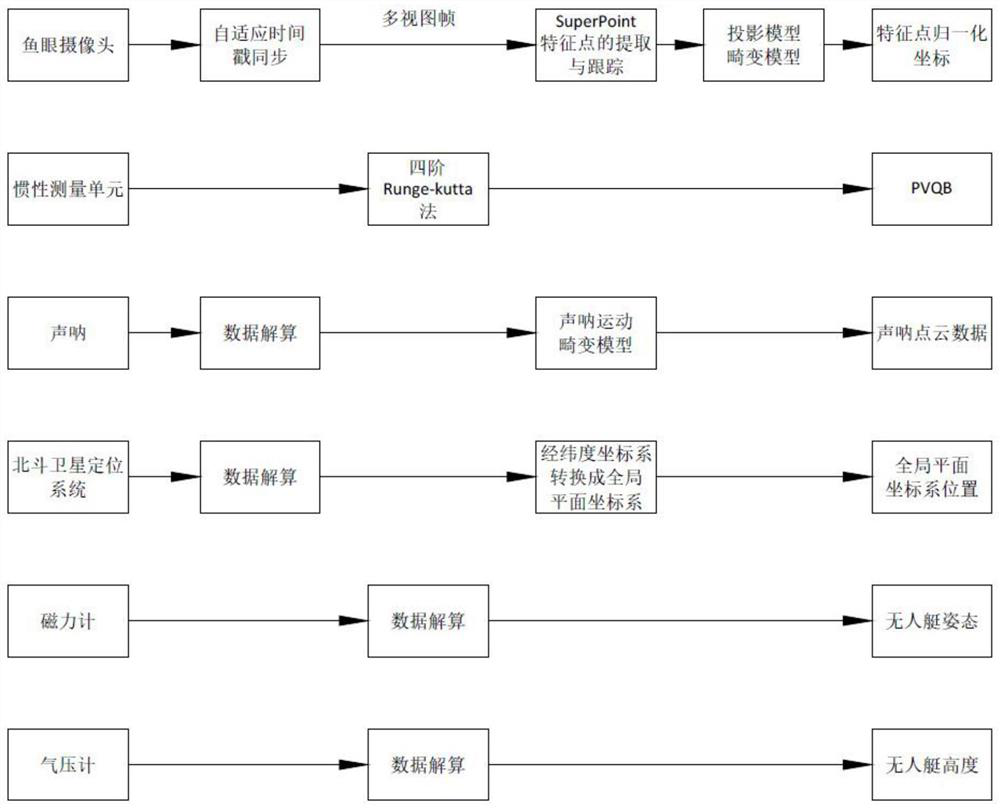
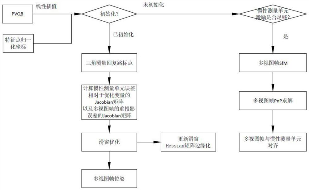
[0024] An example of an embodiment of the present invention will be described in detail below, in which, in the drawings, the same or similar reference numerals are initially referred to as the same or similar elements or elements having the same or similar functions. The embodiments described below are illustrative of the invention, not to be construed as limiting the invention.

[0025] The disclosure of which provides a number of different embodiments or examples of the embodiments of the present invention. To simplify the disclosure of the embodiments of the present invention, the components and settings of a particular example are described below. Of course, they are only examples, and the purpose is not to limit the invention. Further, an embodiment of the present invention can repeat the reference numerals and / or reference letters in different examples. This repetition is to simplify and clear the purpose, which itself does not indicate the relationship between the variou...


PUM


Abstract

The invention discloses a real-time positioning and mapping method for nearshore waters, which comprises a plurality of fish-eye cameras collecting data and obtaining the normalized coordinates of feature points through calculation; an inertial measurement unit acquiring inertial data of an unmanned boat; and a sonar Collect sonar point cloud data around the unmanned boat; the Beidou satellite navigation system locates the current coordinates of the unmanned boat and calculates the position of the global plane coordinate system; the magnetometer measures the measured value of the current magnetic field strength and solves the attitude of the unmanned boat; the barometer measures the air pressure The height of the unmanned boat is thus calculated; the inertial data and the normalized coordinates of the feature points are linearly interpolated to obtain the multi-view frame pose; the multi-view frame pose combines the position of the global plane coordinate system, the attitude of the unmanned boat, the height of the unmanned boat and Sonar point cloud data generates raster maps and three-dimensional point cloud maps through loop closure detection and mapping. The real-time positioning and mapping method for near-shore waters solves the problem that existing data collection and processing methods cannot be accurately positioned when applied to near-shore waters.

Description

Technical field [0001] The present invention relates to the field of data acquisition and processing of near-ceramids, in particular, a real-time positioning and construction method for near-bank waters. Background technique [0002] Most of the real-time positioning and building systems on the current market are for indoor service-like robots, unmanned vehicles and drones in land and low-altitude environments. However, in the near-axis environment, only the unilateral references are only single-sided references, using the visual inertial milemeter based on single or bicker camera, the narrow field of view cannot detect enough feature points to achieve accurate Real-time positioning, thereby appearing in the case where it is not allowed. In addition, the currently used construct grid map and real-time positioning and construction system of the 3D point cloud map, the main use of the sensor is laser radar, but because the effective working environment of the laser radar is on the ...

Claims


Application Information

Patent Timeline
Patent Type & Authority Patents(China)
IPC IPC(8): G06T15/00G06N3/04G01C21/16G01D21/02G06Q10/04G06T7/70G08G3/02
CPCG06T15/005G01C21/165G06T7/70G01D21/02G08G3/02G06Q10/047G06N3/045
Inventor 徐雍黄增鸿陈梓杰鲁仁全饶红霞
Owner GUANGDONG UNIV OF TECH
Why Eureka
Try Eureka