Grid map generation method and system, electronic equipment and storage medium
A raster map and generation system technology, applied in image enhancement, image analysis, image data processing, etc., can solve problems such as high price, large number of points, and long distance, and achieve the effect of reducing the cost of mapping and positioning
- Summary
- Abstract
- Description
- Claims
- Application Information
AI Technical Summary
Problems solved by technology
Method used
Image
Examples
Embodiment 1
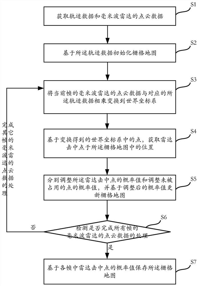
[0064] Such as figure 1 As shown, this embodiment provides a method of generating a raster map, including:
[0065] Step S1: Get the point cloud data of the trajectory data and millimeter waverad;
[0066] Step S2: The grid map is initialized based on the trajectory data;
[0067] Step S3: Multhe to the world coordinate system with the point cloud data of the millimeters of the current frame and the corresponding track data;
[0068] Step S4: Obtain the position in the grid map based on the point in the world coordinate system that is obtained, and obtains the position of the radar in the grid map;
[0069] Step S5: Adjust the probability value of the radar hitting point and the unbeatable point, and update the grid map based on the adjusted probability value;
[0070] Step S6: Detects whether to complete the processing of the point cloud data of all frames, in response to the processing of the point cloud data of all frames of millimeter wave radar, and complete all other frames...
Embodiment 2
[0140] Such as Figure 9 As shown, the present embodiment provides a generating system 100 of a grid map, and the generating system 100 of the grid map includes: data acquisition module 110, initialization module 120, coordinate transformation module 130, hitting point position acquisition module 140, The probability update module 150, the detection module 160 and the map save module 170.
[0141] In this embodiment, the data acquisition module 110 uses point cloud data to acquire trajectory data and millimeters.
[0142]The trajectory data acquired in the data acquisition module 110 is based on, but not limited to, the visual SLAM data, the laser SLAM data, the body data, or millimeters data is generated.
[0143] For example, the trajectory data acquired in the data acquisition module 110 is based on the visual SLAM data generated.
[0144] Among them, the process of generating trajectory data based on visual SLAM data includes:
[0145] 1) When any vehicle is a map construction...
Embodiment 3
[0173] Such as Figure 13 As shown, the present embodiment also provides an electronic device 10, the electronic device 10 including a processor 101, a memory 102. The electronic device 10 is a vehicle terminal, for example, a vehicle, a vehicle box, the electronic device 10 or a mobile terminal in the vehicle, such as a smartphone, PAD, smart glasses, smart bracelet, etc. The method of generating the grid map can be applied to a variety of types of electronic devices 10100. The electronic device 10 can also, for example, include a memory, a memory controller, one or more processing units (CPUs), peripheral interfaces, RF circuits, audio circuitry, speakers, microphones, input / output (I / O) subsystems. , Display, other outputs, or control devices, as well as components such as external ports, including, but not limited to, personal computers such as desktop, laptops, smart TVs. In other embodiments, the electronic device 10 may also be a server, the server can be arranged on on...
PUM
 Abstract
Description
Claims
Application Information
 - R&D
- Intellectual Property
- Life Sciences
- Materials
- Tech Scout
- Unparalleled Data Quality
- Higher Quality Content
- 60% Fewer Hallucinations
Browse by: Latest US Patents, China's latest patents, Technical Efficacy Thesaurus, Application Domain, Technology Topic, Popular Technical Reports.
© 2025 PatSnap. All rights reserved.Legal|Privacy policy|Modern Slavery Act Transparency Statement|Sitemap|About US| Contact US: help@patsnap.com


