Path planning method of grid map

A grid map and path planning technology, which is applied to road network navigators, two-dimensional position/navigation control, navigation calculation tools, etc., can solve the problems of not taking into account the narrow road and low safety, and increase the cost. , the effect of improving the path quality and reducing the search time

Pending Publication Date: 2021-04-20
哈尔滨工业大学芜湖机器人产业技术研究院
View PDF0 Cites 5 Cited by
  • Summary
  • Abstract
  • Description
  • Claims
  • Application Information

AI Technical Summary

Problems solved by technology

[0003] The existing port UAV inspection path planning method based on the improved Astar algorithm establishes a flight site map according to the actual environment of the port, and sets the flight take-off and all mission points; then uses the improved Astar algorithm to plan the path of the starting point and mission points. The method does not take into account the problem of passing through the narrow road. When passing through the narrow road, the path searched by the Astar algorithm is close to the obstacle on one side, and there is a problem of low safety.

Method used


Image

  • Path planning method of grid map
  • Path planning method of grid map
  • Path planning method of grid map

Examples


Embodiment Construction

[0031] The specific implementation of the present invention will be described in further detail below by describing the embodiments with reference to the accompanying drawings, so as to help those skilled in the art have a more complete, accurate and in-depth understanding of the inventive concepts and technical solutions of the present invention.

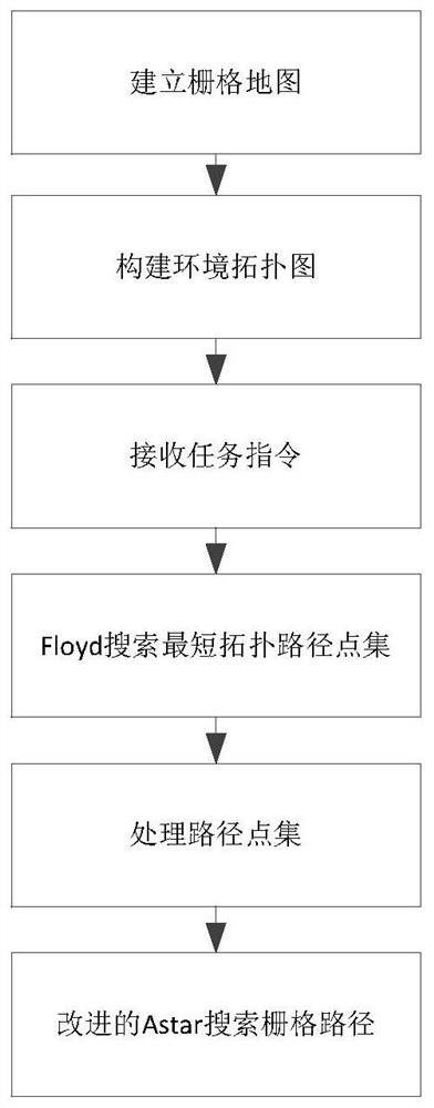
[0032] figure 1 The flow chart of the path planning method for the grid map provided by the embodiment of the present invention, the method specifically includes the following steps:

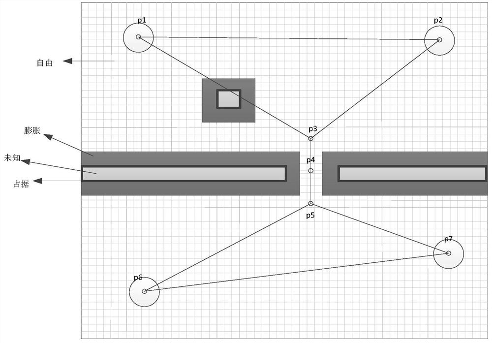
[0033] S1. Construct a grid map based on the operation of the robot, and expand the obstacles in the grid map, such as figure 2 shown;

[0034] The grid map is a grid map of the environment where the robot scans the surrounding environment with the help of two-dimensional lidar. Each grid point has a scanned grid value, and the size occupied by each grid is the grid resolution value. , and record the free area, occupied area and unknown area in th...


PUM


Abstract

The invention discloses a path planning method for a grid map. The method comprises the steps of S1 building a grid map, and carrying out the expansion of an obstacle in the grid map; S2 constructing a topological map, arranging topological points at an outlet and an inlet of a narrow channel, and the two topological points being both located in a safety area of the narrow channel; S3 based on a Floyd algorithm, obtaining a topological path point set from the starting topological point to the ending topological point, deleting the starting topological point and the ending topological point in the topological path point set, and adding the remaining topological points into the path point set; and S4 respectively adding a task starting point and a task ending point at the head and the tail of the path point set, and sequentially planning paths between adjacent path points in the path point set based on an A-stars algorithm to generate a global path point set. The problem that the safety coefficient of trolley walking is not high due to the fact that a trolley walks along a wall during Atar algorithm searching is solved.

Description

technical field [0001] The invention belongs to the technical field of path planning, and more specifically, the invention relates to a path planning method for a grid map. Background technique [0002] As the highest achievement of mechatronics, mobile robots involve various knowledge in the fields of sensor information fusion, system engineering, automatic control technology, etc. To realize the operation of the robot in an unknown environment, it needs to have the ability of real-time and autonomous operation. Path planning is an important link, which directly determines the path of the mobile robot. Path planning refers to how to search for an appropriate moving path from the starting point to the target point for the robot in a static or dynamic, simple or complex operating space, and ensure that the robot can safely and without collision during the movement process. all obstacles. [0003] The existing port UAV inspection path planning method based on the improved As...

Claims


Application Information

Patent Timeline
IPC IPC(8): G01C21/20G01C21/32G01C21/34G05D1/02
Inventor 陈双郑亮孙龙龙陈昕
Owner 哈尔滨工业大学芜湖机器人产业技术研究院
Why Eureka
Try Eureka