Construction engineering cost field surveying and mapping device based on BIM technology

A technology for construction engineering and surveying and mapping devices, which is applied to surveying devices, surveying and mapping and navigation, and surveying instruments, etc., can solve problems such as large errors, time-consuming and labor-intensive, and inaccurate information and data related to building facilities.

Active Publication Date: 2021-04-23
天津市泛亚工程咨询有限公司
View PDF5 Cites 3 Cited by
  • Summary
  • Abstract
  • Description
  • Claims
  • Application Information

AI Technical Summary

Problems solved by technology

[0003] The existing on-site surveying and mapping device for construction project cost based on BIM technology is mainly composed of a tripod and a surveying instrument. Move the tripod once and adjust the adjustment device that comes with the surveying instrument several times until the surveying instrument and the surveying point are centered and in a horizontal state, and then the on-site surveying and mapping can be carried out. However,

Method used


Image

  • Construction engineering cost field surveying and mapping device based on BIM technology
  • Construction engineering cost field surveying and mapping device based on BIM technology
  • Construction engineering cost field surveying and mapping device based on BIM technology

Examples


Embodiment Construction

[0034] The technical solutions in the embodiments of the present invention will be clearly and completely described below in conjunction with the accompanying drawings in the embodiments of the present invention; obviously, the described embodiments are only some embodiments of the present invention; rather than all embodiments. Based on the embodiments of the present invention; all other embodiments obtained by persons of ordinary skill in the art without creative work; all belong to the protection scope of the present invention.

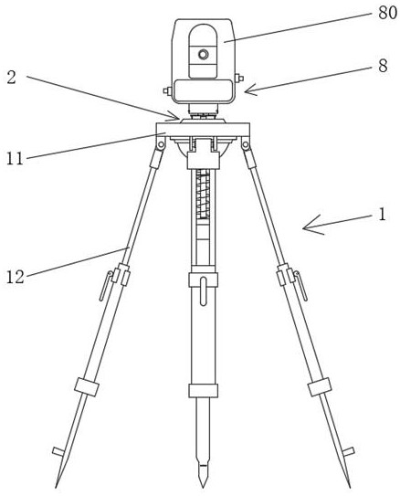
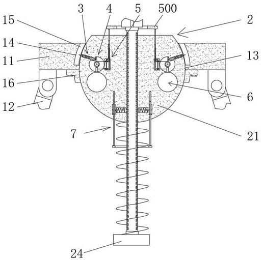
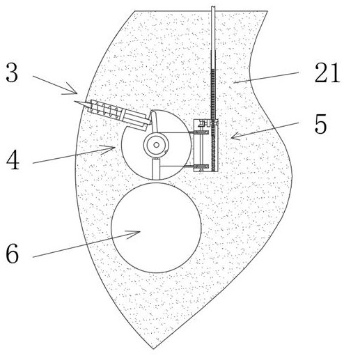
[0035] see Figure 1-11 , a BIM technology-based on-site surveying and mapping device for construction project cost, comprising a tripod 1, and a leveling device 2 is provided on the top of the tripod 1.

[0036] The tripod 1 includes a bearing round platform 11, three supporting legs 12 are movably connected on the bottom surface of the bearing round platform 11, and the three supporting legs 12 are evenly distributed on the bottom surface of the ...


PUM


Abstract

The invention discloses a construction engineering cost field surveying and mapping device based on a BIM technology. The device comprises a tripod, and the top of the tripod is provided with a leveling device; through the cooperation of the tripod, the leveling device, a piercing device, a force application device, a reset device, a monitoring device and a locking device, surveying and mapping personnel can quickly level a clamping device, the leveling speed is high, time and labor are saved, the leveling is not limited by the leveling experience of surveying and mapping personnel, the leveling accuracy is high, through the clamping device, the surveying and mapping personnel can rapidly install a surveying and mapping instrument on the leveling device, the surveying and mapping personnel can rapidly adjust the position height of the clamping device after centering and leveling through a limiting device, then the position height of the clamping device is made to be matched with the height and using habits of the surveying and mapping personnel, and the using comfort is improved; and the practicability of the construction engineering cost field surveying and mapping device based on the BIM technology is improved.

Description

technical field [0001] The invention relates to the field of construction engineering cost on-site surveying and mapping devices, and more specifically, relates to a construction engineering cost on-site surveying and mapping device based on BIM technology. Background technique [0002] BIM technology is a digital tool applied to engineering design, construction, and management. It has the characteristics of visualization, coordination, simulation, optimization, and drawing. Integration of modernization models, sharing and transmission in the whole life cycle of project planning, operation and maintenance, so that engineering and technical personnel can correctly understand and efficiently respond to various building information, and provide design teams and construction and operation units. The construction subjects of all parties provide the basis for collaborative work, and play an important role in improving production efficiency, saving costs and shortening the construc...

Claims


Application Information

Patent Timeline
IPC IPC(8): F16M11/04F16M11/14F16M11/16F16M11/18F16M11/28F16M11/32G01C15/00
Inventor 赵敏
Owner 天津市泛亚工程咨询有限公司
Why Eureka
Try Eureka