Construction method based on rural settlement space form model

A technology of spatial form and construction method, applied in special data processing applications, geometric CAD, design optimization/simulation, etc., can solve problems such as scattered layout, disorderly expansion of urban land, and lack of management and constraints in rural land layout and construction

Pending Publication Date: 2021-04-30
SICHUAN NORMAL UNIVERSITY
View PDF3 Cites 3 Cited by
  • Summary
  • Abstract
  • Description
  • Claims
  • Application Information

AI Technical Summary

Problems solved by technology

However, some experts and scholars believe that in the process of urbanization, there is an "aggressive tendency" in which land expansion is faster than population growth, which restricts the transformation of economic development and urban-rural development, and this large-scale continuous development and construction activities promote the relationship between man and nature. There are irreconcilable contradictions among space, cities and villages, towns, agriculture, and ecology, which leads to a series of problems such as the disorderly expansion of urban land, the "hollowing" of rural areas, and idle homesteads, which are contrary to the concept of intensive use of land resources.
In addition, the layout and construction of rural land use lack effective management and constraints, and the spatial distribution of rural residential areas has been in a state of spontaneous choice by farmers for a long time, resulting in disorderly expansion of rural residential areas. Scattering and other phenomena are very common

Method used


Image

  • Construction method based on rural settlement space form model
  • Construction method based on rural settlement space form model
  • Construction method based on rural settlement space form model

Examples


Embodiment

[0043] D

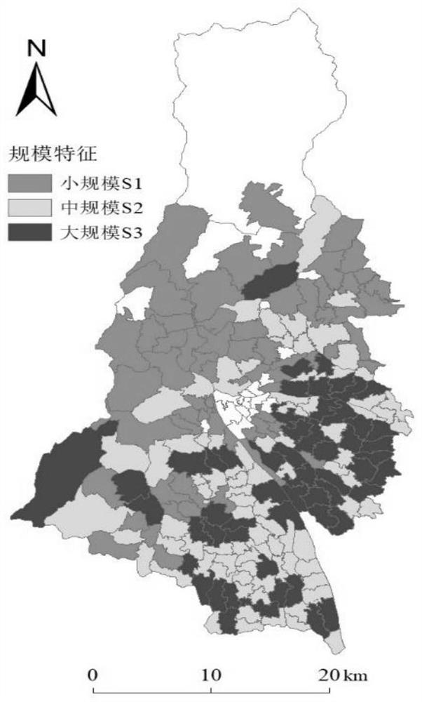
[0044] Dujiangyan City is affiliated to Chengdu City, Sichuan Province. It is located on the northwest edge of the Chengdu Plain, at the mouth of the Minjiang River, between 31°02′09″-31°44′54″ north latitude and 103°25′42″-103°47′ east longitude 0″, it belongs to subtropical monsoon humid climate, with an average annual rainfall of 1243.80mm. It is located across the Longmen Mountain area in western Sichuan and the top of the alluvial fan of the Minjiang River in the Chengdu Plain. It belongs to the eastern edge of the first step of the three stages of China's geomorphological division, that is, from the Qinghai-Tibet Plateau on the first step to the Sichuan on the second step. A typical mountain-plain transition zone in the basin transition.

[0045] The elevation changes drastically from east to west in the territory, and the terrain is distributed in steps from northwest to southeast, followed by high mountains, middle mountains, low mountains, hills and plains...


PUM


Abstract

The invention provides a rural settlement space form model-based construction method. The method comprises the steps of 1, quantitatively recognizing rural settlement scale, density and shape space form characteristics; 2, dividing the scale and the density into three classes by utilizing a natural breakpoint method; 3, dividing the shape features into regular and irregular types; and 4, combining the space form characteristics by using a combination matrix method. The integrated model can effectively identify the space form of rural settlement, can dynamically observe the spatial evolution situation of rural settlement under the support of continuous data, and provides important support for rural land consolidation and rural planning.

Description

technical field [0001] The invention belongs to the technical field of modeling, and in particular relates to a construction method based on a rural settlement spatial form model. Background technique [0002] With the rapid advancement of urbanization and industrialization, historic achievements have been made in social and economic development. The urbanization rate has increased rapidly in a short period of time. According to the latest data, the urbanization rate of the population in 2019 exceeded 60% for the first time, initially completing the transformation from a rural society to an urban society and entering the era of urban society. However, some experts and scholars believe that in the process of urbanization, there is an "aggressive tendency" in which land expansion is faster than population growth, which restricts the transformation of economic development and urban-rural development, and this large-scale continuous development and construction activities promot...

Claims


Application Information

Patent Timeline
Patent Type & Authority Applications(China)
IPC IPC(8): G06F30/13G06F30/20G06F111/08
CPCG06F30/13G06F30/20G06F2111/08
Inventor 任平孙道亮洪步庭张德林
Owner SICHUAN NORMAL UNIVERSITY
Why Eureka
Try Eureka