A Multi-source Positioning Information Fusion Method Applied to Long Endurance UAV Payload

A fusion method and unmanned aerial vehicle technology, applied in satellite radio beacon positioning systems, navigation computing tools, radio wave measurement systems, etc. burden and other issues, to achieve the effect of improving navigation estimation results, enhancing estimation accuracy, and improving work performance

Active Publication Date: 2022-03-15
NAT INNOVATION INST OF DEFENSE TECH PLA ACAD OF MILITARY SCI
View PDF0 Cites 0 Cited by
  • Summary
  • Abstract
  • Description
  • Claims
  • Application Information

AI Technical Summary

Problems solved by technology

But both have certain limitations: for the first method, although the payload is fixedly connected to the UAV, the position information calculated by the integrated navigation system of the UAV can theoretically be equivalent to the position information of the payload, but the second method is The first method does not use the same set of time systems, and there will be deviations; for the second method, due to factors such as size and power consumption, the load generally cannot carry a high-performance positioning system, and the position estimation accuracy is not high
However, the above methods either bring extra consumption and bring a great burden to the UAV, or lack real-time performance and can only rely on post-processing

Method used


Image

  • A Multi-source Positioning Information Fusion Method Applied to Long Endurance UAV Payload
  • A Multi-source Positioning Information Fusion Method Applied to Long Endurance UAV Payload
  • A Multi-source Positioning Information Fusion Method Applied to Long Endurance UAV Payload

Examples


Embodiment Construction

[0046] The specific implementation process of the present invention will be explained and described in detail below in conjunction with the accompanying drawings.

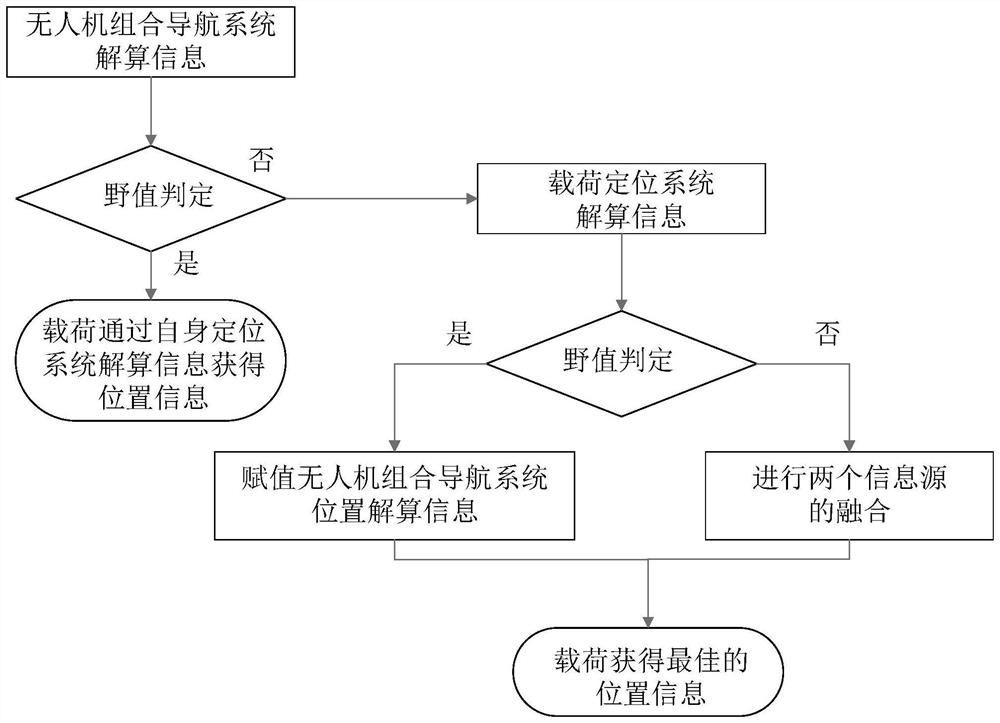
[0047] Usually, in order to complete the corresponding tasks, UAVs will carry different loads, and their position information needs to be calculated in many load work projects. Long-endurance drones generally have their own integrated navigation system. The inertial group will continue to work during the entire flight, and its information is corrected by the onboard navigation satellite positioning equipment, which has high accuracy. In order to realize the self-closed loop, the load often also carries a positioning system, which independently provides position information for the load. The load is fixedly connected to the fuselage, and the information provided by the load positioning system is theoretically the same as that provided by the UAV integrated navigation system. However, because the load positioning sy...


PUM


Abstract

The invention belongs to the technical field of unmanned aerial vehicles and provides a multi-source positioning method for long-endurance unmanned aerial vehicles. First, obtain the initial calculation information of the UAV integrated navigation system and the load system, and judge the outlier value of the UAV integrated navigation system. If the result is an outlier value, the load positioning system uses its own positioning system to calculate the current position information; If it is not an outlier value, then pass the calculation information at the current moment to the positioning system carried by the load; judge the outlier value of the load positioning system, if the obtained calculation information of the load positioning system is an outlier value, only use the UAV The information transmitted by the integrated navigation system is forecasted to obtain the position at the current moment; if neither is an outlier value, the two are fused together, and the position information calculated by the integrated navigation system of the UAV and the position calculated by the load positioning system can be combined. The information is fused to enhance the accuracy of load position estimation, thereby improving the working performance of the load.

Description

technical field [0001] The invention belongs to the technical field of unmanned aerial vehicles, and in particular relates to a multi-source positioning method for long-endurance unmanned aerial vehicles. Background technique [0002] Aeronautical earth observation technology is widely used. With the development of UAVs and various payloads, the use of UAVs to carry payloads for earth observation can achieve higher-precision three-dimensional mapping, wind and wave measurement and other functions. The realization of the above functions needs to solve the position information of the load itself, complete the splicing of the measurement information, and form the measurement results of the target area. There are currently two ways to obtain the location information of the payload. One is to use the integrated navigation system information of the UAV, and the other is to use the information of the payload's own positioning system. But both have certain limitations: For the firs...

Claims


Application Information

Patent Timeline
Patent Type & Authority Patents(China)
IPC IPC(8): G01C21/20G01S19/45G01S19/47
CPCG01C21/20G01S19/45G01S19/47
Inventor 陈磊吕良胡云鹏孟志鹏
Owner NAT INNOVATION INST OF DEFENSE TECH PLA ACAD OF MILITARY SCI
Why Eureka
Try Eureka