Spatial similarity geological disaster prediction method based on feature subset coupling model
What is AI technical title?
AI technical title is built by Patsnap AI team. It summarizes the technical point description of the patent document.
A technology for geological hazards and feature subsets, applied in prediction, character and pattern recognition, instruments, etc., can solve problems such as result interference, improvement of difficult model formulas, and improved robustness and accuracy
Pending Publication Date: 2021-05-18
武汉中地云申科技有限公司
View PDF0 Cites 1 Cited by
Summary
Abstract
Description
Claims
Application Information
AI Technical Summary
This helps you quickly interpret patents by identifying the three key elements:
Problems solved by technology
Method used
Benefits of technology
Problems solved by technology
[0004] Through the above analysis, the problems and defects of the existing technology are: the prediction of the existing geological disaster prediction method is sensitive to environmental changes, and it is difficult to obtain an accurate and stable result
In addition, the existing technology cannot distinguish the factors that contribute to the occurrence of geological disasters, which will cause some interference to the results
[0005] The difficulty in solving the above problems and defects is as follows: the basic prediction method has been deduced for many years, and it is quite mature, so it is difficult to improve the robustness and accuracy from the model formula; at present, the research on the selection of geological disaster hazard factors at home and abroad is comparatively limited. It is difficult to provide sufficient reference, and only rely on limited data to derive appropriate and effective screening schemes
Method used
Image
Click on the blue label to locate the original text in one second.
Reading with bidirectional positioning of images and text.
Examples
Embodiment 1
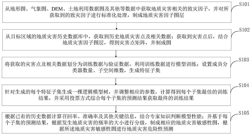
[0120] The prediction of geological hazards based on this model includes the following steps:
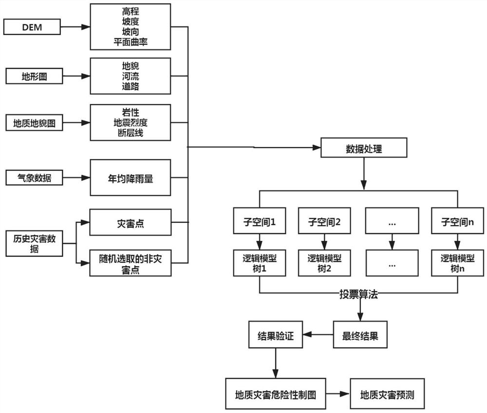
[0121] (1) Extraction of disaster factors, including obtaining disaster-causing factors related to geological hazards from data such as topographic maps, meteorological maps, DEM, and land use data maps, and standardizing the obtained disaster-causing factors to make corresponding layer.
[0122] (2) Acquisition of disaster points. From the historical database of geological disasters in the target area, historical geological disaster points are obtained, including key data such as occurrence time, location, and scope of influence. After obtaining the disaster points, combine the geological disasters in step 1 Factor layer, make a matrix of disaster points, and make a map.
[0123] (3) Make the disaster points obtained in step 2 into training data, set the number of member classifiers and subspace dimensions, and generate feature subsets;
[0124] (4) In each feature subset, genera...
Embodiment 2
[0128] The specific implementation method of the spatial similarity geological hazard prediction based on the feature subset coupling model is as follows:
[0129] (1) Extracting disaster factors. Specifically, Arcgis software can be used to extract key disaster-causing factors, such as slope, aspect, fault, average rainfall, water system, etc., from the topographic map, DEM, weather map, etc. of the target area , after extraction, each factor needs to be normalized. For continuous factors, the following formula can be used for processing:
[0130]
[0131] where μ is the mean of the factor and σ is the standard deviation of the factor. For discrete factors, such as aspect, values can be used instead of categories, such as 1 for true north. After normalization processing, continue to use Arcgis software for mapping to make a hazard map of the target area.
[0132] (2) Obtain the historical disaster data of the target area, select a sufficient number of disaster points t...
PUM
Abstract
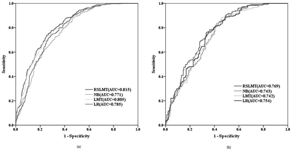
The invention belongs to the technical field of geological disaster prediction, and discloses a spatial similaritygeological disaster prediction method based on a feature subset coupling model, and the method comprises the steps: obtaining disaster-inducing factors related to geological disasters, carrying out the standardizationprocessing of the obtained disaster-inducing factors, and making a geological disaster factor layer; obtaining historical geological disaster points and related data, obtaining a disaster point matrix, and making a map; setting the number of member classifiers and subspace dimensions, and generating a feature subset. A logic model tree is generated for each generated feature subset, corresponding parameters are adjusted, the optimal training result of each subset is obtained through calculation, and model performance is judged; and a corresponding geological disaster sensitivity map is made, and geological disaster risk prediction is performed according to the geological disaster sensitivity map. According to the method, the influence of factors on the prediction result is reduced, and the prediction accuracy is improved.
Description
technical field [0001] The invention belongs to the technical field of geological disaster prediction, and in particular relates to a spatial similarity geological disaster prediction method based on a feature subset coupling model. Background technique [0002] At present, geological disasters are characterized by strong destructive power, strong suddenness, and difficult prevention, which cause a large number of casualties and huge property losses to China every year, so the prediction of geological disasters is imminent. Since the last century, a variety of research methods have been used in the prediction of geological hazards. The most popular is the expert scoring model, which is a qualitative model based on the experience and knowledge of experts to evaluate the contribution of each geological environmental factor to the occurrence of geological disasters, and then calculate the possibility of geological disasters in the target area. The disadvantage of this method i...
Claims
Application Information
Patent Timeline
Application Date:The date an application was filed.
Publication Date:The date a patent or application was officially published.
First Publication Date:The earliest publication date of a patent with the same application number.
Issue Date:Publication date of the patent grant document.
PCT Entry Date:The Entry date of PCT National Phase.
Estimated Expiry Date:The statutory expiry date of a patent right according to the Patent Law, and it is the longest term of protection that the patent right can achieve without the termination of the patent right due to other reasons(Term extension factor has been taken into account ).
Invalid Date:Actual expiry date is based on effective date or publication date of legal transaction data of invalid patent.

