Road network checking technology based on high-resolution remote sensing image and deep learning method

A remote sensing image, high-resolution technology, applied in the field of road network verification, can solve the problems of slow extraction process, low extraction accuracy, low degree of automation, etc. Effect

Pending Publication Date: 2021-06-04
甘肃省公路局
View PDF8 Cites 0 Cited by
  • Summary
  • Abstract
  • Description
  • Claims
  • Application Information

AI Technical Summary

Problems solved by technology

[0007] 1) Affected by road occlusions such as trees and shadows, the accuracy of road network extraction still cannot meet the requirements of practical applications
[0008] 2) The early stage of road network extraction requires a lot of feature engineering work, and due to the low extraction accuracy, a lot of manual post-processing work is required, resulting in a slow overall extraction process and a low degree of automation
[0009] 3) The current method has a good extraction effect in a small area and a specific area, but the migration effect is not good in a large area and areas with complex topography and landforms

Method used


Image

  • Road network checking technology based on high-resolution remote sensing image and deep learning method
  • Road network checking technology based on high-resolution remote sensing image and deep learning method
  • Road network checking technology based on high-resolution remote sensing image and deep learning method

Examples


Embodiment Construction

[0033] The technical solution of this patent will be further described in detail below in conjunction with specific embodiments.

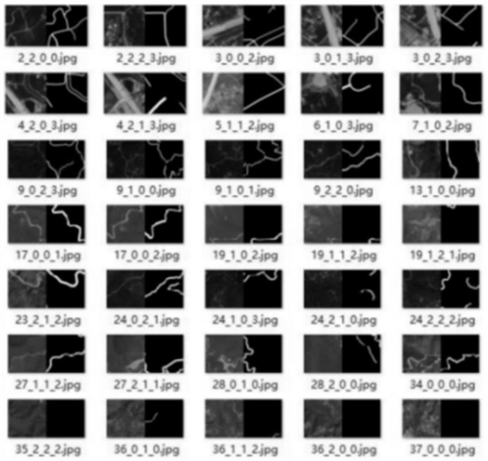
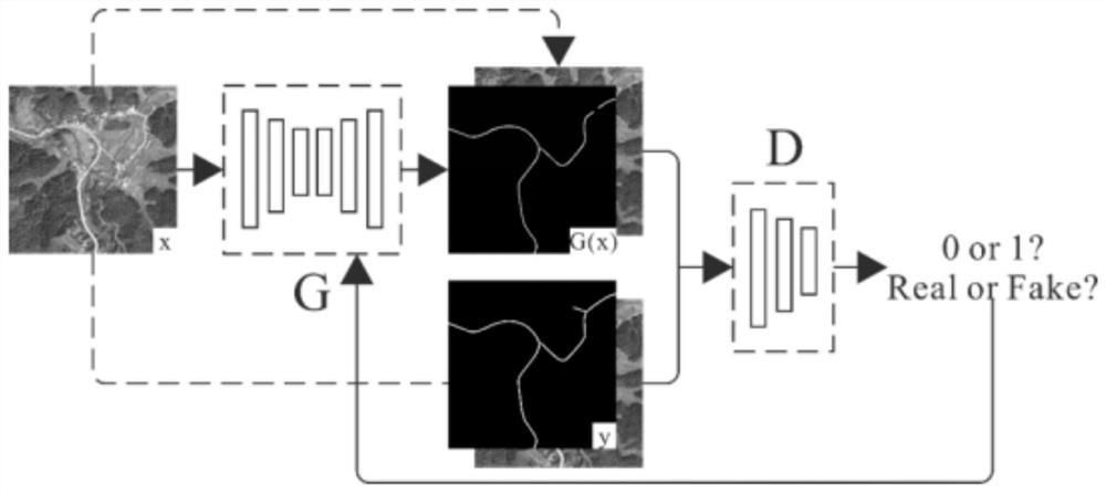
[0034] see Figure 1-6 , the road network verification technology based on high-resolution remote sensing images and deep learning methods, including four steps: sample set production, model training, road network extraction and road network verification. The specific operation steps are as follows:

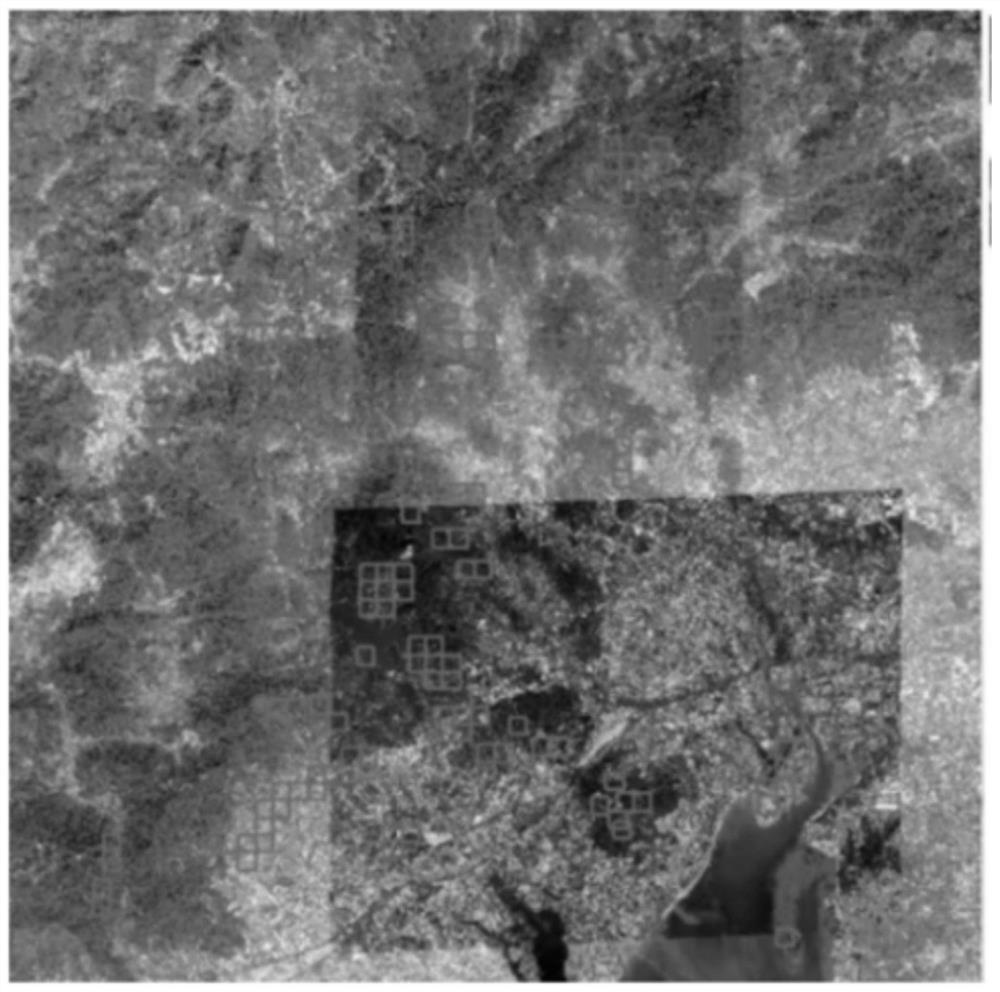
[0035] Step 1: Preparation of sample set: The data set used in the preparation of the sample set comes from the images of the Gaofen-2 satellite, which is the first civilian optical remote sensing satellite independently developed by my country with a spatial resolution better than 1 meter , equipped with a 1-meter-resolution panchromatic camera and a 4-meter-resolution multispectral camera, and has the characteristics of high precision, long life, and multiple angles; the cloud coverage of all images is less than 5%, and the imaging is clear to ensure...


PUM


Abstract

The invention discloses a road network checking technology based on a high-resolution remote sensing image and a deep learning method, which belongs to the technical field of road network checking and comprises four steps of sample set manufacturing, model training, road network extraction and road network checking. A data set used for making the sample set is derived from a Gaofen-2 satellite image; the model training comprises target function setting, target function optimization and iterative training; the road network extracts a road network grid binarization image, vectorizes the road network grid binarization image, and outputs a road network vector result; in the road network checking, a buffer area analysis method is used for judging the space matching relation of the two. The method greatly reduces the cost of manpower and material resources, has more advantages in extraction efficiency, extraction precision and universality, and is suitable for various landform environments.

Description

technical field [0001] The invention belongs to the technical field of road network verification, in particular to a road network verification technology based on high-resolution remote sensing images and deep learning methods. Background technique [0002] The large-scale construction and upgrading of the road network has greatly promoted the development of my country's transportation industry and economy, but at the same time it has put forward higher requirements for the comprehensive supervision of the road network. Especially for road network verification, traditional manual field verification is time-consuming and laborious, and the data collection cycle is too long to meet the current actual work needs. Therefore, more intelligent and automated technical means are urgently needed. [0003] The basis of road network verification is road network extraction. As an advanced means of earth observation, high-resolution (high-resolution) remote sensing can comprehensively, ...

Claims


Application Information

Patent Timeline
Patent Type & Authority Applications(China)
IPC IPC(8): G06K9/00G06K9/34G06K9/62G06N20/00
CPCG06N20/00G06V20/13G06V10/267G06F18/214G06F18/2415
Inventor 王九胜许辉柳立程向军李怡霏
Owner 甘肃省公路局
Why Eureka
Try Eureka