
GEO orbit precision evaluation method and device, electronic equipment and storage medium

A technology of accuracy evaluation and storage medium, applied in the field of satellite navigation and communication, it can solve the problems of large weather influence, few GEO satellites, and small number of SLR tracking stations, etc., to achieve the effect of wide application

Active Publication Date: 2021-06-08
NAT TIME SERVICE CENT CHINESE ACAD OF SCI
View PDF7 Cites 1 Cited by
  • Summary
  • Abstract
  • Description
  • Claims
  • Application Information

AI Technical Summary

Problems solved by technology

[0005] Existing methods for assessing the orbit accuracy outside GEO, such as SLR data residual evaluation, firstly require satellites to be equipped with laser retroreflector loads, and such GEO satellites are very few; secondly, even if GEO is equipped with laser retroreflectors, due to The number of SLR tracking stations is small, the observation is greatly affected by the weather, and other satellite observation tasks are heavy. The SLR observation data of GEO satellites are scarce, and the accuracy of satellite orbits cannot be finely evaluated.

Method used


Image

  • GEO orbit precision evaluation method and device, electronic equipment and storage medium
  • GEO orbit precision evaluation method and device, electronic equipment and storage medium
  • GEO orbit precision evaluation method and device, electronic equipment and storage medium

Examples


Embodiment 1

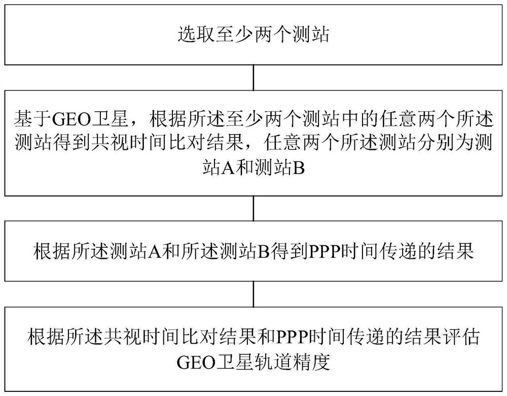
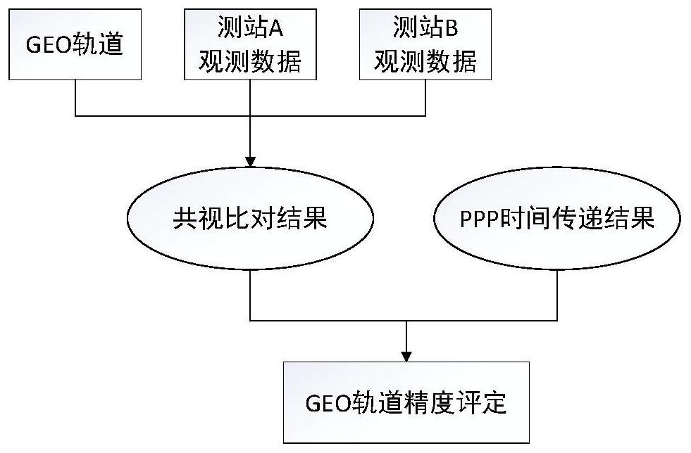
[0048] See figure 1 and figure 2 , figure 1 is a schematic flowchart of a GEO orbit accuracy evaluation method provided by an embodiment of the present invention, figure 2is a schematic flowchart of another GEO orbit accuracy evaluation method provided by an embodiment of the present invention. This embodiment provides a GEO orbit accuracy evaluation method, the GEO orbit accuracy evaluation method includes steps 1 to 4, wherein:

[0049] Step 1. Select at least two measuring stations.

[0050] Specifically, the measuring station in this embodiment may be a time reference station or a measuring station connected with an external high-precision atomic clock.

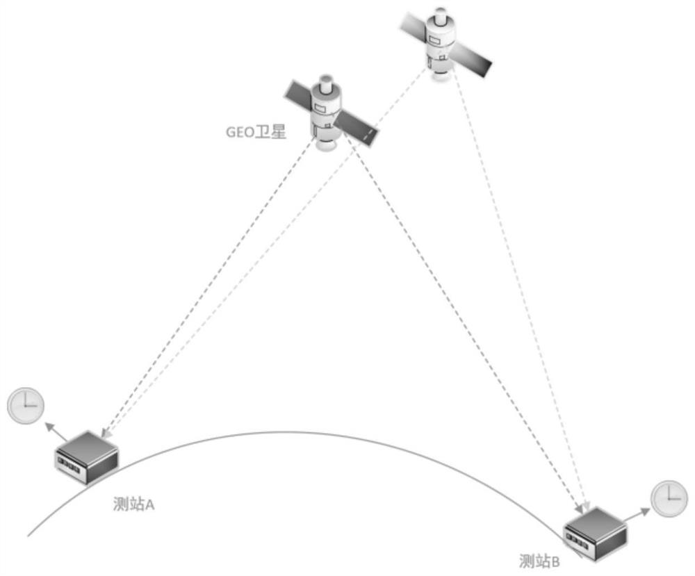
[0051] Step 2. Based on the GEO satellite, the common-view time comparison result is obtained according to any two stations in at least two stations. Any two stations are station A and station B. Please refer to image 3 Station A and Station B in .

[0052] Specifically, this embodiment performs a long-baseline G...

Embodiment 2

[0080] See Figure 4 , Figure 4 It is a structural schematic diagram of a GEO orbit accuracy evaluation device provided by an embodiment of the present invention. The GEO orbit accuracy evaluation device includes:

[0081] A selection module is used to select at least two stations;

[0082] The common-view time comparison module is used to obtain the common-view time comparison result based on any two stations in at least two stations based on the GEO satellite, and any two stations are station A and station B respectively;

[0083] The PPP time transfer module is used to obtain the result of PPP time transfer according to station A and station B;

[0084] The evaluation module is used to evaluate the GEO satellite orbit accuracy according to the common-view time comparison result and the PPP time transfer result.

[0085] In a specific embodiment, the common-view time comparison module is specifically used to obtain the difference between the first clock difference betwe...

Embodiment 3

[0094] See Figure 5 , Figure 5 It is a schematic structural diagram of an electronic device provided by an embodiment of the present invention. The electronic device 1100 includes: a processor 1101, a communication interface 1102, a memory 1103, and a communication bus 1104, wherein the processor 1101, the communication interface 1102, and the memory 1103 complete mutual communication through the communication bus 1104;

[0095] memory 1103, for storing computer programs;

[0096] The processor 1101 is configured to implement the above method steps when executing the computer program.

[0097] When the processor 1101 executes the computer program, the following steps are implemented:

[0098] Step 1. Select at least two stations;

[0099] Step 2. Based on the GEO satellite, the common-view time comparison result is obtained according to any two stations in at least two stations, and any two stations are respectively station A and station B;

[0100] Step 3, obtain the r...


PUM


Abstract

The invention discloses a GEO orbit precision evaluation method and device, electronic equipment and a storage medium. The evaluation method comprises the following steps: selecting at least two observation stations; based on a GEO satellite, acquiring a common-view time comparison result according to any two observation stations in the at least two observation stations, wherein the any two observation stations are an observation station A and an observation station B respectively; obtaining a PPP time transmission result according to the observation station A and the observation station B; and evaluating the GEO satellite orbit precision according to the common-view time comparison result and the PPP time transmission result. According to the GEO orbit precision evaluation method, long-baseline time comparison is carried out based on each GEO by using the observation station through a time comparison mode, and the comparison result is compared with the PPP time transmission result so that the GEO satellite orbit precision is evaluated, external coincidence evaluation can be carried out on the GEO satellite orbit precision, and support is provided for further improving the orbit determination strategy and improving the precision orbit determination level of the GEO navigation satellite.

Description

technical field [0001] The invention belongs to the technical field of satellite navigation and communication, and in particular relates to a GEO orbit accuracy evaluation method, device, electronic equipment and storage medium. Background technique [0002] GEO satellites, as geosynchronous orbit satellites and sustainable observation stations, were initially widely used in the field of communication. With the development of aerospace technology, GEO satellite orbit has become an important orbital resource in communication, meteorology, reconnaissance, navigation and positioning, timing and earth science research due to its unique high-orbit and geostationary characteristics. And as its role in resources, navigation and timing, and earth science and other economic and military aspects increases, the accuracy requirements for its orbit itself are getting higher and higher. [0003] At present, in the field of navigation, GEO satellites not only provide navigation and timing...

Claims


Application Information

Patent Timeline
Patent Type & Authority Applications(China)
IPC IPC(8): G01S19/20H04B7/185
CPCG01S19/20H04B7/18519
Inventor 王源昕孙保琪张喆杨旭海武美芳王格苏行杨海彦
Owner NAT TIME SERVICE CENT CHINESE ACAD OF SCI
Learn More