

Three-dimensional dynamic loading method and device for raster data
A raster data, three-dimensional dynamic technology, applied in the field of natural resource information statistics, can solve problems such as not satisfying large-scale slope calculation and analysis, unable to calculate different elevation zones, slope zone distribution, and not supporting raster data calculation and analysis
- Summary
- Abstract
- Description
- Claims
- Application Information
AI Technical Summary
Problems solved by technology
Method used
Image


Examples
Embodiment 1
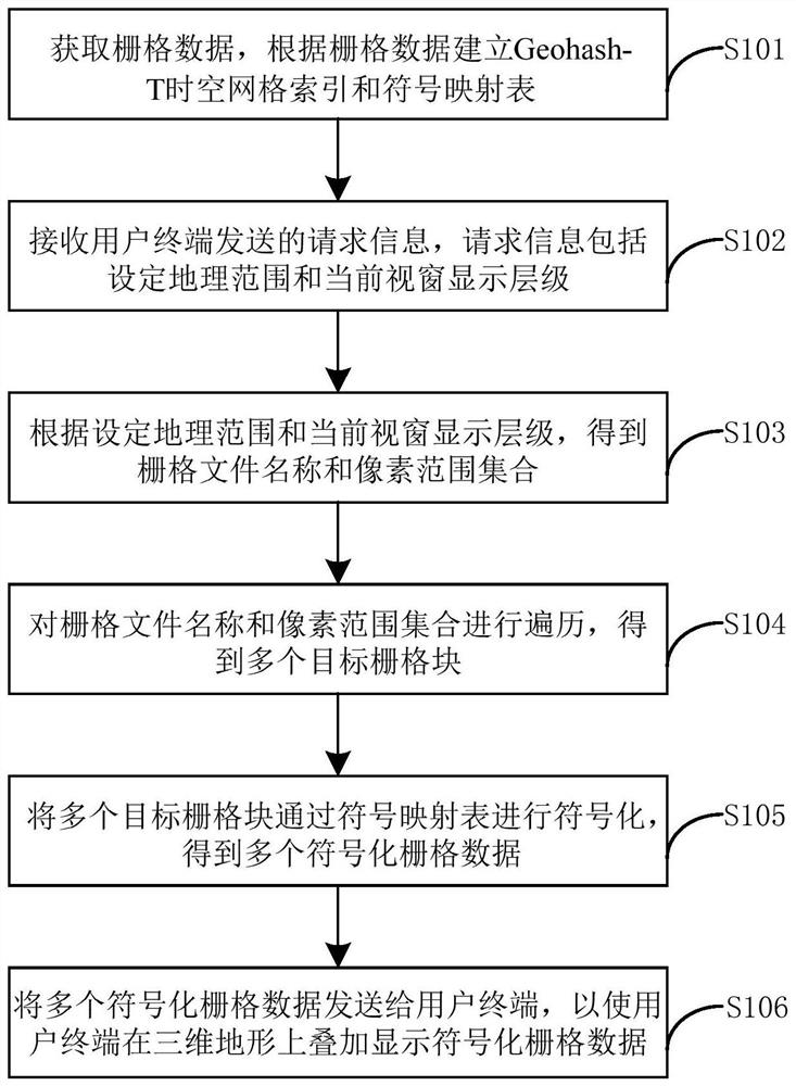
[0055] figure 1 This is a flow chart of the method for 3D dynamic loading of grid data provided in Embodiment 1 of the present invention.
[0056] refer to figure 1 , the execution body is the server, and the method includes the following steps:
[0057]Step S101, obtaining grid data, and establishing a Geohash-T spatiotemporal grid index and a symbol mapping table according to the grid data;
[0058] Step S102, receiving request information sent by the user terminal, where the request information includes the set geographic scope and the current window display level;
[0059] Here, the user terminal refers to the 3D map engine at the front end of the computer or mobile phone. The Geohash-T spatiotemporal grid index is used to organize the raster data in an orderly manner, and a timestamp is used to identify the time information of the raster data.
[0060] The Geohash-T encoding rule is: Geohash encoding + 8-bit time encoding, for example, 1110011101001000111120160103, wh...
Embodiment 2
[0094] Figure 4 It is a schematic diagram of a three-dimensional dynamic loading device for grid data provided by the second embodiment of the present invention.
[0095] refer to Figure 4 , applied to the server, including:
[0096] Establishing unit 1, for obtaining grid data, and establishing Geohash-T spatiotemporal grid index and symbol mapping table according to the grid data;
[0097] a receiving unit 2, configured to receive request information sent by the user terminal, where the request information includes a set geographic scope and a current window display level;
[0098] The pixel range set acquisition unit 3 is used to obtain the raster file name and the pixel range set according to the set geographic range and the current window display level;
[0099] Traversing unit 4, used to traverse the grid file name and pixel range set to obtain multiple target grid blocks;
[0100] The symbolizing unit 5 is used to symbolize a plurality of target grid blocks throug...
PUM
 Abstract
Description
Claims
Application Information