
Remote Sensing Retrieval Method of Surface High Resolution Spectral Information Based on Radiosity

A high-resolution spectral and remote sensing inversion technology, which is applied in the field of optimization and inversion of complex surface high-resolution optical waveband remote sensing signals, and can solve the problems of not considering the effect of multiple scattering of surface three-dimensional structures.

Active Publication Date: 2021-09-24
AEROSPACE INFORMATION RES INST CAS
View PDF19 Cites 0 Cited by
  • Summary
  • Abstract
  • Description
  • Claims
  • Application Information

AI Technical Summary

Problems solved by technology

[0004] To sum up, the existing high-spatial-resolution inversion algorithms and products do not consider the multiple scattering effects of the three-dimensional surface structure, resulting in uncertainty in the inversion results of surface temperature and reflectivity. Therefore, based on the three-dimensional radiosity theory, with radiation balance and remote sensing observations as constraints, a high spatial resolution surface temperature and albedo inversion method considering the effect of multiple scattering is proposed

Method used


Image

  • Remote Sensing Retrieval Method of Surface High Resolution Spectral Information Based on Radiosity
  • Remote Sensing Retrieval Method of Surface High Resolution Spectral Information Based on Radiosity
  • Remote Sensing Retrieval Method of Surface High Resolution Spectral Information Based on Radiosity

Examples


Embodiment Construction

[0037] The present invention will be further described in detail below in conjunction with the accompanying drawings and specific embodiments.

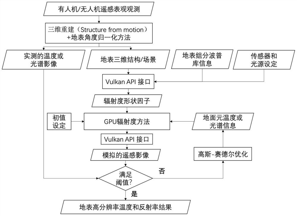
[0038] Such as figure 1 The radiometric-based remote sensing retrieval method for high-resolution spectral information on the surface includes the following steps:

[0039] S1, 3D scene reconstruction;

[0040] The 3D unmanned aerial vehicle / manned machine observation platform obtains a series of remote sensing images, and then performs 3D reconstruction of the surface through the method of 3D reconstruction of 2D moving images (Structure from motion) to obtain the 3D structure information of the surface and its corresponding spectrum or temperature information; The steps are the pre-steps for eliminating multiple scattering items in the observation results. The processing steps of the SFM method include: image alignment, sparse point cloud construction, dense point cloud construction, grid construction, digital elevation (DEM) const...


PUM


Abstract

The invention discloses a remote sensing inversion method for surface high-resolution spectral information based on irradiance, comprising the following steps: S1, three-dimensional scene reconstruction; S2, angle normalization; S3, setting sensors and light sources; S4, calculating shape Factor; S5, set temperature and initial value of reflectivity; S6, output simulated image through GPU fast radiosity method; S7, threshold judgment; S8, optimize temperature and reflectivity of surface element; S9, end process and output result. The present invention fully considers the influence of multiple scattering on the ground surface, so that the temperature and reflectance results of the inversion are both stable and accurate; the strategy based on GPU instead of CPU makes the present invention more practical for inversion, and this method is expected to become Effective tool for high-resolution surface temperature and albedo production from drones or manned aircraft.

Description

technical field [0001] The invention relates to an iterative inversion algorithm, in particular to an optimized inversion method for complex surface high-resolution optical band remote sensing signals (temperature and reflectivity). Background technique [0002] With the rapid development of high spatial resolution satellite and UAV technology, the application of high spatial resolution remote sensing images is becoming more and more extensive. Compared with the existing low-spatial-resolution data, high-spatial-resolution data can provide more detailed spatial information of the surface and its corresponding spectrum or temperature information, and can be used in agricultural production estimation, urban planning, urban heat island, environmental protection, drought and fire monitoring. In other fields, high spatial resolution remote sensing has gradually become an important data source for research and application. [0003] Previous remote sensing retrieval algorithms and...

Claims


Application Information

Patent Timeline
Patent Type & Authority Patents(China)
IPC IPC(8): G06T17/00G06F17/11G01N21/55G01N21/25G01K11/00
CPCG01K11/006G01N21/25G01N21/55G06F17/11G06T17/00
Inventor 卞尊健李嘉昕范腾远曹彪历华杜永明肖青柳钦火
Owner AEROSPACE INFORMATION RES INST CAS
Learn More