
Optical remote sensing image registration method and system combining SIFT point and control line pair

An optical remote sensing image, control line pair technology, applied in image enhancement, image analysis, image data processing and other directions, can solve problems such as difficult one-to-one correspondence, complicated selection of constraints, and short computing time.

Pending Publication Date: 2021-07-09
XI AN JIAOTONG UNIV
View PDF3 Cites 0 Cited by
  • Summary
  • Abstract
  • Description
  • Claims
  • Application Information

AI Technical Summary

Problems solved by technology

Stamos I. et al. proposed to use the slope of the feature line and the distribution of the edge profile to obtain the registration parameters, but when there are multiple lines with approximate slopes, it is not easy to achieve one-to-one correspondence, and it is inevitable to cause mismatching
Kim Y.S. et al. used point features and edge feature direction information for registration, but used the Canny operator for the original remote sensing image and visible light image, and did not take into account the characteristics of remote sensing images that are susceptible to noise
Su Juan et al. used the straight line features of the image to construct control points, designed a function based on the matching degree of control points, realized automatic registration from coarse to fine, and achieved good results, but it took a long time and was difficult to apply to real-time strong application
Li Ying et al. used three straight-line edges as a reference model to construct a candidate matching set under certain constraints, and determined the correspondence between straight-line edges on this basis. The experimental results showed that the calculation time was short, but the selection of constraints was complicated. Did not come up with a universally applicable reference, and when straight edges are similar in position, orientation, and length, they are prone to mismatches, and more constraints need to be introduced
[0007] To sum up, most feature-based image registration algorithms at this stage use a single feature. Although this type of algorithm shortens the running time, it is not robust to remote sensing images with a lot of noise.

Method used


Image

  • Optical remote sensing image registration method and system combining SIFT point and control line pair
  • Optical remote sensing image registration method and system combining SIFT point and control line pair
  • Optical remote sensing image registration method and system combining SIFT point and control line pair

Examples


Embodiment Construction

[0073] In order to make the purpose, technical effects and technical solutions of the embodiments of the present invention more clear, the technical solutions in the embodiments of the present invention are clearly and completely described below in conjunction with the accompanying drawings in the embodiments of the present invention; obviously, the described embodiments It is a part of the embodiment of the present invention. Based on the disclosed embodiments of the present invention, other embodiments obtained by persons of ordinary skill in the art without making creative efforts shall all fall within the protection scope of the present invention.

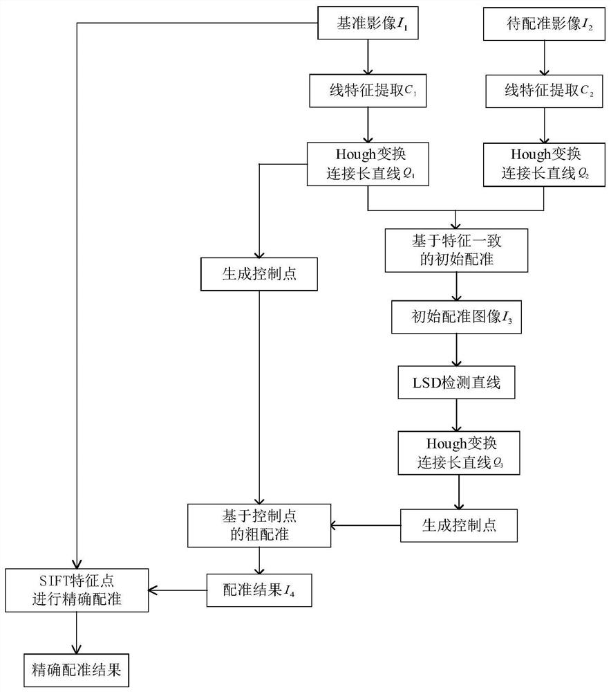
[0074] see figure 1 , a visible light remote sensing image registration method combining SIFT points and control line pairs according to an embodiment of the present invention, comprising the following steps:

[0075] Step 1: Use the LSD algorithm to extract the reference image I 1 and the image to be registered I 2 The set ...


PUM


Abstract

The invention discloses an optical remote sensing image registration method and system in combination with SIFT points and control line pairs. The method comprises the following steps: respectively obtaining linear feature sets of a reference image and an image to be registered; obtaining an initial registration image based on the linear feature set of the reference image and the linear feature set of the to-be-registered image; acquiring a linear feature set of the initial registration image; respectively counting intersecting straight line pairs in the straight line feature set of the reference image and the straight line feature set of the initial registration image to obtain a statistical result, and obtaining a candidate matching set based on the statistical result; obtaining a coarse registration result based on the candidate matching set; and obtaining an accurate registration result of the reference image and the coarse registration image by using an SIFT key point registration algorithm, and completing optical remote sensing image registration. The method is high in speed and good in robustness, and registration of visible light remote sensing images with typical linear targets can be achieved.

Description

technical field [0001] The invention belongs to the field of aerospace technology and relates to the field of optical remote sensing image registration, in particular to an optical remote sensing image registration method and system combining SIFT points and control line pairs. Background technique [0002] In aerospace research, a wealth of ground remote sensing data can be obtained by using aerospace vehicles at different heights. Remote sensing data is widely used in many fields due to its timeliness and practicability, such as battlefield detection, aircraft navigation, UAV landing and horizon detection, etc. The rapid development of satellite remote sensing technology has led to a sharp increase in the amount of space and space remote sensing data. How to use massive space and space remote sensing data to meet different production and living needs has become one of the outstanding problems faced by remote sensing applications. Information fusion can make comprehensive ...

Claims


Application Information

Patent Timeline
IPC IPC(8): G06T7/33
CPCG06T7/33G06T2207/10032G06T2207/20061
Inventor 杨艺张猛张思贤米鹏博蒋庆华
Owner XI AN JIAOTONG UNIV
Learn More