
Method for determining carbon monoxide emission flux of environmental atmospheric pollution point source based on satellite remote sensing

A carbon monoxide and satellite remote sensing technology, which is applied in the methods of obtaining spatial resolution, measuring devices, and material analysis by optical means, and can solve the problems of lack of high-density stereoscopic observation data and lack of high precision.

Active Publication Date: 2021-08-20
ANHUI UNIVERSITY
View PDF7 Cites 4 Cited by
  • Summary
  • Abstract
  • Description
  • Claims
  • Application Information

AI Technical Summary

Problems solved by technology

[0003] In order to overcome the existing lack of high-density stereoscopic observation data and lack of high-precision industrial point source emission monitoring methods, the present invention provides a method for determining carbon monoxide emission flux from ambient air pollution point sources based on satellite remote sensing

Method used


Image

  • Method for determining carbon monoxide emission flux of environmental atmospheric pollution point source based on satellite remote sensing
  • Method for determining carbon monoxide emission flux of environmental atmospheric pollution point source based on satellite remote sensing
  • Method for determining carbon monoxide emission flux of environmental atmospheric pollution point source based on satellite remote sensing

Examples


Embodiment Construction

[0019] The present invention will be described in detail below in conjunction with the accompanying drawings and specific embodiments. But following embodiment only limits to explain the present invention, and protection scope of the present invention should comprise the whole content of claim, and by the narration of following embodiment, those skilled in the art can fully realize the whole content of claim of the present invention.

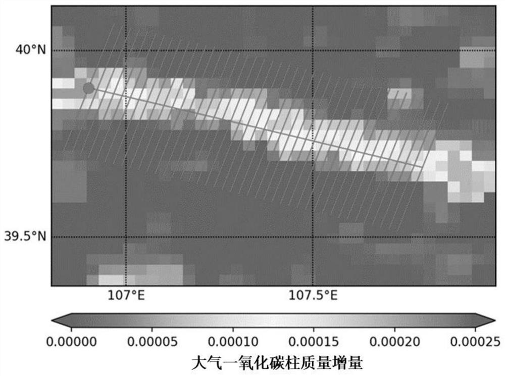
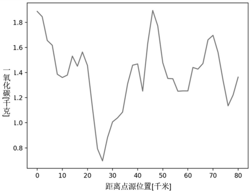
[0020] Using the spatial and temporal distribution of carbon monoxide observed by high-resolution satellite remote sensing combined with fine wind field information to accurately identify and quantify the point source plume emission flux. Due to the effect of the wind field, the industrial point source carbon monoxide plume plume of satellite remote sensing will present various shapes. The present invention uses the cross-sectional integral flux method to quantify the industrial point source emission flux, that is, the integrated plume along the ...


PUM


Abstract

The invention discloses a method for determining the carbon monoxide emission flux of an environmental atmospheric pollution point source based on satellite remote sensing. On the basis of spatial and temporal distribution of carbon monoxide atmosphere observed by satellite remote sensing, smoke plumes emitted by a point source are identified and quantified by adopting a section integrated flux algorithm according to wind field information. According to the method, the carbon monoxide emission flux of an industrial source and the uncertainty and the long-time change rule of the carbon monoxide emission flux are calculated by using a section integrated flux algorithm. The transmission scale, the spatial distribution rule and the space-time evolution characteristics of the carbon monoxide emission of an industrial source can be obtained by combining atmospheric circulation, meteorological elements, topography and landform and source area pollution characteristics. Compared with a traditional emission flux quantification method, the section integrated flux algorithm based on satellite remote sensing can realize high-precision calculation of the emission flux of a point source in any region, and has important significance in the field of accurate prevention and control of atmospheric pollution.

Description

technical field [0001] The invention belongs to the technical field of environmental impact assessment, and relates to a method for determining the emission flux of carbon monoxide from a point source of environmental air pollution based on satellite remote sensing, especially capable of identifying and quantifying the emission flux of a point source in any region. Background technique [0002] Carbon monoxide is one of the six basic control pollutants in my country's "Ambient Air Quality Standards". At present, there are bottleneck problems in the observation of atmospheric pollutant carbon monoxide, such as the lack of high-density stereoscopic observation data, the lack of high-precision industrial point source emission monitoring methods, and the lack of high-efficiency evaluation and optimization methods. It makes the calculation of pollutant gas carbon monoxide transport and emission flux difficult. How to construct a high-precision industrial point source emission fl...

Claims


Application Information

Patent Timeline
IPC IPC(8): G01N21/17G01N21/3504
CPCG01N21/17G01N21/3504G01N2021/1795G01N2021/178
Inventor 田园
Owner ANHUI UNIVERSITY
Learn More