Supercharge Your Innovation With Domain-Expert AI Agents!

Automatic three-dimensional modeling measurement method based on oblique photography of unmanned aerial vehicle

A technology of oblique photography and three-dimensional modeling, applied in 3D modeling, photo interpretation, instruments, etc., can solve the problems of unsatisfactory measurement results and cost, labor-intensive, long cycle, etc., to achieve reconstruction and export, Time-saving and low-cost effects

Pending Publication Date: 2021-08-24
TAIZHOU UNIV
View PDF0 Cites 3 Cited by
  • Summary
  • Abstract
  • Description
  • Claims
  • Application Information

AI Technical Summary

Problems solved by technology

[0002] With the continuous improvement of measurement technology in our country, people have higher requirements for the accuracy of measurement results and measurement cost; at present, the field measurement method of GPS-RTK and total station is usually used for rural homestead measurement, and the disadvantages of this method It takes a lot of manpower to carry out field measurements, and the efficiency is low, the cycle is long, and the cost is high. The measurement results and costs are not very ideal. Therefore, a measurement method that can save material and manpower is needed. Compared with the traditional The method reduces the investment and improves the efficiency of the measurement method. Therefore, a new automatic 3D modeling measurement method based on UAV oblique photography is proposed. After the UAV photogrammetry, the image is quickly and automatically generated. The generated 3D model replaces the field measurement, which saves time and cost, has high efficiency, low cost and accurate data. It is currently applied to the "Rural Real Estate Integrated Real Estate Registration" project, and can also be used in smart cities, urban planning, illegal construction, emergency Widely used in technical fields such as monitoring, earthquake mitigation and disaster relief

Method used


Image

  • Automatic three-dimensional modeling measurement method based on oblique photography of unmanned aerial vehicle
  • Automatic three-dimensional modeling measurement method based on oblique photography of unmanned aerial vehicle

Examples


Embodiment Construction

[0033] The specific technical solutions of the present invention will be further described below with reference to the accompanying drawings, so that scholars and technical personnel in the field can further understand the present invention, without constituting a limitation on the rights of the present invention.

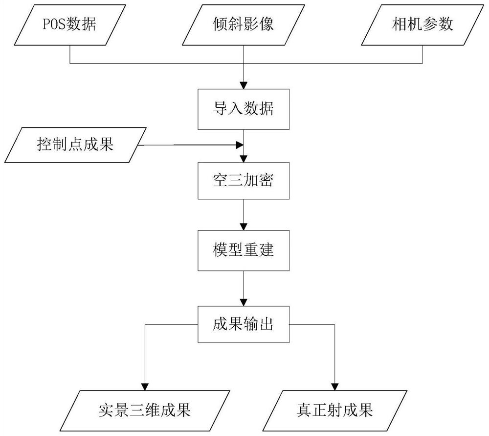
[0034] This embodiment discloses an automatic three-dimensional modeling measurement method based on UAV oblique photography. The measurement method includes the following steps: extracting images and image measurement data through UAV oblique photography; importing the obtained data, that is, photo data into the global After the automatic modeling processing system, the three-dimensional modeling of the real space is obtained, so as to obtain the data that needs to be measured or calculated. The automatic modeling system is compatible with a variety of office acquisition software formats.

[0035] combine figure 1 with figure 2 , the specific operation steps of ...


PUM


Abstract

The invention discloses an automatic three-dimensional modeling measurement method based on oblique photography of an unmanned aerial vehicle. The method comprises the following steps: extracting an image and image measurement data through oblique photography of the unmanned aerial vehicle; importing the obtained data into an automatic modeling processing system to obtain a spatial live-action three-dimensional model; therefore, data needing to be measured or calculated are obtained; according to the method, the multi-angle high-resolution image can be conveniently and flexibly acquired, the live-action three-dimensional model can be quickly and automatically generated, geographic element acquisition can be performed indoors based on the live-action three-dimensional model, field actual measurement is replaced, time is saved, and the method has the characteristics of high efficiency, low cost, accurate data and the like.

Description

technical field [0001] The invention belongs to the field of UAV photogrammetry, in particular to an automatic three-dimensional modeling measurement method based on UAV oblique photography. Background technique [0002] With the continuous improvement of measurement technology in our country, people have higher requirements for the accuracy of measurement results and measurement cost; at present, the field measurement method of GPS-RTK and total station is usually used for rural homestead measurement, and the disadvantages of this method It takes a lot of manpower to carry out field measurements, and the efficiency is low, the cycle is long, and the cost is high. The measurement results and costs are not very ideal. Therefore, a measurement method that can save material and manpower is needed. Compared with the traditional The method reduces the investment and improves the efficiency of the measurement method. Therefore, a new automatic 3D modeling measurement method based ...

Claims


Application Information

Patent Timeline
IPC IPC(8): G06T17/10G06T17/20G01C11/34
CPCG01C11/34G06T17/10G06T17/20
Inventor 钟美徐德军
Owner TAIZHOU UNIV
Features
  • R&D
  • Intellectual Property
  • Life Sciences
  • Materials
  • Tech Scout
  • Unparalleled Data Quality
  • Higher Quality Content
  • 60% Fewer Hallucinations
Learn More