Navigation method and system based on environmental target detection and environmental target map

A target detection and target technology, which is applied in the field of navigation methods and systems based on environmental target detection and environmental target maps, can solve problems such as large position errors, and achieve the effects of ensuring safe operation and facilitating deployment and implementation.

Active Publication Date: 2021-09-07
XI AN JIAOTONG UNIV
View PDF11 Cites 6 Cited by
  • Summary
  • Abstract
  • Description
  • Claims
  • Application Information

AI Technical Summary

Problems solved by technology

The traditional positioning based on target detection uses the position information of the target as the position of the photographer, which is essentially a kind of proximity positioning, and there is a large position error

Method used


Image

  • Navigation method and system based on environmental target detection and environmental target map
  • Navigation method and system based on environmental target detection and environmental target map
  • Navigation method and system based on environmental target detection and environmental target map

Examples


Embodiment Construction

[0042] Next, the technical solutions in the embodiments of the present invention will be described in contemplation in the embodiment of the present invention, and it is clear that the described embodiments are intended to be in an embodiment of the invention, not all of the embodiments of the invention. Based on the embodiments of the present invention, there are all other embodiments obtained without making creative labor without making creative labor premises.

[0043] It should be understood that when used in this specification and the appended claims, the terms "include" and "including" indicating the description of the features, overall, steps, operations, elements, and / or components, but does not exclude one or Multiple other features, overall, steps, operations, elements, components, and / or their set presence or addition.

[0044] It should also be understood that the terms used in the specification of the present invention are merely the purposes of describing the par...


PUM


Abstract

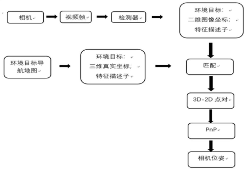
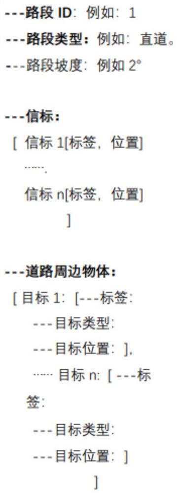
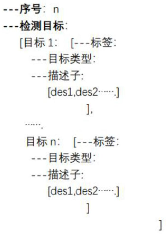
The invention discloses a navigation method and system based on environmental target detection and an environmental target map. The method comprises the steps of constructing an environmental target navigation electronic map used for assisting driving and positioning, defining the content needing to be stored in the electronic map, carrying out the measurement and modeling of the three-dimensional real coordinates of an environmental target and a road, designing an electronic map data structure, acquiring a video frame image in a vehicle advancing process, and performing target detection on the acquired video frame image by using a mode recognition method to obtain the type of an environmental target and a two-dimensional image coordinate, extracting a feature descriptor of the type of an environmental target and a two-dimensional image coordinate through a feature extraction operator, matching the type of the environmental target and the two-dimensional image coordinate with a target stored in an environmental target navigation electronic map based on the feature descriptor to obtain a 3D-2D point pair, and calculating through a PnP method to obtain a current pose of a vehicle so as to realize positioning, and realizing environmental target navigation. The method is high in positioning precision, easy to implement and low in cost, and has wide application value.

Description

Technical field [0001] The present invention belongs to the technical field of automatic driving, particularly relates to a navigation method and system for target detection based on the environment map and environmental objectives. Background technique [0002] Currently, traffic safety issues has been more and more attention. Among them, the front obstacle on road safety vehicle constitutes a very serious threat. Driving rely only driver to determine whether there is an obstacle ahead, the brakes to slow down, to avoid the current situation of traffic accidents, has far unable to meet the needs of vehicle safety, so the obstacle recognition technology and sensor fusion technology for a vehicle in front of obstacles probe was of great practical significance. [0003] Visible light camera provides higher resolution images and richer detail, can support the recognition site name, kilometer mark, lights and other markers may be used to assist in driving and navigation. Driver assis...

Claims


Application Information

Patent Timeline
Patent Type & Authority Applications(China)
IPC IPC(8): G01C21/32G01C21/00
CPCG01C21/32G01C21/3837Y02T10/40
Inventor 牟轩沁田锦张跃廖谦
Owner XI AN JIAOTONG UNIV
Why Eureka
Try Eureka