Unmanned aerial vehicle line patrol path planning method and system

A track planning and unmanned aerial vehicle technology, applied in control/adjustment system, three-dimensional position/course control, vehicle position/route/altitude control, etc., can solve the problems of cumbersome control process of unmanned aerial vehicle and low efficiency of line inspection , to achieve the effect of shortening inspection time, improving line inspection efficiency and improving work efficiency

Active Publication Date: 2021-09-07
ORDOS VOCATIONAL COLLEGE
View PDF9 Cites 1 Cited by
  • Summary
  • Abstract
  • Description
  • Claims
  • Application Information

AI Technical Summary

Problems solved by technology

[0005] Based on this, it is necessary to solve the problems that UAVs need to perform manual flight control when performing power line inspection tasks, and the UAV control process is cumbersome, and the line inspection efficiency is not high; provide a UAV line inspection track planning method and Its system realizes the automatic line inspection of drones

Method used


Image

  • Unmanned aerial vehicle line patrol path planning method and system
  • Unmanned aerial vehicle line patrol path planning method and system
  • Unmanned aerial vehicle line patrol path planning method and system

Examples


Embodiment 1

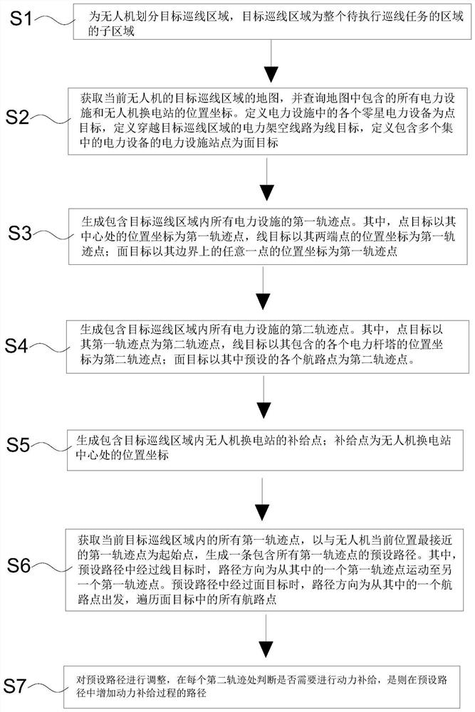
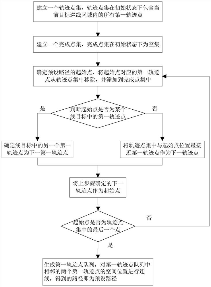
[0070] This embodiment provides a method for planning a UAV patrol line, such as figure 1 As shown, the planning method includes the following steps:

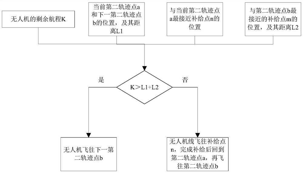
[0071] S1: Divide the target line inspection area for the UAV, and the target line inspection area is a sub-area of ​​the entire area where the line inspection task is to be performed. In a practical application scenario, the entire area where line inspection tasks are to be performed is usually relatively large, and there are a large number of power facilities distributed in the entire area. These power equipment specifically include substations, substations, switchgears, switch cabinets, transformers, overhead medium and high voltage transmission lines, poles or towers installed at intervals in the transmission lines, and so on. These electrical equipment are the facilities that actually need to be inspected in the process of performing line inspection tasks. Considering the limitation of the cruising ability of UAVs during...

Embodiment 2

[0114] This embodiment provides a UAV patrol line track planning system, the planning system uses the UAV patrol line track planning method as described in Embodiment 1 to generate its own flight path; Figure 4 As shown, the planning system includes: a map acquisition module, a first trajectory point generation module, a second trajectory point generation module, a preset path generation module, a battery replacement discrimination module, and a real path control module.

[0115] Among them, the map acquisition module is used to obtain the map of the target line inspection area that the UAV is responsible for patrolling. The map contains the position coordinates of all power facilities and UAV switching stations in the target line inspection area.

[0116] The first trajectory point generation module is used to obtain all the first trajectory points in the target line inspection area; define each sporadic power equipment in the power facility as a point target; define the powe...


PUM


Abstract

The invention relates to the field of unmanned aerial vehicle flight control, in particular to an unmanned aerial vehicle line patrol route planning method and system. The method comprises the following steps: S1, dividing a target line patrol area for an unmanned aerial vehicle; S2, acquiring a map of the target line patrol area of the current unmanned aerial vehicle, and querying position coordinates of all electric power facilities and an unmanned aerial vehicle battery swap station contained in the map; S3, generating a first track point containing all the electric power facilities in the target line patrol area; S4, generating a second track point containing all the electric power facilities in the target line patrol area; S5, generating a supply point including the unmanned aerial vehicle battery swap station in the target line patrol area; S6, generating a preset path containing all the first track points in the current target line patrol area; S7, judging whether the unmanned aerial vehicle needs power supply or not so as to adjust the preset path. The problems that when an existing unmanned aerial vehicle executes an electric power line patrol task, manual flight control needs to be carried out, the control process of the unmanned aerial vehicle is tedious, and the line patrol efficiency is not high are solved.

Description

technical field [0001] The invention relates to the field of unmanned aerial vehicle flight control, in particular to a method and system for planning a patrol line of an unmanned aerial vehicle. Background technique [0002] During the use of power equipment, regular inspections are required to detect potential safety hazards in time, and then eliminate hidden dangers to ensure the stability of power consumption for power users. Existing power equipment line inspection tasks are mainly completed manually, and managers inspect all power facilities in their respective jurisdictions. [0003] With the development of UAV technology, UAVs are increasingly used in power line inspections. When using UAVs to inspect all power facilities in the jurisdiction, managers only need to control the relevant UAVs. It is only necessary to fly according to the required inspection path, without actually entering various locations within the jurisdiction, which greatly reduces the workload of ...

Claims


Application Information

Patent Timeline
Patent Type & Authority Applications(China)
IPC IPC(8): G05D1/10
CPCG05D1/101
Inventor 李波贺长春屈原
Owner ORDOS VOCATIONAL COLLEGE
Why Eureka
Try Eureka