Multi-feature fusion IGV positioning and mapping method based on 3D laser radar

A technology of multi-feature fusion and laser radar, applied in 2D image generation, image enhancement, image analysis, etc., can solve problems such as hidden safety hazards, increased economic costs, difficult high-precision positioning and mapping, etc., to achieve stability and speed The effect of operation

Pending Publication Date: 2021-09-17
HANGZHOU DIANZI UNIV
View PDF0 Cites 10 Cited by
  • Summary
  • Abstract
  • Description
  • Claims
  • Application Information

AI Technical Summary

Problems solved by technology

[0002] With the development of warehousing and logistics, our country has shifted from a labor-based low-end manufacturing industry to an artificial intelligence technology industry. Factors such as insufficient labor supply have prompted the continuous development of the mobile robot industry. In the future, China will become a big country in the manufacturing and application of mobile robots. .At present, most of the IGVs widely used in rush logistics use 2D laser slam as the positioning and mapping method. When the environment is symmetrical, it is difficult to achieve high-precision positioning and mapping, and only obtain flat map information. For navigation, avoidance Additional sensors need to be added to prevent obstacles, which not only increases economic costs, but also poses certain safety hazards

Method used


Image

  • Multi-feature fusion IGV positioning and mapping method based on 3D laser radar
  • Multi-feature fusion IGV positioning and mapping method based on 3D laser radar
  • Multi-feature fusion IGV positioning and mapping method based on 3D laser radar

Examples


Embodiment Construction

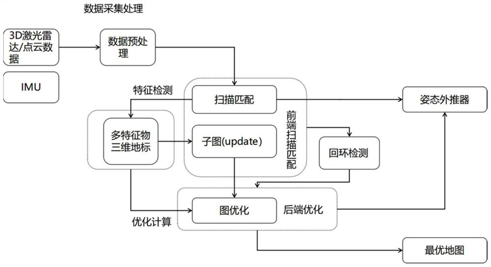
[0052] The execution steps of the method will be further described in detail below with reference to the accompanying drawings, but the protection scope of the present invention is not limited to the following description.

[0053] Such as figure 1 As shown, the present invention provides a multi-feature fusion IGV positioning and mapping method based on 3D lidar, which enables IGV to achieve high-precision positioning and mapping in complex environments. Specifically include the following steps:

[0054] S1: Divide the entire map scene into several cubes of similar size, assign a certain probability value to each cube, and assign a probability value of 1 to the three-dimensional landmark area, and construct a three-dimensional occupancy grid map. In the grid map, record laser hit as hit and miss as miss, use p(s=1) to represent the probability of its miss, use p(s=0) to represent the probability of its hit, and the difference between the two and 1.

[0055] Use the ratio o...


PUM


Abstract

The invention discloses a multi-feature fusion IGV positioning and mapping method based on a 3D laser radar. The method mainly comprises four processes of data acquisition processing, scanning matching and local map construction, back-end optimization and loopback detection. Data acquisition processing is data processing of the 3D laser radar sensor; according to the scanning matching and local map construction, a frame-subgraph matching mode is adopted for processed laser point cloud data, a three-dimensional landmark with multi-feature information such as angle, distance and reflection intensity is used for resolving an initial pose, and a local optimal subgraph is constructed by occupying a grid map; according to back-end optimization, for continuously iterated sub-graphs, a graph optimization strategy is adopted, an optimization problem is solved by using a Gaussian Newton method, and a solving process is accelerated by using a three-dimensional landmark, so that accumulated errors are eliminated; all tracks are stored in loopback detection, a multi-resolution map is adopted, calculation is accelerated through a branch and bound method, and closed-loop detection is completed. Finally, high-precision positioning and mapping of the AGV are realized.

Description

technical field [0001] The invention belongs to the field of automatic control, and in particular relates to a multi-feature fusion IGV positioning and mapping method based on 3D laser radar. Background technique [0002] With the development of warehousing and logistics, our country has shifted from a labor-based low-end manufacturing industry to an artificial intelligence technology industry. Factors such as insufficient labor supply have prompted the continuous development of the mobile robot industry. In the future, China will become a big country in the manufacturing and application of mobile robots. .At present, most of the IGVs widely used in rush logistics use 2D laser slam as the positioning and mapping method. When the environment is symmetrical, it is difficult to achieve high-precision positioning and mapping, and only obtain flat map information. For navigation, avoidance Additional sensors need to be added to prevent obstacles, which not only increases economic...

Claims


Application Information

Patent Timeline
Patent Type & Authority Applications(China)
IPC IPC(8): G06T11/00G06K9/62G06T5/00G06T7/70
CPCG06T11/00G06T7/70G06T5/002G06T2207/10028G06F18/253
Inventor 马啸林志赟韩志敏王博
Owner HANGZHOU DIANZI UNIV
Why Eureka
Try Eureka