Fire monitoring network positioning method based on RSSI ranging

A technology for monitoring networks and positioning methods, which is applied to services based on location information, network topology, wireless communication, etc. Monitoring and positioning, reducing positioning overhead, and the effect of small communication overhead

Pending Publication Date: 2021-09-28
HUAIYIN INSTITUTE OF TECHNOLOGY
View PDF0 Cites 2 Cited by
  • Summary
  • Abstract
  • Description
  • Claims
  • Application Information

AI Technical Summary

Problems solved by technology

However, the RSSI ranging method is greatly affected by the environment, so the nonlinear modeling of wireless signal propagation causes the positioning problem to appear as a nonlinear estimation problem
The RF wireless communication modeling ranging with additional redundant information is beneficial to the improvement of positioning accuracy. Therefore, under appropriate application conditions, RSSI is a cost-effective ranging and positioning solution. In the existing technology, there is no The positioning method based on RSSI ranging results in unsatisfactory positioning results, and cannot meet the positioning requirements of fire environment monitoring systems with complex and harsh network environments and limited positioning costs.

Method used


Image

  • Fire monitoring network positioning method based on RSSI ranging
  • Fire monitoring network positioning method based on RSSI ranging
  • Fire monitoring network positioning method based on RSSI ranging

Examples


Embodiment Construction

[0048] The present invention will be further described below in conjunction with embodiment.

[0049] The invention provides a fire monitoring network positioning method based on RSSI ranging, comprising the following steps:

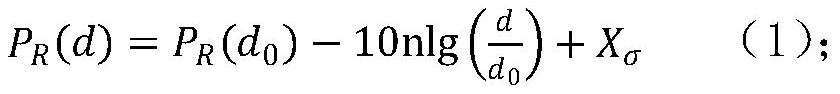
[0050] Step 1: In the forest environment where the fire monitoring system is used, trees of various varieties and sizes and other facilities are densely distributed and unevenly distributed. RF signal modeling gets complicated. Since the monitoring node itself has communication capabilities, it can complete the measurement of RSSI while receiving wireless data, and the network does not need to add additional hardware; therefore, in the forest environment of fire monitoring with limited power consumption and cost, it is more appropriate to use the logarithmic distance path loss model , set up the logarithmic distance path loss model according to formula (1), to obtain the RSSI value expression;

[0051]

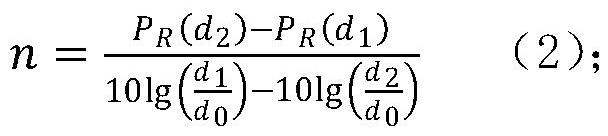
[0052] In the formula, n is the path loss ind...


PUM


Abstract

The invention discloses a fire monitoring network positioning method based on RSSI distance measurement. The method comprises the following steps: establishing a logarithmic distance path loss model; according to the position of a known reference node, periodically and dynamically measuring to obtain the received signal strength between the known reference node and a neighbor reference node, and obtaining a path loss index n value in a monitoring area at the current moment by using a logarithmic distance path loss model; calculating distances between a reference node and other reference nodes in the network by measuring a PR (d) value by using an RF signal propagation attenuation model, comparing the measured distance with an actual distance, and obtaining a measurement error of the PR (d) value at the reference node; and estimating the coordinates of the monitoring nodes by using a forgetting adjustment factor-based RLS positioning algorithm. According to the method, the influence of factors such as RSSI ranging errors and the number of reference nodes on the positioning precision can be fully considered, the positioning effect is ideal, and the positioning requirements of a fire environment monitoring system with a complex and severe network environment and limited positioning cost can be met.

Description

technical field [0001] The invention belongs to the technical field of fire monitoring, and in particular relates to a fire monitoring network positioning method based on RSSI ranging. Background technique [0002] Wireless sensor network (WSN) can perceive, collect, transmit and process environmental data in the monitoring area through sensors and wireless communication in real time, and can also implement low-power unmanned continuous monitoring in areas with harsh environments that humans cannot reach. Monitor jobs. Node coordinate position information is not only the basis for applications such as target monitoring and tracking, but also can improve routing efficiency and implement self-configuration of wireless network topology. The wireless network fire monitoring system can minimize the damage to buildings. The self-organization of the wireless network enables the disaster monitoring system to be networked in a short time, and it can realize the monitoring of dangero...

Claims


Application Information

Patent Timeline
Patent Type & Authority Applications(China)
IPC IPC(8): H04W4/02H04W84/18
CPCH04W4/023H04W4/025H04W84/18
Inventor 张新荣常波
Owner HUAIYIN INSTITUTE OF TECHNOLOGY
Why Eureka
Try Eureka