Point cloud classification method for LiDAR full waveform control decomposition driving

A waveform decomposition and full waveform technology, applied in radio wave measurement systems, instruments, etc., can solve the problems of small number of echo samples, limited accuracy of ground object classification, waveform distortion, etc., and achieve accurate waveform decomposition and extraction, accurate and efficient classification. Effect

Pending Publication Date: 2021-10-08
扆亮海
View PDF0 Cites 1 Cited by
  • Summary
  • Abstract
  • Description
  • Claims
  • Application Information

AI Technical Summary

Problems solved by technology

[0010] First, traditional discrete airborne LiDAR systems only record the first and last echoes reflected by ground objects, while multi-echo systems record up to 4 or 5 echoes. Both systems can only provide users with The three-dimensional point coordinates and related intensity information are used for the classification of ground objects, three-dimensional reconstruction of cities, and forest evaluation for geometric information. Only the geometric information of point clouds is used, or at most intensity information is added. Limitations; processing full waveform data can not only extract parameters that reflect the vertical structure and physical characteristics of ground objects, but also generate 3D point clouds with higher density and higher precision, which is comparable to the discrete point cloud data acquired by multi-echo airborne LiDAR Compared with the waveform data of full-waveform airborne LiDAR, it can provide more target information, but it also puts forward higher requirements for the analysis and information extraction of full-waveform data, but the existing technology cannot quickly and accurately extract the waveform decomposition Parameters, accurate point cloud results cannot be obtained in subsequent processing;
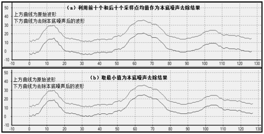
[0011] Second, for the removal of the background noise of the LiDAR waveform data, the existing technology mainly regards the ten sampling points before and after the waveform as data without ground echo information, and removes the mean value as the background noise. This method performs large-spot LiDAR The removal of the background noise is feasible, but the flight altitude of the small-spot airborne LiDAR is low, and the number of echo samples is small. The first ten and last ten sampling clocks may contain ground echo signals. If this mean value is directly used as the background noise, Will produce errors that affect subsequent processing
When the number of complex echoes on the ground is large, the part exceeding the system sampling number will not be recorded, and the sampling points at the end of waveform digitization contain ground echo information; when there are tall ground objects, the sampling points at the beginning of waveform digitization also contain For the echo data of ground objects, if the mean value of these points is simply removed from the original waveform as the background noise, the removed background noise will be greater than the actual value, and some weaker ground echoes will be mistaken for noise, resulting in The waveform after denoising does not match the actual one, which affects the final decomposition result, and then affects the calculation and classification results of the point cloud coordinates. The existing technology lacks a method to remove the background noise of LiDAR full waveform;
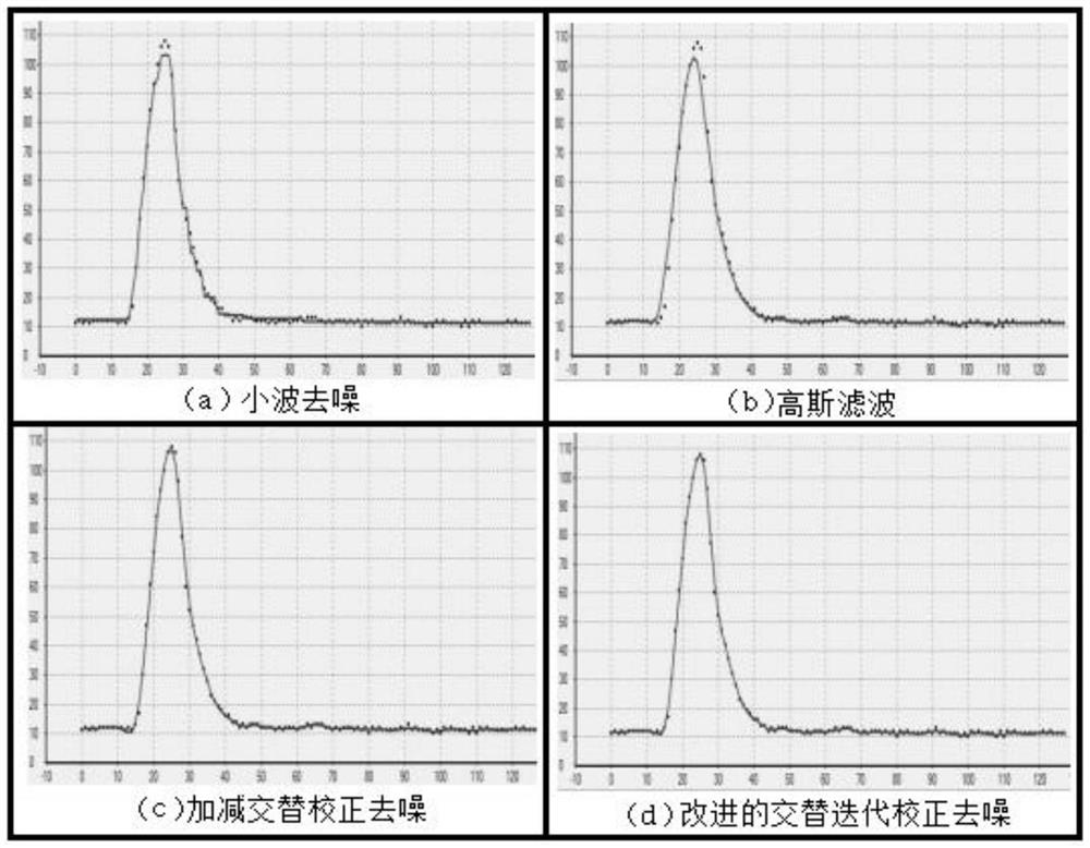
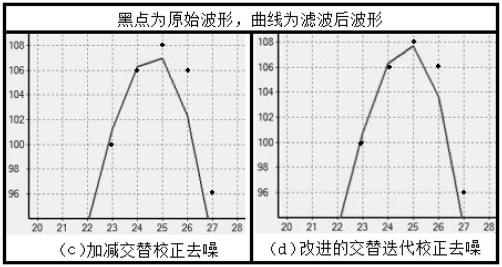
[0012] Third, the noise distribution in the LiDAR signal is very complex. It is unrealistic to denoise the signal only by selecting a cut-off frequency with a traditional digital filter. Seriously, wavelet multi-scale decomposition and reconstruction requires a large amount of calculation. If it is used for denoising thousands of LiDAR echoes, it will consume too much time and space. As for denoising in the spatial domain, if you want to obtain a better denoising effect, The prior knowledge of the LiDAR signal should be added to the training of the support vector machine. The LiDAR waveform is not a superposition of Gaussian distribution, and the denoising result is not ideal. The traditional image space domain processing and filtering algorithm does not need the prior knowledge of the waveform, but these algorithms are in While denoising, the waveform will be distorted. The existing technology lacks a method to remove the random noise of the LiDAR full waveform;
[0013] Fourth, after estimating the number of sub-waveforms and their initial values ​​of waveform eigenfactors, it is necessary to optimize the initial value of the estimated eigenfactors so that the Gaussian wave fitted by the sub-waveforms is closest to the original waveform data, and the airborne LiDAR full-waveform data The waveform decomposition problem is a multi-dimensional nonlinear optimization problem. The algorithms commonly used to solve such problems include gradient method, quasi-Newton method, LM algorithm, and EM algorithm. The LM algorithm overcomes the Gauss-Newton algorithm and the search fails when the Jacobian matrix is ​​a non-column matrix. problem, but the LM algorithm is easy to obtain the local optimal solution; the evolutionary method uses multi-point parallel search, generates new individuals through crossover and mutation in each iteration process, and continuously expands the search range, so the evolutionary algorithm is easy to search for the global optimal solution Instead of a local optimal solution; the prior art lacks a method for optimizing the eigenfactors for LiDAR full waveform decomposition

Method used


Image

  • Point cloud classification method for LiDAR full waveform control decomposition driving
  • Point cloud classification method for LiDAR full waveform control decomposition driving
  • Point cloud classification method for LiDAR full waveform control decomposition driving

Examples


Embodiment Construction

[0098] The following is a further description of the technical solution of the LiDAR full-waveform control decomposition-driven point cloud classification method provided by the application in conjunction with the accompanying drawings, so that those skilled in the art can better understand the application and implement it.

[0099] Traditional discrete airborne LiDAR usually only records the first echo and the last echo reflected by ground objects, while the multi-echo system records up to 4 to 5 echoes. Both systems can only provide users with three-dimensional point coordinates and related strength information. The airborne small-spot full-waveform LiDAR system can record the entire backscattered echo waveform of the scatterer at a small sampling interval, and the user can extract more information through independent processing and analysis of the full waveform data.

[0100] Based on the Gaussian properties of the airborne LiDAR full-waveform data, this application decompose...


PUM


Abstract

The invention relates to a point cloud classification method for LiDAR full waveform control decomposition driving. According to the point cloud classification method, wavelet factors are estimated from original waveforms one by one by adopting a layer-by-layer extraction method, the estimated waveform characteristic factors are optimized by adopting a dynamic global algorithm, the characteristic factors obtained by waveform decomposition are extracted, and high-density point cloud is generated, and finally, the point cloud data is classified by adopting an SVM based on the waveform characteristic factors. According to LiDAR full-waveform data preprocessing, an algorithm suitable for removing LiDAR full-waveform random noise is put forward, and an addition and subtraction alternate iteration correction denoising method is improved, so that a processing result is better. According to LiDAR full-waveform data decomposition, the dynamic global algorithm is introduced in characteristic factor optimization, and control is added in the optimization process, so that an optimization result does not deviate from reality. The point cloud classification based on the waveform characteristic factors is performed. Rapid and accurate waveform decomposition extraction of the airborne small-spot full-waveform LiDAR is realized, and accurate and efficient classification of the point clouds of the LiDAR is realized.

Description

technical field [0001] The present application relates to a LiDAR full-waveform point cloud classification method, in particular to a LiDAR full-waveform control decomposition-driven point cloud classification method, which belongs to the technical field of LiDAR point cloud classification. Background technique [0002] Airborne LiDAR is a remote sensing data acquisition technology that has developed rapidly in recent years. It can quickly and directly acquire spatial three-dimensional coordinates. With its high precision, high efficiency, and low cost, it is widely used in terrain surveying, urban modeling, and power line extraction. and other fields. [0003] Traditional discrete airborne LiDAR systems only record the first and last echoes reflected by ground objects, while multi-echo systems record up to 4 to 5 echoes. Both systems can only provide users with three-dimensional point coordinates And relevant intensity information, users can use 3D coordinates and intensit...

Claims


Application Information

Patent Timeline
IPC IPC(8): G01S7/48
CPCG01S7/4802
Inventor 扆亮海
Owner 扆亮海
Why Eureka
Try Eureka