River island form quantitative characterization method

A quantitative characterization and morphology technology, applied in geophysical surveying, special data processing applications, instruments, etc., can solve problems such as high data requirements and complex quantitative analysis and description of reservoir mid-shoals

Pending Publication Date: 2021-10-29
CHINA PETROLEUM & CHEM CORP +1
View PDF1 Cites 0 Cited by
  • Summary
  • Abstract
  • Description
  • Claims
  • Application Information

AI Technical Summary

Problems solved by technology

[0006] The purpose of the present invention is to provide a quantitative characterization method for mid-shoal morphology to solve the prob

Method used


Image

  • River island form quantitative characterization method
  • River island form quantitative characterization method
  • River island form quantitative characterization method

Examples


Embodiment 1

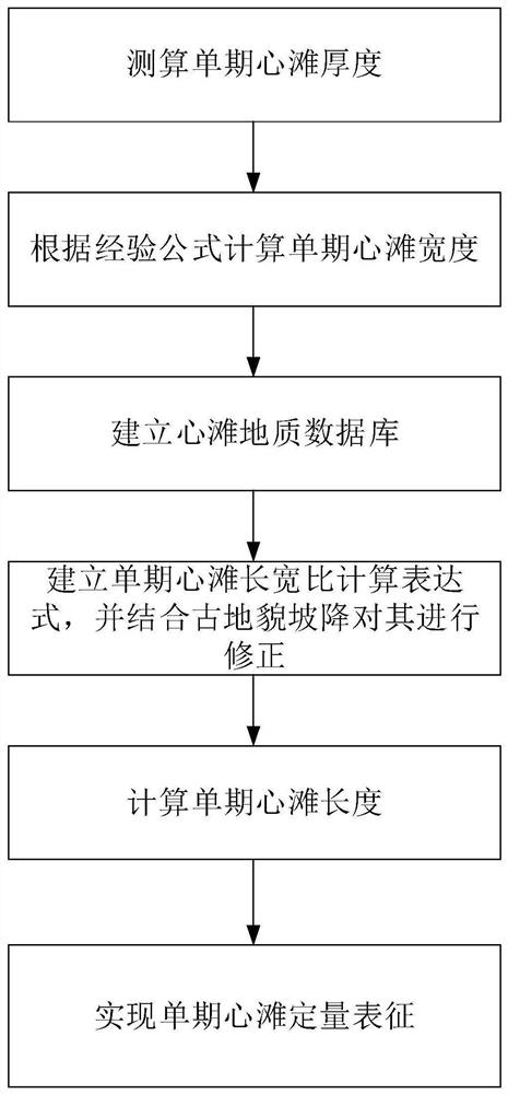
[0031] Taking a fluvial facies reservoir development area A in the northern margin of a certain basin as an example, the quantitative characterization method for channel shoal morphology provided by the present invention is introduced in detail, figure 1 It is a flow chart of the quantitative characterization method of the shoal morphology of the present invention, specifically, including the following steps:

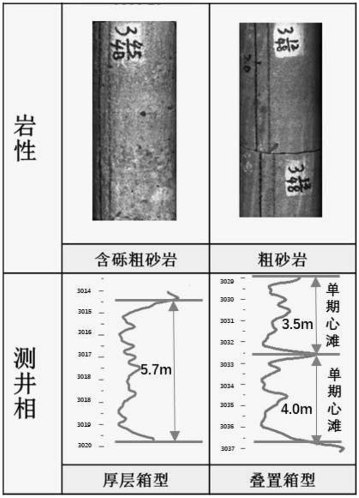
[0032] (1) According to the actual drilled core data of 20 coring single wells in the target area, the single-period mid-shoal is identified and the thickness of the single-stage mid-shoal is measured; Table 1 shows the statistics of the single-stage mid-shoal thickness.

[0033] Table 1

[0034]

[0035]

[0036] In this example, the sandstone particle size value in the known coring data is used. When the sandstone particle size value is <2mm, and the pebble-coarse sandstone or coarse sandstone is oriented, it is judged as a core bank. Combined with the core data...

Embodiment 2

[0059] The difference between the quantitative characterization method of the mid-shoal proposed in this example and the first embodiment of the quantitative characterization method of the mid-shoal lies in the different means of measuring the thickness of the mid-shoal. This embodiment uses the combination of well logging data, such as figure 2 As shown, the single-period cardiac beach thickness was measured.

[0060] The single-period mid-shoal thickness in this embodiment is obtained through the well logging curve in the known logging data, that is, GR<55API in the natural gamma ray curve in the logging data, when the logging curve presents a box-shaped feature, then It is judged as the central beach, which is obtained by directly reading the single-phase central beach thickness at the central beach position.

[0061] The other implementation steps of the quantitative characterization method for the midshore are basically the same as in the first embodiment of the quantita...

Embodiment 3

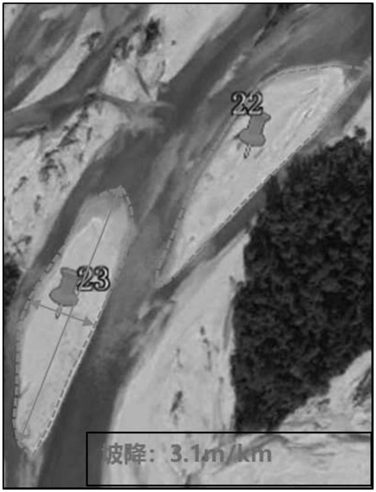
[0063] The difference between the channel shoal quantitative characterization method proposed in this example and the first embodiment of the channel shoal quantitative characterization method is that the means of geological statistics are different, that is, the geological statistics of modern rivers in typical braided river depositional areas are carried out by ArcGIS software , to establish a quantitative midshore geological database.

[0064] Wherein, in this embodiment, the river network in the braided river deposition area is directly extracted and analyzed through ArcGIS software, and the specific means are existing technologies, which will not be described in this embodiment.

[0065] The other implementation steps of the quantitative characterization method for the midshore are basically the same as in the first embodiment of the quantitative characterization method for the midshore, which have been introduced in the first embodiment of the quantitative characterizatio...


PUM

PropertyMeasurementUnit
Widthaaaaaaaaaa
Thicknessaaaaaaaaaa

Abstract

The invention relates to a river island form quantitative characterization method, which mainly comprises the following steps of: firstly, obtaining a single-period river island thickness according to known data, and calculating a single-period river island width; carrying out geology statistics on the braided river sedimentary land of the target area, establishing a core beach geological database, fitting a calculation expression of a single-period river island length-width ratio, selecting actual drilling sand bodies of the drilled horizontal well for dissection, and correcting the sand bodies in combination with the paleo-geographical slope of the paleo-landform of the target area; determining the actual length-width ratio of the single-period river island of the target area; and finally, calculating the length of the single-period river island by combining the actual length-width ratio of the single-period river island and the width of the single-period river island, and realizing quantitative characterization of the single-period river island. The method provided by the invention has low requirements on required data information and is simple.

Description

technical field [0001] The invention relates to a quantitative characterization method for mid-shoal morphology, which belongs to the field of oil and gas field development geology in the petroleum industry. Background technique [0002] Fluvial sedimentary reservoir is the main type of reservoir, and its oil and gas reserves have accounted for about 65% of the produced reserves of my country's oil and gas fields. With the continuous development of such oil and gas fields, oil and gas resources and reserves are decreasing, and the distribution of remaining oil and gas is more scattered and complex. , It is becoming more and more difficult to tap the potential. [0003] In the actual development of oil and gas fields dominated by braided river deposits, the problems of strong heterogeneity and unsatisfactory single well implementation effects have emerged. The traditional sedimentary microfacies research model can no longer meet the needs of fine development of oil and gas fi...

Claims


Application Information

Patent Timeline
IPC IPC(8): G06F30/20G06F16/29G01V9/00
CPCG06F30/20G06F16/29G01V9/00
Inventor 王国壮曹桐生苏程张占杨杨帆
Owner CHINA PETROLEUM & CHEM CORP
Why Eureka
Try Eureka