A Tree Crown Extraction Method Based on UAV Multi-source Remote Sensing

An extraction method and unmanned aerial vehicle technology, applied in the field of remote sensing recognition, can solve the problems of low recognition accuracy and insufficient spatial information for tree species recognition in remote sensing images, and achieve the effect of increasing accuracy

Active Publication Date: 2022-06-03
RES INST OF FOREST RESOURCE INFORMATION TECHN CHINESE ACADEMY OF FORESTRY
View PDF9 Cites 0 Cited by
  • Summary
  • Abstract
  • Description
  • Claims
  • Application Information

AI Technical Summary

Problems solved by technology

[0006] The present invention provides a tree crown extraction method based on UAV multi-source remote sensing, which is suitable for dense forest tree crown identification, aiming at the problem of insufficient spatial information and low recognition accuracy of remote sensing image tree species identification

Method used


Image

  • A Tree Crown Extraction Method Based on UAV Multi-source Remote Sensing
  • A Tree Crown Extraction Method Based on UAV Multi-source Remote Sensing
  • A Tree Crown Extraction Method Based on UAV Multi-source Remote Sensing

Examples


Embodiment Construction

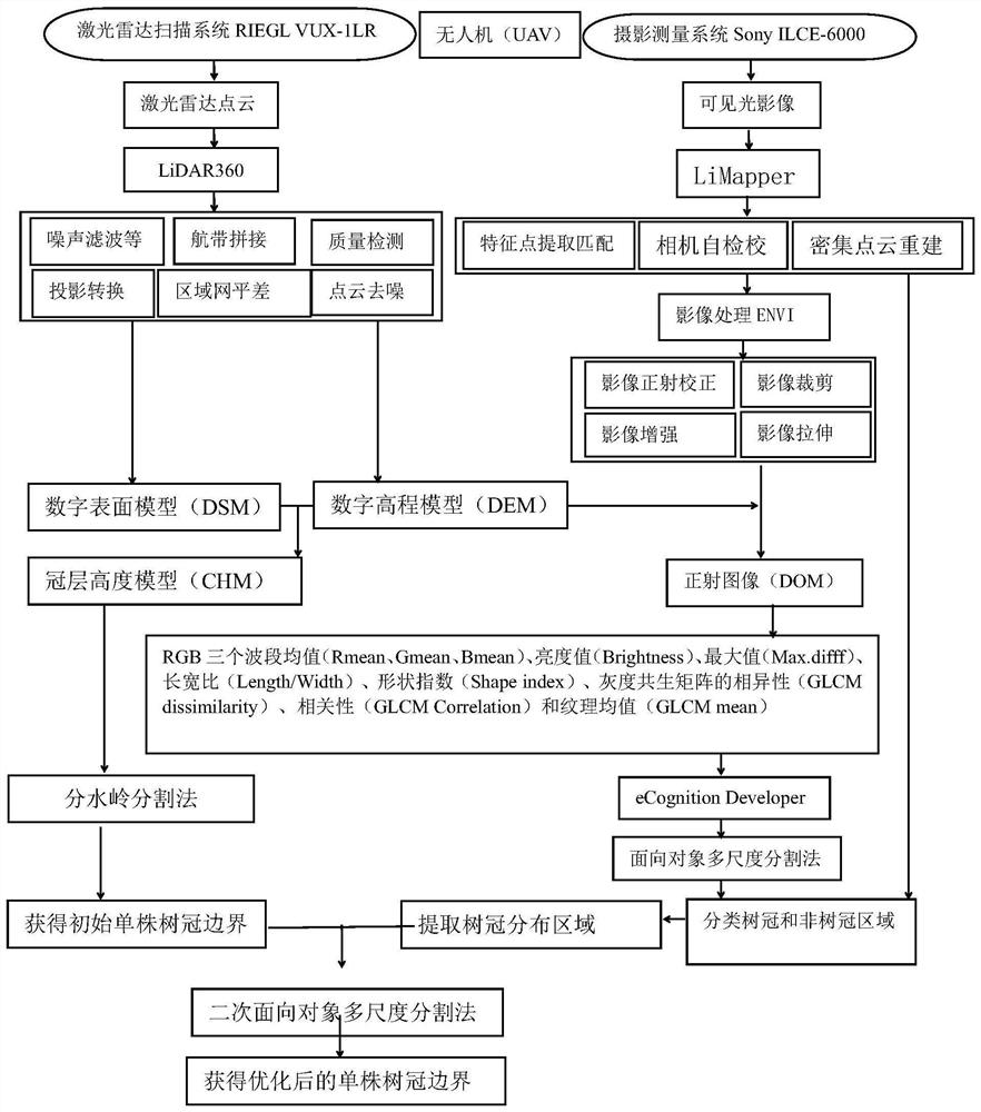
[0044] The principles and features of the present invention are described below, and the examples are only used to explain the present invention, but not to limit the scope of the present invention.

[0045] like figure 1 As shown, the following steps are included in this embodiment:

[0046] A Obtain visible light image and lidar point cloud, preprocess the lidar point cloud to obtain the preprocessed lidar point cloud, and preprocess the visible light image to obtain the orthophoto image;

[0047] The drone data is acquired by a digital smectite fixed-wing drone with a body length of 60cm×60cm×50cm, a take-off weight of 16.5kg, and a maximum load of 8kg. The sensors include two types of high spatial resolution visible light cameras and lidar scanners. Type, the data collection time was July 2019, the weather was clear and no wind, the flight speed was 6m / s, the flight altitude was 160m, and the average heading overlap rate was 83.21%. The visible light sensor is Sony ILCE-...


PUM


Abstract

The invention discloses a tree crown extraction method based on multi-source remote sensing of UAV, which includes obtaining visible light image and laser radar point cloud, taking the visible light orthophoto image of UAV and laser radar point cloud as data sources, adopting watershed segmentation and oriented The method of combining object multi-scale segmentation to extract single tree canopy information under different canopy density. First, the object-oriented multi-scale segmentation method is used to extract the canopy and non-canopy areas of UAV visible light images, and the canopy distribution range is extracted using the canopy area as a mask; Based on the CHM constructed by UAV lidar, the watershed segmentation method is used to obtain the preliminary segmentation results of the single tree canopy; based on the canopy boundary of the watershed segmentation, and the brightness value of the visible light orthophoto image is characterized, the canopy area of ​​the visible light orthophoto image is binary. Subdivided to obtain the optimized single tree canopy boundary information, which greatly increases the accuracy of remote sensing canopy extraction.

Description

technical field [0001] The invention belongs to the technical field of remote sensing identification, and in particular relates to a tree crown extraction method based on multi-source remote sensing of unmanned aerial vehicles. Background technique [0002] Tree canopy is an important parameter of forest survey. The traditional method of obtaining tree crown parameters is mainly by artificial ground survey. This method is time-consuming, labor-intensive, and labor-intensive, and is not conducive to large-scale forest surveys. The birth of high spatial resolution remote sensing provides an important means for the rapid extraction of large-scale tree crowns. It has the incomparable advantages of traditional survey methods. High-resolution satellite remote sensing for tree canopy extraction still has the shortcomings of low spatial resolution and poor flexibility. [0003] In recent years, high-resolution aerial remote sensing, especially the rapid development of UAV remote s...

Claims


Application Information

Patent Timeline
Patent Type & Authority Patents(China)
IPC IPC(8): G06T7/11G06T7/12G06V20/17G06V10/764
CPCG06T7/11G06T7/12G06T2207/10044G06T2207/10028G06T2207/30188G06T2207/10032G06F18/24G06V20/17G06V20/188G06V10/764G06T7/187G06T2207/10024G06T7/13G06T7/149G06T7/155G06V10/443
Inventor 陈巧陈永富王娟徐志扬
Owner RES INST OF FOREST RESOURCE INFORMATION TECHN CHINESE ACADEMY OF FORESTRY
Why Eureka
Try Eureka