Method for avoiding optical remote sensing satellite image water flare and electronic equipment

A satellite image and optical remote sensing technology, applied in the field of remote sensing satellite images, can solve the problem that the quality of remote sensing satellite images does not meet the actual needs, and achieve the effect of avoiding water flares

Active Publication Date: 2021-12-17
CHINA CENT FOR RESOURCES SATELLITE DATA & APPL
View PDF3 Cites 1 Cited by
  • Summary
  • Abstract
  • Description
  • Claims
  • Application Information

AI Technical Summary

Problems solved by technology

[0005] The technical problem solved by this application is: aiming at the quality of remote sensing satellite images collected in the prior art does not meet the actual needs, this application provides a method and electronic equipment for avoiding water body flares in optical remote sensing satellite images. In the scheme provided, the avoidance of

Method used


Image

  • Method for avoiding optical remote sensing satellite image water flare and electronic equipment
  • Method for avoiding optical remote sensing satellite image water flare and electronic equipment
  • Method for avoiding optical remote sensing satellite image water flare and electronic equipment

Examples


Embodiment Construction

[0045] In the solutions provided by the embodiments of the present application, the described embodiments are only some of the embodiments of the present application, not all of the embodiments. Based on the embodiments in this application, all other embodiments obtained by persons of ordinary skill in the art without making creative efforts belong to the scope of protection of this application.

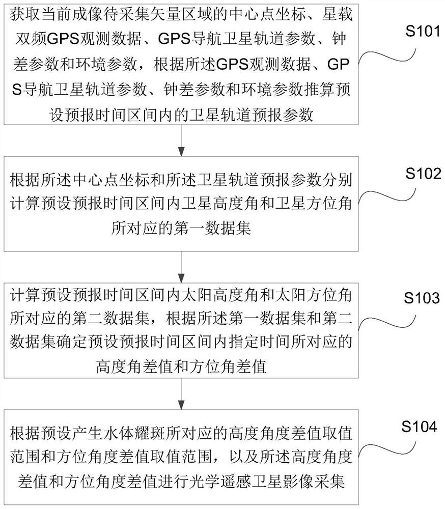
[0046] A method for avoiding water body flares in optical remote sensing satellite images provided by the embodiments of the present application will be described in further detail below in conjunction with the accompanying drawings. The specific implementation of the method may include the following steps (the method flow is as follows: figure 1 shown):

[0047] Step 101, obtain the coordinates of the center point of the current imaging vector area to be collected, satellite-borne dual-frequency GPS observation data, GPS navigation satellite orbit parameters, clock error parameters ...


PUM


Abstract

The invention discloses a method for avoiding optical remote sensing satellite image water flareand electronic equipment. The method comprises the steps of obtaining the center point coordinate, satellite-borne dual-frequency GPS observation data, GPS navigation satellite orbit parameters, clock error parameters and environment parameters of a current imaging to-be-collected vector region, calculating satellite orbit forecasting parameters in a preset forecasting time interval, respectively calculating first data sets corresponding to a satellite elevation angle and a satellite azimuth angle according to the center point coordinates and the satellite orbit forecasting parameters, calculating a second data set corresponding to the solar elevation angle and the solar azimuth angle, and determining an elevation angle difference value and an azimuth angle difference value corresponding to specified time according to the first data set and the second data set, and performing optical remote sensing satellite image acquisition according to a preset height angle difference value range and an azimuth angle difference value range. The technical problem that in the prior art, the quality of a water body area of a collected remote sensing satellite image does not meet actual requirements is solved.

Description

technical field [0001] The present application relates to the technical field of remote sensing satellite images, in particular to a method and electronic equipment for avoiding water body flares in optical remote sensing satellite images. Background technique [0002] Gaojing-1 remote sensing satellite constellation plays an important role in military defense, resource exploration, environmental monitoring and other fields by virtue of its advantages of strong mobility, diverse collection modes, and short revisit cycle. It is the core of the commercial remote sensing satellite market such as Gaojing-1, and water application is an important application field. Since optical remote sensing satellites use their camera loads to collect solar reflection radiation energy from the surface of the observation target to achieve remote sensing purposes, when the satellite images a water body area, especially a calm water surface, if the satellite observation vector and the sun incident...

Claims


Application Information

Patent Timeline
IPC IPC(8): G01S19/40
CPCG01S19/40
Inventor 赫华颖刘啸添郭正齐齐文雯齐怀川郭明珠乔敏田甜
Owner CHINA CENT FOR RESOURCES SATELLITE DATA & APPL
Why Eureka
Try Eureka