
Satellite sensor radiation time sequence calibration method based on accurate sun-earth distance

A sensor and satellite technology, applied in the field of quantitative remote sensing, can solve problems such as long-term sequence consistency analysis of unfavorable satellite remote sensing data, and achieve the effects of improving stability, accuracy and consistency.

Active Publication Date: 2021-12-31
LUDONG UNIVERSITY
View PDF3 Cites 0 Cited by
  • Summary
  • Abstract
  • Description
  • Claims
  • Application Information

AI Technical Summary

Problems solved by technology

These methods give the calibration coefficients of each channel in different time periods. Usually, the radiation calibration coefficients of satellite sensors are stable within a certain period of time, which leads to the jumping of the radiation calibration coefficients of satellite sensors in different time periods. Changes, not conducive to long-term series consistency analysis of satellite remote sensing data

Method used


Image

  • Satellite sensor radiation time sequence calibration method based on accurate sun-earth distance
  • Satellite sensor radiation time sequence calibration method based on accurate sun-earth distance
  • Satellite sensor radiation time sequence calibration method based on accurate sun-earth distance

Examples


Embodiment Construction

[0052] In order to make the purpose, technical solution and advantages of the present application clearer, the technical solution of the present application will be clearly and completely described below in conjunction with specific embodiments of the present application and corresponding drawings. Apparently, the described embodiments are only some of the embodiments of the present application, rather than all the embodiments. Based on the embodiments in this application, all other embodiments obtained by persons of ordinary skill in the art without making creative efforts belong to the scope of protection of this application.

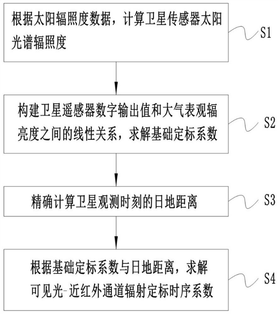
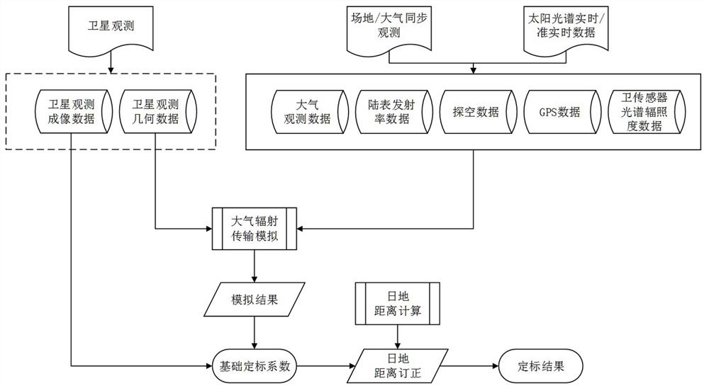
[0053] Such as Figure 1-2 As shown, a radiation timing calibration method for satellite sensors based on the precise sun-earth distance includes:

[0054] S1. Calculate the solar spectral irradiance of the satellite sensor according to the real-time solar irradiance data. The solar irradiance data is real-time or quasi-real-time solar irradiance da...


PUM


Abstract

The invention discloses a satellite sensor radiation time sequence calibration method based on an accurate sun-earth distance, and belongs to the technical field of quantitative remote sensing. The method comprises the following steps: constructing a linear relation between a satellite sensor digital output value and atmospheric apparent radiance, and solving a basic calibration coefficient; accurately calculating the sun-earth distance at the satellite observation moment; and solving a visible light-near infrared channel radiometric calibration time sequence coefficient according to the basic calibration coefficient and the sun-earth distance. The consistency of the data set suitable for space-time big data analysis can be effectively improved, the stability of satellite sensor radiometric calibration is improved, and the radiometric calibration precision is improved.

Description

technical field [0001] The invention relates to the technical field of quantitative remote sensing, in particular to a method for calibrating radiation time series of satellite sensors based on precise sun-earth distance. Background technique [0002] Remote sensing is a technology and science that uses the detector to record the electromagnetic wave characteristics of the target without contacting the detection target, and obtain relevant information such as object characteristics through analysis. The data observed by remote sensing satellites need to be converted into geometric or physical quantities before they can be used scientifically. The process of remote sensing data conversion is calibration. Generally speaking, remote sensing satellite calibration techniques are divided into two categories: geometric calibration and radiometric calibration. Among them, geometric calibration is the key technology to achieve high-precision positioning of satellite remote sensing i...

Claims


Application Information

Patent Timeline
IPC IPC(8): G01J3/28
CPCG01J3/2823G01J2003/2866
Inventor 孔祥生钱永刚王秋萍韩宗涛张雅洲
Owner LUDONG UNIVERSITY
Learn More