MR navigation method based on point cloud map visual localization

A technology of visual positioning and navigation method, applied in directions such as navigation, mapping and navigation, navigation calculation tools, etc., to achieve the effect of enhancing somatosensory and overcoming signal strength

Pending Publication Date: 2022-01-07
南京惊涛智能科技有限公司
View PDF0 Cites 1 Cited by
  • Summary
  • Abstract
  • Description
  • Claims
  • Application Information

AI Technical Summary

Problems solved by technology

[0006] In view of the above-mentioned deficiencies in the prior art, the purpose of the present invention is to propose a MR navigation method based on point cloud map visual positioning to solve the problem of improving navigation accuracy and flexibility in a closed local complex environment

Method used


Image

  • MR navigation method based on point cloud map visual localization

Examples


Embodiment Construction

[0017] The specific implementation of the present invention will be further described in detail below, so as to make the technical solution of the present invention easier to understand and grasp, so as to define the protection scope of the present invention more clearly.

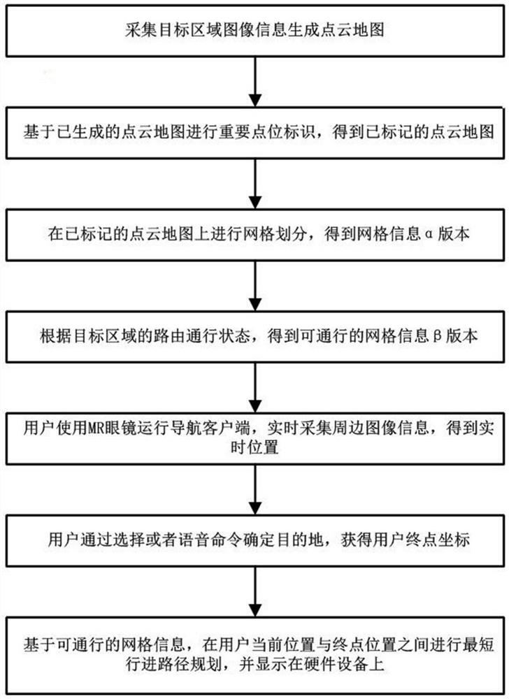
[0018] In view of the fact that the existing navigation system is mainly responsible for positioning and navigation in a wide area, and the local area or indoor complex environment navigation is subject to the problem of signal strength and poor positioning accuracy. Technology research experience, innovatively proposed a MR navigation method based on point cloud map visual positioning, using and expanding the functions of MR equipment, and proposed a new technical solution for detailed navigation and positioning of large shopping malls, indoor museums and other places.

[0019] From an overview of the MR navigation method of the present invention, it first obtains a point cloud map that is 1:1 restored to t...


PUM


Abstract

An MR navigation method based on point cloud map visual localization is disclosed and applied in the invention. The current position of a user is obtained in real time through visual localization, and a navigation service for path planning is provided. The method comprises the following steps: acquiring a point cloud map which is restored according to a ratio of 1: 1 with a target area through data acquisition and calculation processing, acquiring peripheral image information of a user in real time through a depth camera of MR equipment, and performing feature point matching operation with the point cloud map of the target area to obtain current positioning data of the user; and enabling a navigation application integrated by the MR equipment to perform real-time path planning according to the positioning data and the final position calibrated by the user. By applying the MR navigation method disclosed by the invention, the blank of navigation of navigation systems such as a GPS and the like on a local indoor environment is filled, personnel positioning and visual navigation presentation are realized by collecting and matching on-site feature points obtained from local materials, and the problems that an existing navigation scheme is limited by signal strength, navigation fails and the like are solved; and the navigation effect is visually displayed through the MR equipment, so that the somatosensory is enhanced.

Description

technical field [0001] The invention relates to a digital image navigation method, in particular to an MR navigation method based on point cloud map visual positioning, which is suitable for non-wide-area local space. Background technique [0002] With the development of science and technology, digital navigation technology solutions have been widely used in the direction guidance of various types of aircraft, ships, vehicles and other vehicles, whether it is manual driving or fully automatic driving. Among them, the application of small motor vehicle navigation, which is the most popular, is the most popular. For wide-area route navigation, products from multiple map software companies can be used for route planning and navigation, allowing drivers to quickly find suitable roads between cities or in different cities to reach their destinations, improving and greatly improving the efficiency of people's travel . [0003] However, in people's actual activities, the concept ...

Claims


Application Information

Patent Timeline
Patent Type & Authority Applications(China)
IPC IPC(8): G01C21/20
CPCG01C21/206
Inventor 于云沣周晖纪芸芸
Owner 南京惊涛智能科技有限公司
Why Eureka
Try Eureka