Real-time positioning method and device fusing laser radar and IMU sensor information

A laser radar, real-time positioning technology, applied in the direction of measuring devices, instruments, electromagnetic wave re-radiation, etc., can solve the problems that the NDT positioning results cannot be directly used in the control link, the positioning is delayed, and the NDT positioning frequency is low. Real-time and robustness, suppressing delay, reducing the effect of time delay

Pending Publication Date: 2022-01-21
BEIJING INSTITUTE OF TECHNOLOGYGY
View PDF0 Cites 5 Cited by
  • Summary
  • Abstract
  • Description
  • Claims
  • Application Information

AI Technical Summary

Problems solved by technology

[0004] In order to solve the above-mentioned technical problems, the present invention proposes a real-time positioning method and device that fuses laser radar and IMU sensor information. Due to low-speed motion, NDT positioning results cannot be directly used for technical problems in the control link

Method used


Image

  • Real-time positioning method and device fusing laser radar and IMU sensor information
  • Real-time positioning method and device fusing laser radar and IMU sensor information
  • Real-time positioning method and device fusing laser radar and IMU sensor information

Examples


Embodiment Construction

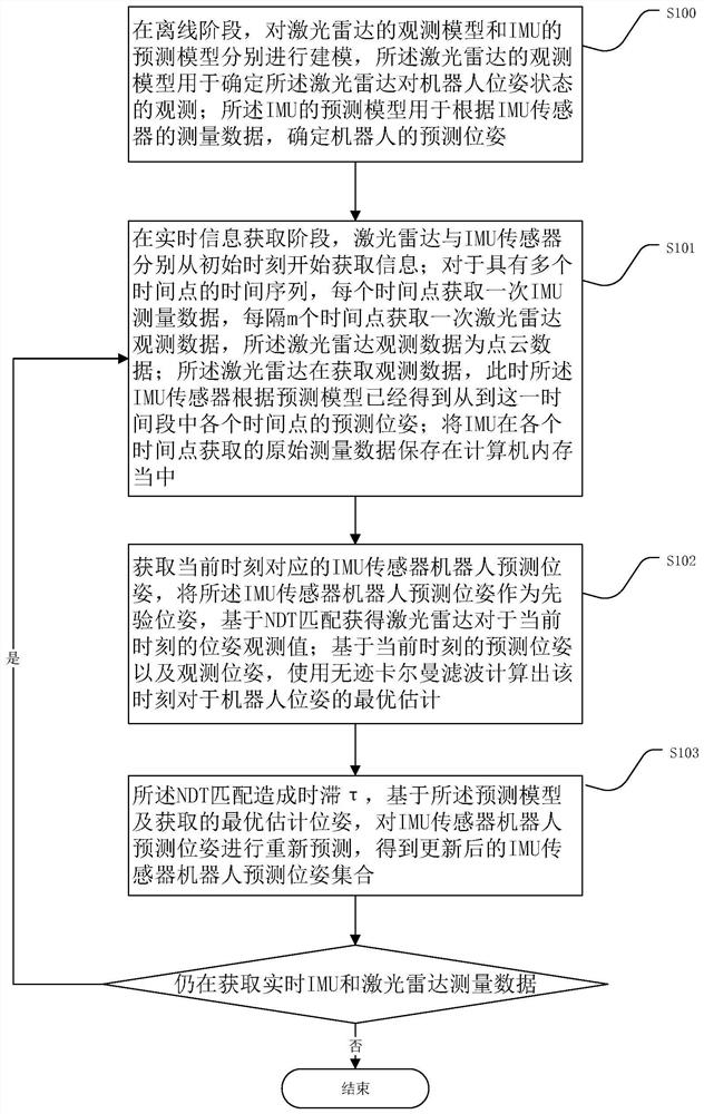
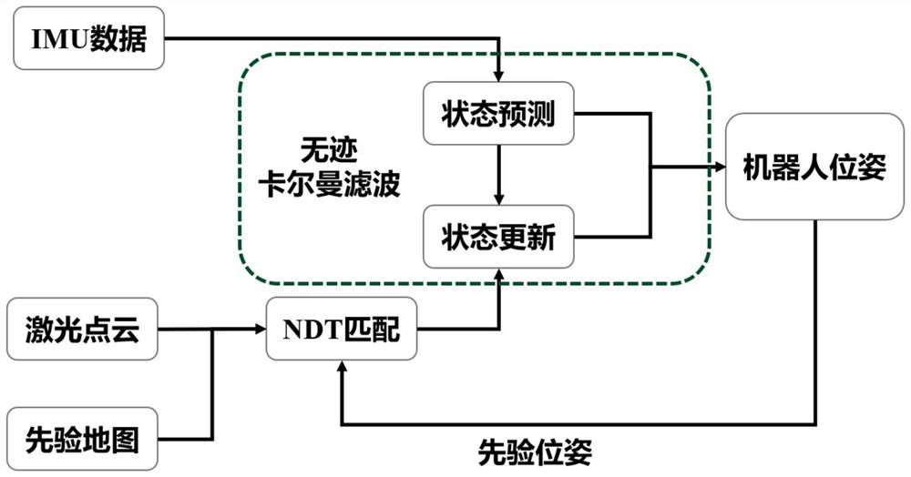
[0030] combine first Figure 1-3 Illustrate the flow of a real-time method for fusing lidar and IMU sensor information in an embodiment of the present invention, the method includes the following steps:

[0031] Step S100: In the offline stage, model the observation model of the lidar and the prediction model of the IMU respectively, and the observation model of the lidar is used to determine the impact of the lidar on the robot according to the point cloud matching result of the lidar. Observation of pose state; The predictive model of described IMU is used for determining the predictive pose of robot according to the measurement data of IMU sensor;

[0032] Step S101: In the real-time information acquisition stage, the lidar and IMU sensors acquire information from the initial moment respectively; for time series Time={t k-m ,t k-m+1 ...,t k}, IMU measurement data is obtained at each time point, and lidar observation data is obtained at every m time points, and the lidar ...


PUM


Abstract

The invention provides a real-time positioning method and device fusing laser radar and IMU sensor information, and the method comprises the steps: taking unscented Kalman filtering as a frame, carrying out the motion prediction of an unmanned platform through the data of a high-frequency inertial measurement unit, and caching the data; after the point cloud matching module receives the laser radar data with the timestamp, using the predicted pose as prior information, performing matching based on normal distribution transformation and a known point cloud map, and obtaining global positioning information with delay; using the positioning information for updating unscented Kalman filtering at the moment of the laser radar timestamp, calibrating the prediction error of the inertial measurement unit, and using the cached high-frequency inertial measurement unit data for performing re-prediction based on the positioning information, so that the low-delay and high-frequency positioning effect is realized. According to the method, high-frequency and low-delay real-time positioning can be realized, and a better control effect is brought.

Description

technical field [0001] The invention relates to the field of robot perception and navigation, in particular to a real-time positioning method and device for fusing laser radar and IMU sensor information. Background technique [0002] The positioning technology of the robot is the basic function for the robot to realize autonomous navigation and planning, which is of great significance to the mobile robot platform. Robot positioning technology is divided into positioning in a known environment or positioning in an unknown environment. The positioning problem of positioning in a known environment is also known as the relocation problem, that is, the robot determines in the case of a known environment map or measurement data. Find the position of the robot in the environment. Commonly used robot positioning technologies include satellite positioning, Wifi positioning, or positioning based on vision and laser sensors. Different from satellite positioning or Wifi positioning and...

Claims


Application Information

Patent Timeline
Patent Type & Authority Applications(China)
IPC IPC(8): G01S17/86G01S7/48
CPCG01S17/86G01S7/4802
Inventor 方浩班超窦丽华
Owner BEIJING INSTITUTE OF TECHNOLOGYGY
Why Eureka
Try Eureka