Method and system for extracting typical region in satellite remote sensing image

A satellite remote sensing and typical area technology, applied in the field of agricultural engineering, can solve the problems that the edge points cannot form an effective connected area, the processing of remote sensing images is inconvenient, and the automatic processing method cannot be effectively applied on a large scale, so as to improve the detection probability, The effect of reducing the error rate

Active Publication Date: 2022-02-11
北京中宇瑞德建筑设计有限公司
View PDF5 Cites 1 Cited by
  • Summary
  • Abstract
  • Description
  • Claims
  • Application Information

AI Technical Summary

Problems solved by technology

Under this method, all the edge points in the remote sensing image are generally extracted, including roads, residential areas, etc. It is difficult to directly obtain the outline of the target area, and even the edge points cannot form an effective connected area, and subsequent manual processing is still required. It is very inconvenient to deal with remote sensing image processing on a large scale
In addition, satellite remote sensing images are significantly affected by satellite orbits, seasons, light, ground lakes or the status of planted crops, and traditional automatic processing methods cannot be effectively applied to a wide range

Method used


Image

  • Method and system for extracting typical region in satellite remote sensing image
  • Method and system for extracting typical region in satellite remote sensing image
  • Method and system for extracting typical region in satellite remote sensing image

Examples


Embodiment 1

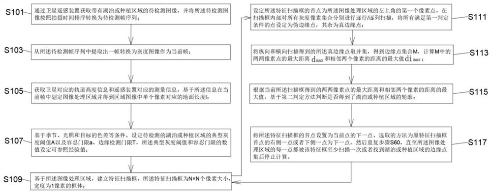
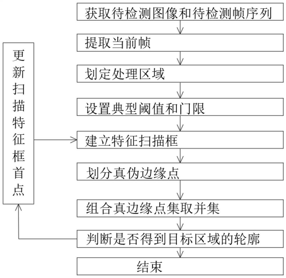
[0053] refer to Figure 1-2 , a method for extracting typical regions in satellite remote sensing images, comprising the following steps:

[0054] Step S101, acquiring images to be detected with lakes or planting areas through satellite remote sensing devices, and converting the images to be detected into frame sequences to be detected according to shooting time;

[0055] refer to image 3 , step S103, extracting a frame from the frame sequence to be detected and converting it into a grayscale image as the current frame;

[0056] Step S105, obtaining the orbital height information corresponding to the satellite and the measurement information corresponding to the remote sensing device, delineating the image processing area in the current frame based on the information and obtaining the ground length l corresponding to a single pixel in the area image;

[0057] Specifically, in step S105, based on the image processing area, the initial edge point set of the target lake or pla...

Embodiment 2

[0087] On the basis of Embodiment 1, including step S101-step S117:

[0088] Step S101, acquire images to be detected with lakes or planting areas through satellite remote sensing devices, and convert the images to be detected into a sequence of frames to be detected in order of shooting time. The frames to be detected can be common images such as PNG format and JPG format Format;

[0089] Step S103, extracting a frame from the frame sequence to be detected and converting it into a grayscale image as the current frame;

[0090] Step S105, based on the orbital height information corresponding to the satellite and the measurement information corresponding to the remote sensing device, define the image processing area as the entire image in the current grayscale frame, and obtain the ground length corresponding to a single pixel in the area image as 30m;

[0091] Step S107, based on conditions such as season, illumination and color difference of the target, set the gray threshol...


PUM


Abstract

The invention discloses a method and system for extracting a typical area in a satellite remote sensing image, and belongs to the field of agricultural engineering, and the method comprises the following steps: S101, obtaining a to-be-detected image with a lake or a planting area through a satellite remote sensing device, and converting the to-be-detected image into a to-be-detected frame sequence according to the shooting time sequence; S103, extracting a frame from the to-be-detected frame sequence, and converting the frame into a grayscale image as a current frame. The problems of long time consumption and low efficiency when similar satellite remote sensing images are manually processed on a large scale by using professional image processing software in traditional agricultural engineering are solved; the detection probability of a designated area is improved, the error rate is reduced, and the method can be better adapted to a computer to quickly process remote sensing image detection tasks on a large scale; and the method can be better adapted to the automatic contour detection task of different satellites, different remote sensing devices, different seasons, different lakes or planting areas.

Description

technical field [0001] The invention relates to the technical field of agricultural engineering, in particular to a method and system for extracting typical regions in satellite remote sensing images. Background technique [0002] In agricultural engineering, it is often necessary to process the contours of lakes or large or larger planting areas obtained based on satellite remote sensing images. The traditional contour extraction method is to obtain satellite remote sensing images, import images in PNG or JPG format into professional tools such as Photoshop, and obtain their edge points manually. The traditional method is suitable for small-batch satellite remote sensing image processing, which can obtain appropriate boundaries manually, and can add, delete or adjust edge points appropriately, but in large-scale remote sensing images, this method is time-consuming and laborious, and the efficiency is extremely low . In the method of automatically obtaining the outline of ...

Claims


Application Information

Patent Timeline
Patent Type & Authority Applications(China)
IPC IPC(8): G06V10/25G06V10/44G06V20/13
Inventor 张鹏宋玉良韩双江张大鹏唐一琳王娟
Owner 北京中宇瑞德建筑设计有限公司
Why Eureka
Try Eureka