Map construction method for accurate positioning based on multi-segment joint optimization

A technology for precise positioning and map construction, which is used in measurement devices, instruments, surveying and navigation, etc., and can solve the problems of complex feature extraction, affecting accuracy, and high cost of millimeter-wave radar.

Pending Publication Date: 2022-02-25
BEIJING UNIV OF TECH
View PDF0 Cites 5 Cited by
  • Summary
  • Abstract
  • Description
  • Claims
  • Application Information

AI Technical Summary

Problems solved by technology

However, the millimeter-wave radar used in this method is still more expensive than the camera sensor, and the noise-filled radar data makes feature extraction more complicated, thereby affecting accuracy

Method used


Image

  • Map construction method for accurate positioning based on multi-segment joint optimization
  • Map construction method for accurate positioning based on multi-segment joint optimization
  • Map construction method for accurate positioning based on multi-segment joint optimization

Examples


Embodiment Construction

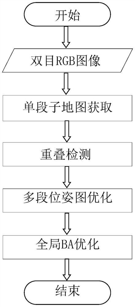
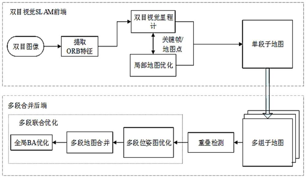
[0035] The purpose of the present invention is to provide a map construction method for precise positioning based on multi-segment joint optimization. First, a single-segment sub-map is obtained for the same scene using a visual SLAM method based on feature points, and then multi-segment joint optimization is performed on multiple single-segment sub-maps. Using multiple data from the same scene to compensate for the low accuracy of the sensor results in an accurate localization map.

[0036] The present invention will be described in detail below in conjunction with the accompanying drawings. It should be noted that the described embodiments are only intended to facilitate the understanding of the present invention, rather than limiting it in any way.

[0037] figure 1 It is a flowchart of the map construction method for precise positioning based on multi-stage joint optimization provided by the present invention; FIG. 2 is a schematic diagram of the processing flow of an emb...


PUM


Abstract

The invention discloses a map construction method for accurate positioning based on multi-section joint optimization, and belongs to the field of accurate positioning of robots or automatic driving automobiles based on prior maps. The method comprises the following steps: (1) for a scene needing to construct a positioning map, using a feature point-based visual SLAM (Simultaneous Localization and Mapping) method to obtain a plurality of groups of single-segment sub-maps through a visual odometer and local map optimization, and carrying out parallel operation on the visual odometer and the local map optimization in two independent threads; (2) utilizing ORB descriptors in the key frames, and adopting a scene recognition strategy based on a bag-of-words model to carry out rapid overlap detection between the sub-maps; (3) executing multi-section pose map optimization in a global coordinate system by utilizing the anchor points distributed to each sub-map; and (4) combining all the sub-maps into an integral map, and then performing global BA optimization on the integral map so as to obtain a more accurate offline map capable of being used for accurate positioning.

Description

technical field [0001] In the present invention, a map construction method for precise positioning based on multi-stage joint optimization is designed. This method only uses an inexpensive binocular camera as the input sensor and consists of two key modules. The first module is the binocular visual SLAM front end, which uses the feature point-based visual SLAM (Simultaneous Localization and Mapping, simultaneous positioning and map construction) method to obtain multiple single-segment sub-maps for the same scene. The second key module is the multi-segment merging backend, in which multiple single-segment submaps are jointly optimized to obtain a more accurate map. This method can be applied to the field of precise positioning of robots or self-driving cars based on prior maps, and low-cost, low-precision camera sensors can be used to obtain prior maps for precise positioning. Background technique [0002] With the continuous development of mobile robots and self-driving c...

Claims


Application Information

Patent Timeline
Patent Type & Authority Applications(China)
IPC IPC(8): G01C21/00G01C21/32G06V20/62
CPCG01C21/3841G01C21/3859G01C21/387G01C21/32
Inventor 王亮王贺李和平
Owner BEIJING UNIV OF TECH
Why Eureka
Try Eureka