Point cloud map construction method and device, equipment, storage medium and computer program

A computer program and map construction technology, applied in computing, 3D modeling, image enhancement, etc., can solve the problems of high-precision map accuracy reduction and achieve the effect of ensuring global consistency, avoiding error accumulation, and ensuring accuracy

Pending Publication Date: 2022-02-25
BEIJING SANKUAI ONLINE TECH CO LTD
View PDF0 Cites 0 Cited by
  • Summary
  • Abstract
  • Description
  • Claims
  • Application Information

AI Technical Summary

Problems solved by technology

[0004] However, the pose information of the vehicle output by the combined inertial navigation is easily affected by factors such as weather and object occlusion, resulting in a decrease in the accuracy of the high-precision map

Method used


Image

  • Point cloud map construction method and device, equipment, storage medium and computer program
  • Point cloud map construction method and device, equipment, storage medium and computer program
  • Point cloud map construction method and device, equipment, storage medium and computer program

Examples


Embodiment Construction

[0032] In order to make the purpose, technical solution and advantages of the present application clearer, the implementation manners of the present application will be further described in detail below in conjunction with the accompanying drawings.

[0033] First, several terms involved in this application are introduced.

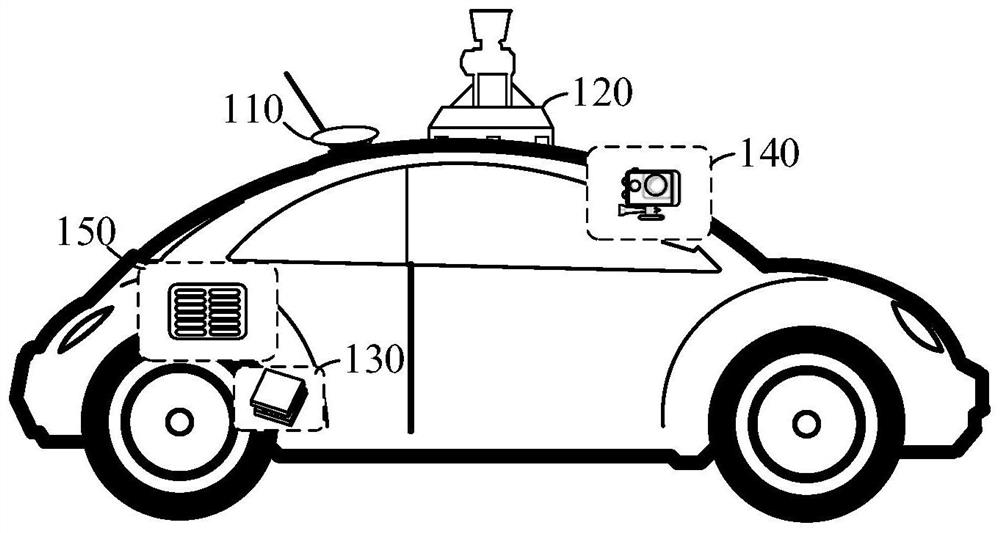
[0034] 3D point cloud data refers to a set of vectors in a 3D coordinate system. These vectors are usually expressed in the form of x, y, z three-dimensional coordinates, and are generally mainly used to represent the outer surface shape of an object. Exemplary, P k ={x k ,y k ,z k} represents the kth point in the space, Point Cloud={P 1 ,P 2 ,P 3 ,...,P v} represents a set of point cloud data, and k and v are positive integers. Exemplarily, the above-mentioned 3D point cloud data is generated by a 3D scanning device, such as lidar, stereo camera, and time-of-flight camera.

[0035] The map scanning equipment scans the environment to obtain 3D po...


PUM


Abstract

The invention discloses a point cloud map construction method and device, equipment, a storage medium and a computer program, and belongs to the technical field of map construction. The method comprises the steps of acquiring three-dimensional point cloud data, wherein the three-dimensional point cloud data is obtained by scanning an environment in a block region by map scanning equipment, and the block region is a sub-region obtained by blocking a whole mapping region; associating the three-dimensional point cloud data to pose information of the map scanning equipment according to the timestamp; when the confidence coefficient of the pose information is less than a confidence coefficient threshold value, optimizing the pose information through the partitioned point cloud map and the local point cloud map to obtain optimized pose information; and splicing the three-dimensional point cloud data to the block point cloud map and the local point cloud map based on the optimized pose information. According to the method, the problems that the combined inertial navigation is easily influenced by factors such as weather and object shielding, and the output pose information is inaccurate can be avoided.

Description

technical field [0001] The present application relates to the technical field of map construction, and in particular to a point cloud map construction method, device, equipment, storage medium and computer program. Background technique [0002] In the application fields of autonomous driving, smart city, Internet of Things, and other small and precise vertical applications, high-precision maps have broad application value. It can be generated by point cloud data collected by vehicle lidar. [0003] For example, when the vehicle is running, the position and orientation information of the vehicle is recorded at various times through the combined inertial navigation, and the three-dimensional point cloud data at each time is collected through the laser radar, and then the above three-dimensional point cloud data is processed based on the above position and orientation information. Stitching to generate high-precision maps. [0004] However, the pose information of the vehicle...

Claims


Application Information

Patent Timeline
Patent Type & Authority Applications(China)
IPC IPC(8): G06T17/00G06T3/40G06T7/73
CPCG06T17/00G06T3/4038G06T7/73G06T2200/32G06T2207/10028G06T2207/30252G06T2200/08
Inventor 刘健余丽邱靖烨张立鹏夏华夏
Owner BEIJING SANKUAI ONLINE TECH CO LTD
Why Eureka
Try Eureka