A method and system for determining the size of a population distribution grid

A population distribution and grid technology, which is applied to instruments, geographic information databases, still image data retrieval, etc., can solve problems such as long analysis time, inability to determine the population grid scale, too large research area and population data, etc., to improve The effect of accuracy

Active Publication Date: 2022-05-10
CHINESE ACAD OF SURVEYING & MAPPING
View PDF0 Cites 0 Cited by
  • Summary
  • Abstract
  • Description
  • Claims
  • Application Information

AI Technical Summary

Problems solved by technology

[0005] In view of the above problems, the purpose of the present invention is to solve the problem that in the process of spatialization of population...

Method used


Image

  • A method and system for determining the size of a population distribution grid
  • A method and system for determining the size of a population distribution grid
  • A method and system for determining the size of a population distribution grid

Examples


Embodiment 1

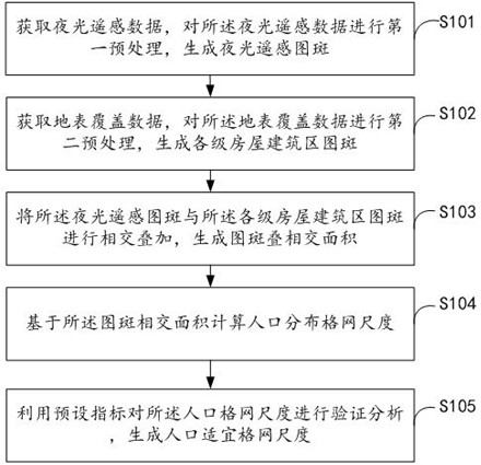
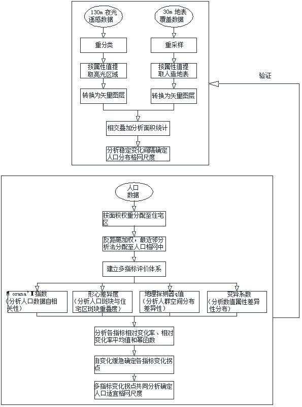
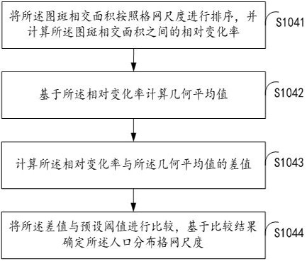
[0160] Intersect and superimpose the luminous remote sensing map spot and the building construction area map spot at all levels to generate the overlapping overlapping area of ​​the map spot, refer to Figure 5As shown, the power function curve is generated based on the intersection area of ​​the patch (that is, the overlapping area) and the grid scale. From the power function curve, it can be seen that as the grid scale increases, the intersection area of ​​the patch also increases and tends to be stable, and the record is stable. The change interval of 80m-105m is the population distribution grid scale.

[0161] Calculating the spatial autocorrelation of the first preset indicator is derived from value, and based on value and its relative rate of change to generate a power function curve, refer to Figure 6 It can be seen from the power function curve that as the grid scale increases, The value shows a decreasing trend, indicating that the increase of the grid scale in...


PUM


Abstract

The invention discloses a method and system for determining the size of a population distribution grid. The method includes: acquiring luminous remote sensing data, performing first preprocessing on the luminous remote sensing data to generate luminous remote sensing pattern spots; acquiring land cover data, and performing the first preprocessing on the luminous remote sensing data; The second preprocessing is performed on the land cover data to generate the map spots of building construction areas at all levels; the luminous remote sensing map spots and the map spots of the building construction areas at all levels are intersected and superimposed to generate the overlapping area of ​​map spots; based on the The grid scale of population distribution is calculated by the intersection area of ​​map spots. This method realizes the determination of the population grid scale in the study area without using population data.

Description

technical field [0001] The invention relates to the technical field of data mining, in particular to a method and system for determining the size of a population distribution grid. Background technique [0002] In recent years, the rapid development of big data and information technology has brought about the combination of more and more data and visualization technology, which greatly improves the readability of data. Among them, statistical data on population are often aggregated level by level within administrative divisions, combined with rigorous statistical theories and methods, to make them authoritative, systematic, and normative, and research on the spatialization of population data starts from demographic and administrative From the operation of spatial interpolation of zoning data to the use of various reference data and multi-element models that have a high spatial correlation with the spatial distribution of population, such as high-resolution images, topographi...

Claims


Application Information

Patent Timeline
IPC IPC(8): G06F16/29G06F16/51G06F16/587
CPCG06F16/29G06F16/51G06F16/587
Inventor 董春罗永臻张玉康风光
Owner CHINESE ACAD OF SURVEYING & MAPPING
Why Eureka
Try Eureka