High-stability surveying and mapping support for geological surveying and mapping

A technology of stability and geology, applied in the field of surveying and mapping brackets, can solve the problems of poor stability of tripods, low work efficiency, inconvenient fine-tuning of angles, etc., so as to reduce the impact, improve the firmness and ensure the stability.

Pending Publication Date: 2022-03-18
方宇勘测有限公司
View PDF4 Cites 2 Cited by
  • Summary
  • Abstract
  • Description
  • Claims
  • Application Information

AI Technical Summary

Problems solved by technology

"However, this surveying and mapping bracket is not convenient to assemble with surveying instruments of different sizes, thereby reducing the applicability of this equipment;
[0006] 3. The patent document CN213872059U discloses a high-stability total station bracket, "This application solves the problem that existing high-stability total station brackets are inconvenient for angle fine-tuning, work efficiency is low, and the tripod Poor stability, unable to adapt to the problem of measurement work in harsh geological environments
"However, the surveying instrument assembled with this equipment is not easy to use in rainy days

Method used


Image

  • High-stability surveying and mapping support for geological surveying and mapping
  • High-stability surveying and mapping support for geological surveying and mapping
  • High-stability surveying and mapping support for geological surveying and mapping

Examples


Embodiment 1

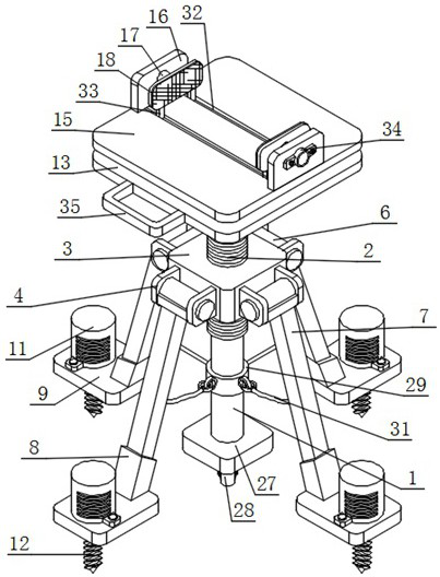
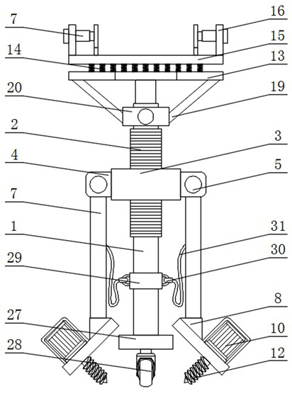
[0044] Such as figure 1 , figure 2 , image 3 , Figure 4 and Figure 5 As shown, a surveying and mapping bracket with high stability for geological surveying and mapping includes an electric lifting rod 1, a threaded sleeve 2, a square connecting block 3 and a fixing plate 4, and the outer surface of the electric lifting rod 1 is equipped with a threaded sleeve 2;

[0045] The outer surface of the threaded sleeve 2 is equipped with a square connecting block 3, and the front, back and outer walls of both sides of the square connecting block 3 are equipped with two sets of symmetrically arranged fixing plates 4;

[0046] Specifically, after the electric elevating rod is started, it can perform the operation of extending upwards or shrinking downwards accordingly, and then it can drive the parts on the top to move up and down, so as to adjust the height position of the surveying instrument placed above the working board 15. The sleeve 2 and the electric lifting rod 1 are as...

Embodiment 2

[0050] Such as figure 1 , figure 2 and Figure 7 As shown, an integrated plate 13 is installed on the top of the electric lifting rod 1, and multiple sets of evenly arranged buffer springs 14 are installed on the top of the integrated plate 13. A working plate 15 is installed on the top of the multiple sets of buffer springs 14, and a working plate 15 is installed on the top of the working plate 15. There are two groups of combined boards 16 arranged side by side. Miniature electric push rods 17 are installed through one side of the outer walls of the two groups of combined boards 16 , and snapping plates 18 are installed at one end of the two groups of miniature electric push rods 17 .

[0051] Specifically, the integrated board 13 provides a relatively stable and suitable installation site for the buffer spring 14. During the movement of the device, the bottom of the device will collide with the ground, and then the impact force generated by the collision will be transmitt...

Embodiment 3

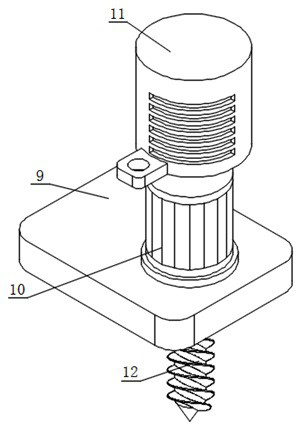
[0053] Such as figure 2 and Figure 6 As shown, the bottom of the integrated board 13 is equipped with four groups of inclined rods 19 arranged in a square shape, and a collar 20 is installed on one end of the four groups of inclined rods 19, and the collar 20 surrounds the outer side of the electric lifting rod 1, and the outer side of the collar 20 Fastening rods 21 are installed on the front and back, and fitting rings 22 are installed on the outer surfaces of two groups of fastening rods 21, wherein the backs of one group of fitting rings 22 and the fronts of the other group of fitting rings 22 are installed There is a fastening plate 23, and the outer wall of the fastening plate 23 is attached to the outer surface of the electric lifting rod 1.

[0054] Specifically, the inclined rod 19 is used to connect the integrated plate 13 and the collar 20, and the inner diameter of the collar 20 is larger than the outer diameter of the threaded sleeve 2. When the electric telesc...


PUM


Abstract

The high-stability surveying and mapping support for geological surveying and mapping comprises an electric lifting rod, a threaded sleeve, a square connecting block and a fixing plate, and the threaded sleeve is installed on the outer surface of the electric lifting rod; a square connecting block is installed on the outer surface of the threaded sleeve, and two sets of symmetrically-arranged fixing plates are installed on the front face, the back face and the outer walls of the two sides of the square connecting block; round rods are installed on the outer walls of one sides of the four sets of fixing plates in a penetrating mode, and movable sleeves are installed on the outer surfaces of the round rods. The four sets of drill rods can drill into the deep position of the ground, so that positioning placement is facilitated, the placement stability of the equipment is improved, meanwhile, the equipment can be assembled with surveying instruments of different sizes, the equipment and the surveying instruments are fastened and assembled through clamping plates, and when the surveying instruments are used, the shielding shed can be stretched to shield wind and rain for the surveying instruments; in the equipment, the comprehensive plate and the electric lifting rod are connected in a multi-point manner, and connecting points are increased, so that the assembly firmness of the comprehensive plate and the electric lifting rod is ensured.

Description

technical field [0001] The invention relates to the technical field of surveying and mapping supports, in particular to a highly stable surveying and mapping support for geological surveying and mapping. Background technique [0002] In geological exploration, mineral development, water conservancy, transportation and other constructions, control surveys, mine surveys, route surveys and topographic maps must be carried out for geological surveys and various building design and construction, and surveying and mapping instruments must be used during the surveying process. Among them, the surveying and mapping instrument needs to be equipped with a surveying and mapping bracket for support. [0003] The defective that existing surveying and mapping support exists is: [0004] 1. The patent document CN210531951U discloses a bracket for geological surveying instruments that is easy to adjust, "comprising a main rod, a connecting block is welded on the main rod, and three sets of...

Claims


Application Information

Patent Timeline
Patent Type & Authority Applications(China)
IPC IPC(8): F16M11/24F16M11/04F16M11/18
CPCF16M11/24F16M11/245F16M11/247F16M11/04F16M11/046F16M11/18
Inventor 王田磊
Owner 方宇勘测有限公司
Why Eureka
Try Eureka