
Calculation method for satellite observation of urban surface temperature angle effect

A technology of surface temperature and satellite observation, applied in radiation pyrometry, satellite radio beacon positioning system, measuring device, etc., can solve problems such as expansion

Active Publication Date: 2022-04-12
CHINA UNIV OF GEOSCIENCES (BEIJING)
View PDF7 Cites 0 Cited by
  • Summary
  • Abstract
  • Description
  • Claims
  • Application Information

AI Technical Summary

Problems solved by technology

[0007] Aiming at the problem that the above method is only applicable to cities along the water, the present invention provides a calculation method for satellite observation of urban surface temperature angle effects, which omits the use of water bodies to remove atmospheric effects on the basis of evaluating the residual atmospheric effects in temperature products. item, so that the method no longer needs water body surface temperature and near-surface air temperature as input data, thereby overcoming the defect that the existing method can only be applied to coastal (water) cities, and greatly expanding the application of this method to urban surface satellite surface temperature Universal Applicability of (LST) Angle Effect Assessment

Method used


Image

  • Calculation method for satellite observation of urban surface temperature angle effect
  • Calculation method for satellite observation of urban surface temperature angle effect
  • Calculation method for satellite observation of urban surface temperature angle effect

Examples


Embodiment Construction

[0026] In order to make the purpose, technical solutions and advantages of the embodiments of the present invention more clear, the technical solutions in the embodiments of the present invention will be clearly and completely described below in conjunction with the drawings in the embodiments of the present invention.

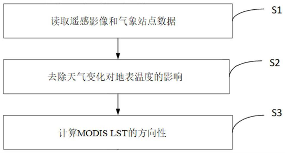
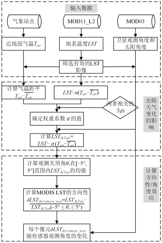
[0027] The calculation method of satellite observation city surface temperature (LST) angle effect of the present invention, comprises the following steps: S1. read remote sensing image and meteorological station data; S2. remove the impact of weather change on surface temperature (LST); and S3. calculate Directionality of MODIS Land Surface Temperature (LST). Since the MODIS LST product has adopted the split window algorithm to remove the atmospheric influence during the production process, the residual atmospheric influence is small, and if the atmospheric influence is taken as part of the assessment result, the step of using water to remove the atmospheric i...


PUM


Abstract

The invention discloses a calculation method for satellite observation of an urban surface temperature (LST) angle effect. The method comprises the following steps: S1, reading a remote sensing image and meteorological station data; s2, the influence of weather changes on the surface temperature (LST) is removed; and S3, calculating the directivity of the MODIS surface temperature (LST). According to the method, on the basis of evaluating the residual atmospheric effect in a temperature product, the item of removing the atmospheric effect influence by using a water body is omitted, so that the method does not need the water body surface temperature and the near-surface air temperature as input data any more, and the defect that an existing method is only suitable for coastal (water) cities is overcome; according to the method, large-range and long-time calculation of the satellite angle effect can be realized, the universality of the method applied to evaluation of the urban surface satellite surface temperature (LST) angle effect is greatly expanded, and the satellite angle effect of global cities can be calculated.

Description

technical field [0001] The invention relates to the field of surface temperature measurement, in particular to a calculation method for satellite observation of urban surface temperature angle effects. Background technique [0002] Surface temperature is an important driving force for the exchange of matter and energy at the surface. Thermal infrared remote sensing is an important means to quickly obtain large-scale surface temperature. The surface temperature products retrieved by remote sensing have been widely used in the fields of surface water and heat balance, ecological environment monitoring, and global change. The remarkable three-dimensional structure and complex material of the urban surface make the urban surface show a strong thermal radiation directionality, which in turn causes the surface thermal radiation observed by the thermal infrared sensor to change with the observation angle, and the angle effect of the urban surface temperature caused by satellite rem...

Claims


Application Information

Patent Timeline
Patent Type & Authority Applications(China)
IPC IPC(8): G01J5/00G01S19/37
CPCY02A90/10
Inventor 王丹丹何晓宇吴佳桐
Owner CHINA UNIV OF GEOSCIENCES (BEIJING)
Learn More