Earth cover identification and area estimation method based on cloud platform and random forest

A technology of ground cover and random forest, which is applied in the field of surface cover identification and area estimation, can solve the problems of time-consuming downloading, cumbersome calculation methods, and many processes, so as to improve classification accuracy and scope of application, increase time efficiency and Economic benefits and the effect of improving interpretation accuracy

Pending Publication Date: 2022-04-12
NANJING AUTOMATION INST OF WATER CONSERVANCY & HYDROLOGY MINIST OF WATER RESOURCES +1
View PDF0 Cites 1 Cited by
  • Summary
  • Abstract
  • Description
  • Claims
  • Application Information

AI Technical Summary

Problems solved by technology

[0003] (1) Low efficiency of remote sensing data processing
The traditional download-use method needs to spend a lot of time downloading data in a large-space storage medium, which cannot meet the needs of various industries for fast and efficient realization of large-scale, high-precision, and long-term remote sensing monitoring;
[0004] (2) The accuracy of computer interpretation method is not high
The existing computer interpretation method is mainly based on the threshold method, which is difficult to identify the ground cover with similar spectral characteristics or similar colors, and is often prone to misclassification;
[0005] (3) Interpretation method is not universal
When the common interpretation methods are applied in different areas, professional technicians need to adjust the interpretation parameters according to the terrain and landform, which greatly increases the threshold of use and is difficult to promote and apply;
[0006] (4) Local computing power is too low
[0007] (5) The rapid calculation method of the classified area of ​​land cover is cumbersome and the degree of automation is low
[0008] The area of ​​land cover is an important indicator for studying and analyzing regional environmental change trends. Existing professional software needs to process images in advance, create new attribute fields, and finally use computational geometry functions for calculations. There are many processes and the whole process is uniform. It is a manual operation, and it is difficult to achieve multi-category land cover area statistics

Method used


Image

  • Earth cover identification and area estimation method based on cloud platform and random forest
  • Earth cover identification and area estimation method based on cloud platform and random forest
  • Earth cover identification and area estimation method based on cloud platform and random forest

Examples


Embodiment Construction

[0034] The technical solutions provided by the present invention will be described in detail below with reference to specific embodiments. It should be understood that the following specific embodiments are only used to illustrate the present invention and not to limit the scope of the present invention. The methods provided by the present invention may be performed in a computer system, such as a set of computer-executable instructions.

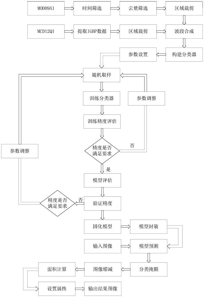
[0035] The present invention provides a land cover classification and area calculation method based on a cloud platform and random forest. The detailed process is as follows: figure 1 It mainly includes the following steps:

[0036] Step 1: Filter the MOD09A1 data set in the Google Earth Engine platform, use filterDate to filter the date, and in the StateQA band according to cloud status (0-1 bit), cloud shadow (2nd bit), internal algorithm flag (10th bit) ), the pixel is adjacent to the cloud (13th) to filter the low cloud cover image data...


PUM


Abstract

The invention provides a ground cover classification and area calculation method based on a cloud platform and a random forest, a set of multiband remote sensing data preprocessing technology based on MOD09A1 and MCD12Q1 is formed based on a Google Earth Engine cloud platform, and the method mainly comprises the steps of data set selection, data quality evaluation, data cutting, multiband remote sensing data set band synthesis and the like. And a random forest surface cover classification model based on multi-band remote sensing data is constructed, an image reduction function and image spatial-temporal feature information are combined, surface covers in a large range can be simply, conveniently, efficiently and quickly identified in a cloud computing mode, and the area of the regional surface covers is calculated. According to the invention, by fully utilizing the strong computing power of the cloud platform, the land coverings in a large area can be quickly classified, the area can be estimated, and the change trend of the land coverings in a time sequence can be counted.

Description

technical field [0001] The invention belongs to the technical field of cloud computing and machine learning, and in particular relates to a method for identifying and estimating area of ​​ground cover based on a cloud platform and a random forest. Background technique [0002] Changes in surface cover are inseparable from changes in the natural environment and human activities, and are one of the important basic data for the study of climate change, ecological environment conditions, and the causes of geological disasters. In recent decades, with the continuous progress of science and technology and the continuous launch of remote sensing satellites, the temporal and spatial resolution of remote sensing images have been greatly improved, and the amount of remote sensing-related data has also increased geometrically, which makes the use of remote sensing images. Satellite remote sensing makes it possible to continuously monitor changes in land cover. However, there are still...

Claims


Application Information

Patent Timeline
Patent Type & Authority Applications(China)
IPC IPC(8): G06V20/13G06V10/764G06V10/774G06K9/62
Inventor 丁炜牛睿平金有杰林艳燕杨帆陈季俞蕊张日
Owner NANJING AUTOMATION INST OF WATER CONSERVANCY & HYDROLOGY MINIST OF WATER RESOURCES
Why Eureka
Try Eureka