
Vision-based unmanned aerial vehicle landing attitude estimation method

An attitude estimation and unmanned aerial vehicle technology, applied in the field of unmanned aerial vehicles, can solve the problems that satellite navigation systems are susceptible to interference and do not meet the performance requirements of fine-grained navigation tasks.

Pending Publication Date: 2022-05-13
丁莹莹
View PDF0 Cites 0 Cited by
  • Summary
  • Abstract
  • Description
  • Claims
  • Application Information

AI Technical Summary

Problems solved by technology

Satellite navigation systems are susceptible to interference, mainly from dense cloud cover, solar flares, and permanent obstacles such as trees and buildings, and do not meet the performance requirements for fine-grained navigation tasks, such as drones on runways, helipads, or nets landing

Method used


Image

  • Vision-based unmanned aerial vehicle landing attitude estimation method
  • Vision-based unmanned aerial vehicle landing attitude estimation method
  • Vision-based unmanned aerial vehicle landing attitude estimation method

Examples


Embodiment Construction

[0038] The present invention will be further described below in conjunction with the accompanying drawings and embodiments.

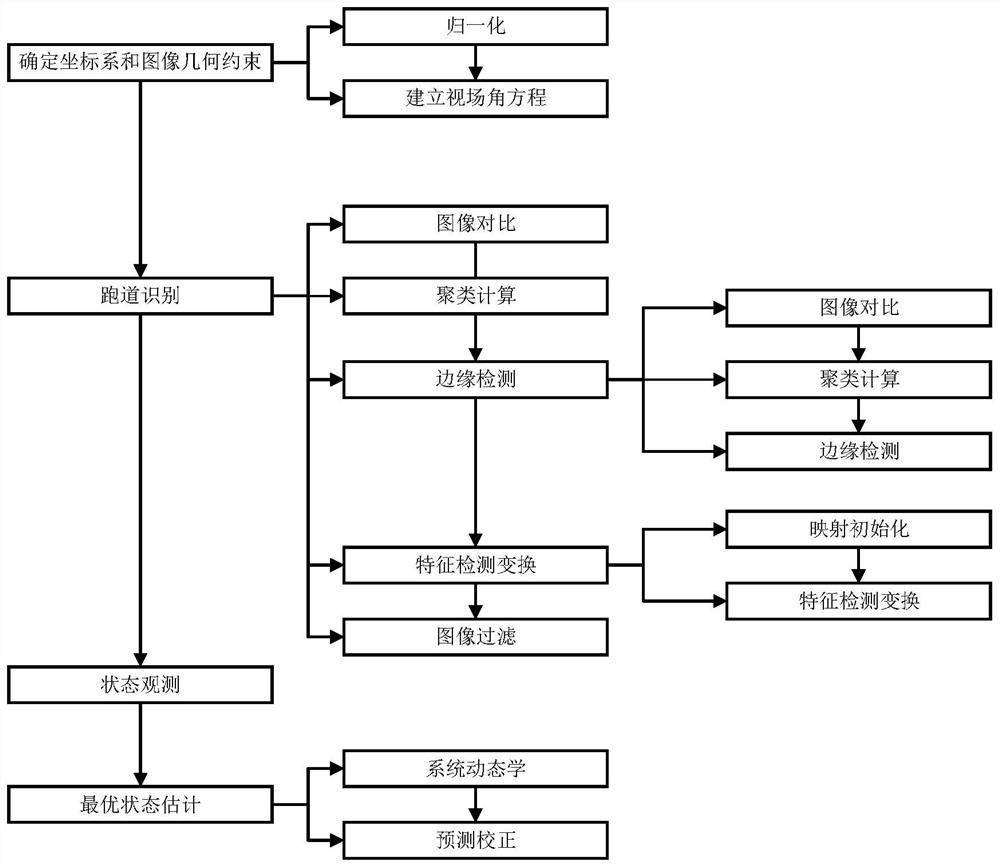
[0039] A vision-based approach to UAV landing attitude estimation, which is used to augment or support satellite navigation systems as the primary means of navigation during UAV landing, using clustering techniques to identify runway markings, using edge detectors and features Detect transformations to verify that markers are located on recovery targets, use optimizers to match detected markers to coordinates in 3D space, use nonlinear transformation and projection solvers to view camera position and orientation, use extended Kalman filtering to improve pose estimation.

[0040] The proposed algorithm of this method gives better pose estimation than existing vision systems.

[0041] The method includes:

[0042] Step 1. Determine the coordinate system and image geometric constraints,

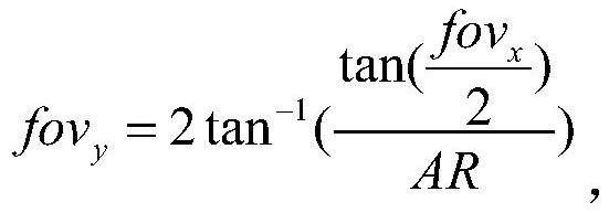
[0043] Control the field of view or zoom of the onboard camera. T...


PUM


Abstract

A vision-based unmanned aerial vehicle landing attitude estimation method uses a clustering technology to identify runway marks, uses an edge detector and feature detection transformation to verify whether the marks are located at a recovery target, uses an optimizer to match the detected marks with coordinates in a three-dimensional space, and uses a three-dimensional space to estimate the landing attitude of the unmanned aerial vehicle. Using nonlinear transformation and a projection solver to observe the position and direction of the camera, and using an extended Kalman filter to obtain optimal attitude estimation; target images, corner marker colors, edge colors, and runway target geometry are input, an onboard camera will provide images, and attitude estimates will be passed to a camera controller and an automatic landing controller, the former being used to adjust the angle of view.

Description

technical field [0001] The invention relates to an unmanned aerial vehicle, in particular to a vision-based method for estimating the landing attitude of an unmanned aerial vehicle. Background technique [0002] Current attitude estimation for UAVs usually requires the use of satellite navigation systems. Satellite navigation systems are well suited for medium resolution navigation requirements. More advanced units with RTK capabilities provide accuracy on the order of a few inches, or even better under perfect conditions. accuracy. However, the performance of such devices depends on satellite availability, dynamic conditions, and even geographic features. Satellite navigation systems are susceptible to interference, mainly from dense cloud cover, solar flares, and permanent obstacles such as trees and buildings, and do not meet the performance requirements for fine-grained navigation tasks, such as drones on runways, helipads, or nets landing. In addition, UAVs often lan...

Claims


Application Information

Patent Timeline
IPC IPC(8): G01C11/04G01C11/02G01C1/00
CPCG01C11/04G01C11/02G01C1/00
Inventor 丁莹莹赵云昌
Owner 丁莹莹
Learn More