Method for calculating global terrain correction based on multi-resolution polyhedron under hexagonal grid index

A hexagonal grid, multi-resolution technology, applied in computing, instrumentation, image data processing, etc., can solve problems such as influence, and achieve the effect of small long wavelength error, high efficiency and high precision calculation

Active Publication Date: 2022-05-24
PLA STRATEGIC SUPPORT FORCE INFORMATION ENG UNIV PLA SSF IEU
View PDF4 Cites 2 Cited by
  • Summary
  • Abstract
  • Description
  • Claims
  • Application Information

AI Technical Summary

Problems solved by technology

[0003] In the process of geoid refinement and determination of the earth's gravity field, the present invention aims at the problem that the time-consuming and efficiency of calculation directly affects the efficiency of geoid refinement and gravity field data processing, and proposes a method based on hexagonal grid index The multi-resolution polyhedron calculation method of global terrain correction not only effectively takes into account the curvature of the earth, the impact of global terrain quality and the loss of seawater mass density, but also solves the high-precision calculation of local area terrain correction using multi-resolution terrain models. Prism integration method, point quality, line quality, Tesseroid method, the calculation efficiency is significantly improved

Method used


Image

  • Method for calculating global terrain correction based on multi-resolution polyhedron under hexagonal grid index
  • Method for calculating global terrain correction based on multi-resolution polyhedron under hexagonal grid index
  • Method for calculating global terrain correction based on multi-resolution polyhedron under hexagonal grid index

Examples


Embodiment Construction

[0039] The present invention will be further explained below in conjunction with the accompanying drawings and specific embodiments:

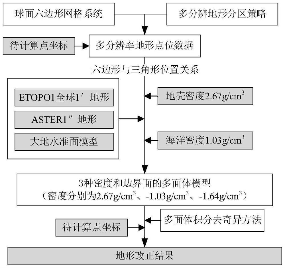
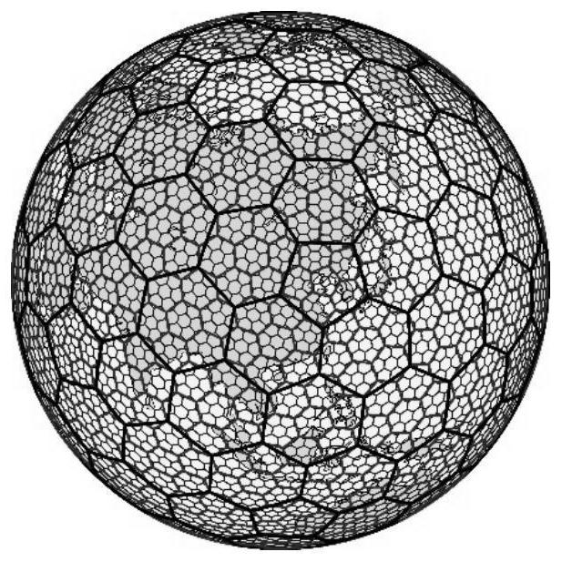
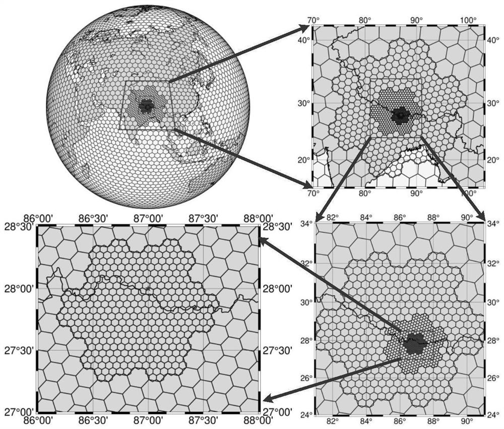
[0040] like figure 1 As shown in the present invention, a method for calculating global terrain correction based on a multi-resolution polyhedron under a hexagonal grid index, firstly, using a spherical hexagonal grid system to perform multi-resolution division on the earth to obtain different resolutions The high-rate hexagonal grid realizes the coordinates of the points in the hexagonal grid, the coordinates of the boundary points, and the index of the position relationship between the grids; secondly, according to the multi-resolution terrain partition strategy in the terrain correction calculation, According to the location and area size, combined with the requirements for the calculation accuracy of terrain correction, the partition parameters under the hexagonal grid are determined; The mass density of seawater is deficient, and the mult...


PUM


Abstract

The invention discloses a method for calculating global terrain correction based on a multi-resolution polyhedron under a hexagonal grid index. The method comprises the following steps: constructing a spherical hexagonal grid system H3 of 7-hole subdivision based on an icosahedron; constructing a terrain partitioning strategy under the H3 based on the H3 and each grid parameter; determining a polyhedral model of a multi-resolution terrain by using a corresponding relation between a hexagonal grid and a triangular surface, considering seawater mass density loss, and determining the terrain correction influence on a to-be-calculated point by using a polyhedral integration method; and by utilizing the constructed polyhedral model and the corresponding seawater mass density thereof, determining a gravitational force value corresponding to each polyhedral model at the point to be calculated by using a polyhedral integration method, and taking the sum of a plurality of groups of gravitational force values as a final terrain correction value at the point to be calculated. According to the method, the long wavelength error of terrain correction is smaller, and meanwhile high-precision calculation of terrain correction of a local area is achieved through a multi-resolution terrain model.

Description

technical field [0001] The invention belongs to the technical fields of geodetic surveying and mapping engineering and solid geophysics, and in particular relates to a method for calculating global terrain correction based on multi-resolution polyhedrons under hexagonal grid indexes. Background technique [0002] Terrain has an important influence on the relevant earth gravity field elements (such as gravity anomaly, disturbed gravity, geoid height, vertical line deviation, second-order gradient of disturbance position, etc.) It plays an important role in the construction of the earth, and also plays an important role in the inversion of the density and geological structure of the earth's interior in geophysics. Prism and Tesseroid methods are mostly used for terrain correction. With the continuous improvement of the resolution of global terrain models to better than 30m, the computational time and efficiency directly affect the efficiency of geoid refinement and gravity fie...

Claims


Application Information

Patent Timeline
Patent Type & Authority Applications(China)
IPC IPC(8): G06T17/20
CPCG06T17/205Y02A90/10
Inventor 李新星范昊鹏刘晓刚李姗姗王傲明冯进凯范雕
Owner PLA STRATEGIC SUPPORT FORCE INFORMATION ENG UNIV PLA SSF IEU
Why Eureka
Try Eureka